Karya I Made Andi Arsana, ST., ME Batas Maritim Antarnegara - Sebuah Tinjauan Teknis dan Yuridis (Gadjah Mada University Press, 2007) more...

Monday, April 25, 2005

International Workshop Publication

Department of Geodetic Engineering, Gadjah Mada University
in collaboration with
National Coordinating Agency for Surveys and Mapping

Proudly presents:

INTERNATIONAL WORKSHOP ON LEGAL AND TECHNICAL ASPECTS OF MARITIME BOUNDARY DELIMITATION

Yogyakarta, 6-7 May 2005


I. Background
As an archipelagic country, Indonesia has some potential maritime boundary with some adjacent and opposite neighbouring coastal States. This is due to potential overlapping claims of maritime zone between Indonesia and its neighboring States. With regards to potential maritime boundaries, ten States are considered: Republic Democratic of Timor Leste (RDTL), Malaysia, Papua New Guinea, Singapore, Australia, Palau, Philippines, Thailand, India and Vietnam.

Most of the boundaries have not been fully established. The case of Ambalat is one of the consequences of the pending agreement of maritime boundary between Indonesia and Malaysia in Celebes Sea. The ownership of Batek Island is also an important issue that Indonesia and RDTL need to agree upon, as the steps to establish maritime boundaries between the two countries. These situations potentially raise conflict between the States in question and at the end cause inconvenience to the inhabitants in rolling their economic activities. On the other hand, Indonesian societies, in general, are quite easy to be negatively provoked with regards to boundary issue. In most cases, they do not really understand the real problem, especially in terms of legal and scientific substance. In addition, unbalanced reporting by newspaper and electronic media sometimes also worsens the situation.

Indonesia ratified the United Nation Convention on the Law of the Sea III (1982) in 1985. However, it faced several technical and non-technical obstacles in implementing the Convention to generate acceptable maritime boundaries. The problems include funding matter, partial claim by neighbouring states, and the availability of legal administrative resources/documents for negotiations.

This workshop is proposed based on two key reasons: the complexity of the maritime boundary definition that needs proper training, and the lack of information distribution among societies, especially with regards to legal, technical and historical aspects. This is expected to facilitate the share of knowledge among experts, technical contributors and even ordinary people about maritime boundary delimitation to obtain an equitable solution.

II. Aims and objectives

  1. To socialize legal and technical aspects of maritime boundary delimitations.

  2. To socialize approaches employed in solving cases related to maritime boundary dispute.

III. Schedule

IV. Fees and Registration:

  1. Indonesian participants

    1. Full booth ( workshop kit dan penginapan) Rp 750.000,-

    2. Standar (workshop kit tanpa penginapan) Rp. 500.000,-

  2. Overseas Participants

    1. $US 250.00 (with workshop kit only)


For registration, please contact:
Committee secretariat for International Workshop of Department of Geodetic Engineering, Gadjah Mada University
Jl. Grafika No.2 Yogyakarta
P: +62 274 520226 atau +62 274 902121
F: +62 274 520226
E: geodesy_ugm@yahoo.com, dwil_yk@yahoo.com

Fees can be transfered to Bank Account:
Bank Mandiri MM-UGM Branch
Account number: 137.0002172.514
Account holder: Ketua Jurusan Teknik Geodesi FT-UGM

Contact persons:
Dwi Lestari +62 8132 8175507
Abdul Basith +62 815 7941196

Tertarik mengikuti workshop International ini?
Silahkan lihat di sini

Sampai jumpa di Jogja!

More...

Thursday, April 21, 2005

A Formal letter from DGE

More...

Monday, April 18, 2005

Seminar and Workshop in Indonesia

[another one about Ambalat]

Department of Geodetic Engineering (DGE), Gadjah Mada University actively responds the case of Ambalat, the overlapping claim between Indonesia and Malaysia. As an academic institution, DGE in collaboration with Bakosurtanal will conduct a seminar and workshops related to international boundaries. The series of activities will last for one week at the beginning of May 2005.

Invited in the seminar (3 May 2005) and workshops (6-7 May 2005) are the top-notch people in the area of boundary issues. Amongst them are Ministry of Home affairs, experts from Indonesia’s Department of Foreign Affairs, Bakosurtanal, Department of Defense, Indonesian Universities, etc.

Clive, my supervisor, will also be invited as an international expert in maritime boundaries to present a paper in the seminar. He will also be giving a workshop in legal and technical aspect of maritime boundaries on 6 May 2005. Besides, he will be treated as a visiting fellow to discuss the possibility of conducting joint-researches between CMP, where Clive is currently working, and DGE and also to discuss the new curriculum that contains the course of boundary issue.

I, myself, will come along with Clive and am expected to be the moderator for one of the sessions in the seminar when Clive and Sobar Sutisna, the Chief of Center for Boundary Mapping of Bakosurtanal, present. It will be such a challenging chance for me. On 7 May 2005, I will also be one of the presenters in the workshop giving the material related to the use of CARIS LOTS™ in maritime boundary delimitations.

The following are program details.
3 May 2005: National Seminar

9.00 – 9.30 Keynote Speech and Opening
Presenter:
Let. Jen. (Purn) M. Ma'ruf, Indonesian Minister of Internal Affairs
09.30-09.45 morning coffee
09.45-11.00: Session I Ambalat Case Study: A legal and political perspective
Presenters:
• Arif Havas Oegroseno, SH, LLM, Department of Foreign Affairs
• Prof. Dr. F Sugeng Istanto, SH Faculty of Law, Gadjah Mada University
11.00-12.15 Session II
Ambalat Case Study: A security/defense and socio-cultural perspective
Presenters:
• Drs. Lambang Triyono, M.A, Center for security and peace studies, UGM
• Ir. Iswinardi, M.Sc Department of Defense, Indonesia
12.15-13.15 break
13.15-14.30 Session III
The Boundary of the Indonesian Archipelago
Presenters:
Kol. Laut Drs. Rusdi Ridwan, Dipl.Cart, Dishidros
Dr. Budi Sulistyo M.Sc, Indonesia’s Dept. of Marine Affairs & Fisheries
14.30-15.45 Session IV
International Boundaries
Presenters:
• Ir. Sobar Sutisna M. Surv, Ph.D, Bakosurtanal
• Dr. Clive Schofield, CMP, University of Wollongong, Australia
15.45-16.15 Conclusion and Closing

4 May 2005: General Lecture and Discussion on Joint-research and curriculum
5 May 2005: Field Trip
6-7 May 2005
Workshop Title: INTERNATIONAL WORKSHOP ON LEGAL AND TECHNICAL ASPECTS OF MARITIME BOUNDARY DELIMITATION

6 May 2005: Workshop day 1 (DR Clive Schofield)
07.00 - 08.30 Registration and Morning Coffee
08.30 - 09.00 opening Speech (Sumaryo, Martindas)
09.00 - 09.30 Historical background to the Law of the Sea Convention
09.30 - 10.45 Baselines and Technical Issues in the Law of the Sea
10.45 - 11.45 Maritime Zones of Jurisdiction under Sovereignty and Sovereign Rights
11.45 - 13.30 Friday Prayer + Lunch
13.30 - 14.30 The Delimitation of Maritime Boundaries
14.30 - 15.30 Maritime Boundary Disputes
15.30 - 16.00 Coffee Break
16.00 - 17.00 Maritime Boundary Dispute Resolution

7 May 2005: Workshop day 2

07.00 - 08.00 Registration
08.00 - 09.30 The role of geospatial data in Boundary delimitation (Dr. Sobar Sutisna)
09.30 - 10.00 Coffee Break
10.00 - 11.30 Maritime Boundary disputes and resolution (Ary Havas Oegroseno,DEPLU)
11.30 - 13.00 Land Boundary disputes and equitable boundary delineation (Ir. Klaas Vilaeneuva)
13.00 - 14.00 Lunch break
14.00 - 15.30 Continental Shelf Boundary Delimitation, Art.76 UNCLOS (Dr. Khafid, BAKO)
15.30 - 15.45 Coffee break
15.45 - 17.00 Introduction to CARIS LOTS™: An assisting tool for maritime boundary delimitation, I Made Andi Arsana, DGE

More...

Thursday, April 14, 2005

I am in The Jakarta Post!

There is no perfect words to describe how happy I am today. My article about Ambalat has been published in The Jakarta Post. After a month of waiting, It was finally published on April 12, 2005. So proud about that, since it is the first article published in a national English Daily.

Should you be interested pelase read here

I dedicated the writing to Asti and my child-to-be!

More...

Saturday, April 09, 2005

Ambalat: A Spatial Perspective1


I Made Andi Arsana 2
School of Surveying and Spatial Information Systems
The University of New South Wales
madeandi@student.unsw.edu.au

Abstract

During March 2005, bilateral relationship between Indonesia and Malaysia escalates. The rising matter relates to Malaysia’s claim over Ambalat area located in the east of Borneo Island, while Indonesia, in the other side, is sure the area belongs to Indonesia.

Reactive responses come from most of Indonesians because they, generally, believe that it is another manifestation of Malaysia’s greediness. This is understandable since Malaysia won the case on Sipadan and Ligitan (two islands located near Ambalat) over Indonesia in 2002 causing Malaysia successfully took the two islands3. No matter what the reasons the ICJ proposed in deciding the case, most of Indonesian citizens are simply disappointed. Since such case is very sensitive, with regards to Ambalat case, people from both countries have to really understand the problem in terms of science, technique, and law.

This paper discusses the case of Ambalat in a spatial perspective and is aimed to provide better understanding for people especially the laymen. This will discuss briefly the principles of international maritime boundary; the history of Indonesia-Malaysia boundary; the latest status of Indonesia-Malaysia boundary, especially maritime boundary; status and problems of the Indonesia-Malaysia maritime boundary in the Celebes Sea; and an idea for Ambalat conflict resolution from the spatial point of view. Lastly, this ends with conclusion and suggestions.

Introduction
Mass demonstrations in some regions in Indonesia generally protest Malaysia’s claim over Ambalat. The reactive responses become uncontrolled since some actions headed to be radical and even anarchy by burning Malaysian flag and even Malaysian pretty singer’s photo: Siti Nurhalisa. She is actually nothing to do with Ambalat.
War even took place in virtual world: Internet, indicated by the defacing of some Malaysian and Indonesian official websites. Arguing each other gets worse and unfortunately most of the arguments are based on emotional considerations, not a comprehensive understanding to the real problems. Without purpose to blame either Indonesians neither Malaysians, because both countries have not yet agreed upon the case, I am quite sure that lack of comprehensive understandings to the case potentially causes mistakes in making decision.

International Maritime Boundary: A Briefing
International maritime boundary is governed by the international law, especially the regime of the law of the sea. The United Nation even generated a convention that regulates this particular matter called the United Nation Convention on the Law of the Sea (hereinafter referred to as LOSC) in 1982. Every coastal or archipelagic State that has ratified LOSC is entitled to maritime zones measured from its baseline. Figure 1 illustrates maritime zones a coastal state may claim.


The above figure shows that maritime zones are measured form baseline to a certain distance in the unit of nautical miles (nm). Maritime zones include territorial sea at a distance of 12 nm from baseline, contiguous zone for a maximum distance of 24 mil, Exclusive Economic Zone for 200 nm and Continental Shelf that measured for a distance of no more than 350 nm from baseline4.
Imagine there are two coastal states separated in a distance of less then 300 nm each other, there will be an overlapping claim for EEZ. At this stage, a boundary line is required. See figure 2 for illustration.


By ratifying the LOSC through the Law no. 17/1985, Indonesia obligates to define its international boundaries and depict them in a sufficient-scale nautical chart to strengthen its position. Technically, it should have started by definition of basepoints of its archipelagic baselines5, continued by the definition of internal waters, territorial sea, ZEE and Continental Shelf that are depicted in a nautical chart employing particular geodetic datum6. After that, the map must be deposited to the UN Secretary General to obtain legal recognition. This, actually, has been regulated in the Law No. 6/1996 about Indonesian Waters (Wikantika, 2005). However, Indonesia has yet finished none of the ten potential maritime boundaries with neighboring states (Tarmansyah, 2003). The neighboring states are Australia, Malaysia, Philippine, Singapore, Palau, India, Thailand, Vietnam, Papua New Guinea, and East Timor.
Since Malaysia has also ratified the LOSC (Syarif, 2005 in Kompas, 12 March 2005), the same procedures should have been proceeded. If the 1979 map Malaysia used to claim Ambalat has not yet deposited to the UN Secretary General, or even if it has not been regulated in its internal law, then Malaysia’s claim over Ambalat is not legitimate.

The History of Indonesia-Malaysia Boundaries
Before stepping into Ambalat case, it is necessary to briefly look back into the history of Indonesia-Malaysia boundary. Discussion on boundary of the two states, undoubtedly, cannot be separated from the colonial history of the Great Britain and the Netherlands over Borneo Island long time before the independence of Malaysia and Indonesia.
The 1891 Convention is a convention between The Great Britain and the Netherlands to divide Borneo Island into two regions: the northern part belonged to The Great Britain and the southern part was the Netherlands’. Since the independence era, Malaysia has been the successor of Britain and Indonesia has been continuing the Netherlands’ regime. In defining their boundary, especially land boundary, both countries have to refer to the 1891 Convention agreed by The Great Britain and the Netherlands.
Land boundary between Indonesia and Malaysia is clear since the convention has clearly defined the line. This following figure is a satellite image depicting land boundary between Indonesia and Malaysia in the eastern part of Borneo.


The figure illustrates that the land boundary line crosses Sebatik Island. The line crosses the latitude of 4° 10’, approximately 450 km north of equator. Unfortunately, the line stops at the eastern edge of Sebatik Island, so that the ownership of small islands and area located in the East of Sebatik is unclear. This is one of the problems causing Indonesia “loss” two islands: Sipadan and Ligitan.

The Latest Status of Indonesia-Malaysia Maritime Boundaries
The maritime boundary with Malaysia was the first one Indonesia negotiated with its neighboring State. A boundary treaty was even established and came into force on 7 November 1964 (Forbes, 2001: 74). However, the boundaries have not been fully accomplished until today. It is noted that there are three locations of maritime boundaries between Indonesia and Malaysia: Malacca Strait, South China Sea, and Celebes Sea (Prescott, 2004), where Ambalat lays. Boundaries in the first two locations have been established partially, resulting in three segments of boundary lines. The first segment is in Malacca Strait going down close to Malaysia-Singapore boundary with total distance of 400.8 nm. The second segment starts in the eastern side of Singapore Strait going up to South China Sea. The last segment is the continuation of land boundary at Tanjung Datu, the Northwest part of Borneo (Forbes, 2001: 76). Following figure illustrates the boundaries in the first two locations taken from Forbes (2001).
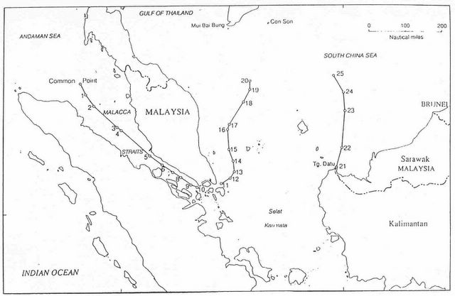

Figure 3.a Indonesia-Malaysia Maritime Boundaries


Maritime Boundary in Celebes Sea: Status and Problems
According to Villanueva (2005), the overlapping claims of territorial sea boundary, EEZ boundary and Continental Shelf boundary around Ambalat area or Celebes Sea have not yet been fully agreed. These have to be established through a bilateral negotiation between Indonesia and Malaysia. Jinangkung (2005)7 stated that Indonesia is actually ready to conduct any negotiation and even already started the negotiation on 22 March 2005 with Malaysia. Even though it seemed to be related to Ambalat case, he asserted that the negotiation was a scheduled negotiation and would generally discuss Indonesia-Malaysia unresolved boundaries in the three locations: Malacca Strait, South China Sea and Celebes Sea.
Ambalat
Many people do not precisely aware the position of Ambalat. Some even do not realize that Ambalat is not an island but water area/block located in the east of Borneo. Besides Ambalat, the block is also known as Block ND6 and ND7.
According to discussion on this matter in an internet-based community, RSGIS Forum, Ambalat is a block located in the area with coordinates of 118°15'21" - 118°51'15" E and 2°34'7" - 3°47'50" N. Having assumed that the coordinate is accurate, Ambalat lays from South to North at a distance of 65 km and 135 km from West to East. This also means that the block situates bellow the border line crossing Sebatik Island. Relative to Sipadan and Ligitan, Ambalat situates closer to Borneo. Two figures bellow respectively show the location of Ambalat and its position relative to Sipadan and Ligitan.


It is worth noting that the ICJ’s decision to grant Sipadan and Ligitan to Malaysia may change the configuration of Malaysia’s baselines. This can influence maritime zone it may claim. In the other words, it is highly possible for Malaysia to claim larger maritime zones southward to Indonesia. This, according to some sources, is one of the strengths for Malaysia to claim Ambalat.

Conflict Resolution: A Rough Idea
As previously mentioned, a bilateral mutual agreement between Indonesia and Malaysia is required to resolve conflict on boundary case. It is obvious that Ambalat case is a maritime conflict because Indonesia and Malaysia claim the same maritime zones (overlapping claim) where the block situates. Villanueva (2005) asserted that this is not the case of full sovereignty but limited sovereignty to explore and exploit maritime zone and natural resources deposited there. This is different compared to the case of the ownership of an island.
Before deciding to start a negotiation, Indonesia obligates to conduct comprehensive studies, which technically has to be initiated by the National Coordinating Agency for Surveys and Mapping (Bakosurtanal) and The Indonesian NAVY’s Hidro-Oceanographic Office (Dishidros TNI-AL) with coordination with the Department of Foreign Affairs.

Following are technical steps that might be considered in resolving Ambalat case.
  1. Baselines Definition
    It has to be anticipated that Malaysia may change its baseline configuration because Sipadan and Ligitan are now officially theirs. Defining Indonesia and Malaysia’s baseline in Celebes Sea is the first step to do as reference for measuring maritime zones. Indonesia, will, of course, preserve its archipelagic baselines.
  2. Definition of EEZ and Continental Shelf Boundary
    The second step is to define the boundary for EEZ and Continental Shelf. It will be found that Ambalat situates in EEZ and Continental Shelf of both States. The case deals with Continental Shelf since it relates to the exploration and exploitation of seabed.

  3. Maritime Boundary Delimitation
    The overlapping claim in the EEZ and Continental Shelf requires maritime boundary delimitation. It has been widely accepted to employ equidistance/median line to generate a boundary line, at least as a starting point. After that, it needs to consider contributing factors/aspects to achieve an equitable solution. Factors that need to be considered are proportion of coastal length involved, and socio-economic development of both sides.

  4. The possibility to establish Joint Development Area
    If the delimitation divides Ambalat into two different parts, each country can only explore and exploit its own part. Another possibility is to establish a Joint Development Area, similar to what agreed by Indonesia and Australia in the Timor Gap. The urgent matter that needs to agree upon is the management and sharing rules for each side.

Technical steps described above can be done by employing in situ survey or cartographically using nautical chart and satellite image in a sufficient scale.

Closing Remarks
Having considered the above analysis, it can be concluded that:
  1. Ambalat case is a limited sovereignty conflict because both Indonesia and Malaysia try to claim the same maritime zone (overlapping claim).

  2. A good understanding in term of science, technique and law is essential, not only for government officials but also ordinary people from both sides, to avoid emotional decision.

  3. This requires synergy among related departments, agencies, boards, etc. to comprehensively study the case before deciding to negotiate the case bilaterally or submitting the case to the International Court of Justice.

The case involving Sipadan, Ligitan, Ambalat and other similar cases related to International Boundary should have reminded Indonesia, as a nation, to seriously pay attention to maritime boundary delimitation. Another urgent step is to list small islets all over Indonesian Archipelago, and to name (toponim) every single islet. This, actually, has been conducted by the Department of Marine Affairs and Fisheries since quite a long time. To speed up the process, as opined by Wikantika (2005) Remote Sensing technology can be employed using satellite images. By finishing these all urgent “homework”, hopefully Indonesia gains more strength to preserve its sovereignty and can negotiate confidently whenever a case regarding maritime boundary arises.

Footnotes

1Delivered in an open discussion by Indonesian Students at UNSW, Sydney, 29 March 2005
2A Lecturer at Department of Geodetic Engineering, UGM, currently studying technical aspect of International Maritime Boundaries
3see also http://www.icj-cij.org/icjwww/ipresscom/ipress2002/ipresscom2002-39_inma_20021217.htm about the ICJ’s judgment on this case
4Detail regulation for each maritime zone can be found in UNCLOSS III document. Online access: www.un.org/Depts/los/convention_ agreements/texts/unclos/unclos_e.pdf
5Three types of baselines: normal baseline, straight baseline, and archipelagic baseline. The last type is applicable to Indonesia because it is an archipelagic state.
6Datum is a reference position for an object on earth. A map must have an official datum and is scientifically acceptable in an area. Two maps used together for common purpose must have the same datum.
7L. Amrih Jinangkung is a staff of the Indonesia’s Department of Foreign Affairs, Directorate of Treaties on Political Security and Territorial Affairs. Communication with author was done by email.

References
Forbes, V. Louis, (2001), Conflict and Cooperation in Managing Maritime Space in Semi-Enclosed Seas, University of Hawaii Press
Prescott, Victor (2004), Maritime Delimitation in Southeast Asia: The Case of Indonesia
Schofield, C. (2003) Maritime Zones and Jurisdiction, 2003 ABLOS Conference, available: http://www.gmat.unsw.edu.au/ablos/ABLOS03Folder/SESSION3.PDF
Syarif, Laode M., (2005), Pesan buat Syed Hamid Albar, Kompas,12 maret 2005
Tarmansyah, Umar S., (2003), Lepasnya P. Sipadan Dan P. Ligitan Sebuah Pelataran Kewaspadaan, Buletin Balitbang Dephan No 10
Villanueva, Klaas J., (2005) Satu Pandangan/Ulasan: Sengketa Wilayah ZEE Dan Wilayah Landas Kontinen di Ambalat
Wikantika, Ketut, 2005, Mereinventarisasi Pulau-pulau Terluar Indonesia Citra Satelit Kurangi Biaya Survei, Pikiran Rakyat, 17 maret 2005

More...

Wednesday, March 23, 2005

SSDS March 2005

Staff-Student Development Seminar is a regular program organized by the School of Surveying and Spatial Information System of UNSW. Today, It was my turn to present my research to the group. Below are my slides:


More...

Tuesday, March 08, 2005

Ambalat, What's Up?

I Made Andi Arsana1

Introduction
Malaysia’s decision to award a concession for oil exploitation and management in the Ambalat area to the Royal Dutch Shell and other company last February raised reactive response from Indonesian government and people. The decision indicated that Malaysia was definite that Ambalat is part of its territory. Meanwhile, Indonesia is also confident that the area is its. This is supported by historical facts that Ambalat, previously, was part of Bulungan Sultanate, which, since Indonesian Independence has been part of Indonesia. This opinion is known as the chain of title argument.

Reactive responses from Indonesian government and people were understandable since Indonesia is not yet recovered from trauma when International Court of Justice decided to awarded Sipadan and Ligitan to Malaysia after a long complicated legal process. Apparently, Malaysia is trying to push its luck by claiming another area; Ambalat. That is what most Indonesian people think. Even though, historically, these two islands were also part of Bulungan Sultanate, at last Malaysia won the case and became the legal owner of them. The decision by the ICJ was based on (one of them) the argument that Indonesia failed to prove that it did enough to maintain the environment of those two islands (www.media-indonesia.com, 4 March 2005). Will the oily-rich Ambalat suffer the same and follow its two “big brothers”, Sipadan and Ligitan? It seems to me that Indonesian Government has to fight extra strongly and extremely carefully dealing with this particular problem.

Indonesia-Malaysia Boundary and the 1891 Convention
To resolve the overlapping claims, it is necessary to look back to the series of negotiations that have been done between the two States, in relation with International Boundary at Borneo Island which was actually started in 1974 (according to Indonesia’s Department of Foreign Affairs). It is well-known that Indonesia-Malaysia Boundary located in the Celebes Sea, where Ambalat located, has not been fully established. The incompleteness has actually given one loss to Indonesia, when Malaysia won Sipadan and Ligitan.

Should an explicit agreement about Ambalat ownership has not been achieved, it is necessary to reconsider the 1891 Convention between The Great Britain ant The Netherlands, the two countries governed Borneo during the colonial era. This convention, for sure, is one of the main legal references in defining the boundary between Indonesia and Malaysia in Borneo. An intensive investigation needs to be done to confirm whether the convention explicitly governs the ownership of Ambalat. This is, analogically, similar to the use of Treaty 1904 for the delimitation of Indonesia and Timor Leste land boundary.


http://images.modblog.com/files/mbgallery/beeography/files/ambalat_banner1.jpg


Chart Recognition
As informed by some news (e.g. detik.com, 02-03-05, kompas.com, 08-03-05), Malaysia uses its 1979 chart to claim Ambalat. With regards to this chart, Prescott (2004), an international maritime boundary expert, stated that the chart also contains a continental shelf boundary claim, where the claim “lies beyond the median line along its entire length. The maximum deviation in two sectors is about 5 nm. It appears that in constructing this seabed claim Malaysia has undervalued some legitimate Indonesian baseline points.”
Despite the above view, it is necessary to systematically investigate how a chart can be recognized and used as a legal basis to claim certain area. Clive Schofield, a former director of the International Boundary Research Unit (IBRU) said that “certain charts are supposed to be deposited with the UN (e.g. charts showing certain types of baselines and maritime boundaries). However, in this case one State issuing a chart can't be binding on another State unless that State agrees so. There is the possibility that over time a State may acquiesce to a particular situation but that doesn't, at first glance, appear to be the case here.” This implies that the use of 1979 chart by Malaysia must be aligned with acceptable scientific and legal considerations. If the chart fulfils only partial needs and interest, disregarding other State’s sovereignty, it cannot be used that way.


Conflict Resolution
Unfortunately, as one of the main legal references, the 1891 Convention apparently will not help much in resolving the problem. Similar to Sipadan and Ligitan, the convention seemingly does not firmly govern the ownership of Ambalat. This is because the 1891 Convention only states that the Great Britain and the Netherlands agreed to admit the boundary line that reaches the east coast of Borneo. Article IV of the Convention stipulates, "allocation of the adjacent area shall follow the line of 4° 10’ latitude, proceeding in an easterly direction across the Island of Sebatik." It does not further explain the continuation of the line in question. This, of course, does not help as Ambalat, just like Sipadan and Ligitan, situates eastern of the end point of the line. If the line was simply elongated eastward, it is clear that Ambalat will be part of Indonesian territory. However, elongating the line without a clear and strong legal basis cannot be easily accepted.

With regards to the above view, a bilateral diplomacy is apparently the most probable recourse. Even though submitting such case to an international body, e.g. ICJ, is a good alternative to some extents, it is not always recommended. Base on Prescott’s ideas, there are three reasons why this is not preferable. First, such case always seem to last at least 4-5 years, meanwhile continued bilateral negotiations might be productive. Besides, this will also cost a huge amount of money. Hasan Wirajuda admitted that Indonesia spent approximately Rp 16 billions for the case of Sipadan and Ligitan (Tempo, 23 December 2002). Second, sometimes Courts produce surprising results. The Gulf of Fonseca judgment was such a case. First it found that historical bays could be shared by two or more states. Second it allowed, Honduras, which is clearly locked within the Gulf by El Salvador and Nicaragua, to claim seas and seabed in the Pacific Ocean. Third sometimes the Court’s reasons for making a decision are obscure.

The Next Steps
Indonesian Government should take some significant learning experiences from this case. The case should have encouraged government to realize the importance and urgency of international boundary delimitation, maritime boundary, in this case. This is not only with Malaysia but also with all neighbouring States. Indonesia currently has 10 incomplete maritime boundaries with neighbouring States. They are with Malaysia, Philippine, Palau, India, Thailand, Timor Leste, Singapore, Papua New Guinea, Australia, and Vietnam. It is understandable that it is such an overloaded period since Indonesia is currently facing some huge problems, including tsunami and other natural hazards that require intensive attentions. This is the time that government is really challenged to keep paying attention to such an important issue i.e. international boundary, while at the same time bombarded with unexpected natural hazards.

Another urgent step is to list small islets all over Indonesian Archipelago, and to name (Toponim) every single islet. This, actually, has been conducted by the Department of Marine and Fisheries since quite a long time. This apparently needs more, “energy” to speed up the process. If Indonesia fails to do this, its thousands of islands and islets will be gone one by one, claimed by other states without any significant defence.

It is worth noting that having only history and legend is not enough to investigate ownership on an area. The loss of Sipadan and Ligitan is one of the cases. It is required that Indonesia has legal evidence indicating it has administered the territory in question. According to Schofield, “many ways to do this but, for example, collecting taxes from the population living there, issuing domestic legislation, etc”. The development of tourism resorts in Sipadan and Ligitan is one of the factors that would the lead Malaysia into a victory over Indonesia, beside the issue of environmental management.

Closing Remarks
It does not matter what technical procedure Indonesia and Malaysia will employ to resolve the problems, both have to respect each other by attempting peaceful ways in negotiation. A good understanding in scientific, technical and legal aspect on both sides, will most probably reduce provocative decisions. This must also be understood by ordinary people in both States, to be able to support the establishment of a fair resolution.
This writing will not be here without significant help from some colleagues. I personally acknowledge Clive Schofield and Karin Johnson for assistance they provide.

1A researcher in the Centre for Boundary Research UGM-Bakosurtanal, currently a research student at UNSW, Sydney, Australia

More...

Sunday, March 06, 2005

CARIS LOTS training


Certificate!

More...

Monday, December 20, 2004

Letter to AusAID for Software Training

20 December 2004

Jo Ronalds
UNSW AusAID Liaison Officer


Dear Jo,
I am writing with regards to my plan to attend a software training conducted by my school, the School of Surveying and Spatial Information Systems, UNSW on February 21 – 25, 2005. The training is about the application of CARIS LOTS™ (see http://www.caris.com/products/product.cfm?productID=15) in maritime boundary delimitation. My school will invite a professional trainer from CARIS (http://www.caris.com), Canada to provide a tailored training, which will be open for public.

As you might know, my research is about the delimitation of maritime boundary between Indonesia and Timor Leste which will use the above mentioned software to generate the boundary lines. As the software is a new kind of software to me, it is clear that the training will be essential to accomplish my research. In addition, the training will be the first CARIS LOTS™ training conducted in Australia. For sure, it is going to be a good opportunity for me.

As part of the scholarship agreement, I kindly request AusAID to support me to attend the training by providing funds for the registration. Enclosed is an email from the trainer containing training details. A recommendation letter from my supervisor, Dr C. H. Schofield will be sent to you separately by email.

Thank you very much for your attention and cooperation. I am looking forward to hearing from you in the near future.

Yours sincerely,


I Made Andi Arsana
Student ID: 3082390

More...

Response from Bakosurtanal

[calling pak sobar]

I haven’t mentioned that I got response from Bakosurtanal, have I? Bakosurtanal is an important institution I will visit during the fieldwork. I called Dr Sutisna (hereinafter referred to as Pak Soabar), head of the center for Boundary Mapping of Bakosurtanal. He answered my called warmly with his friendly “assalamualaikum”. Without doubt, I simply replied “walaikumsalam” followed by introduction. It did not take long for him to remember me when I said “Madé UGM”. He just did not realise that I called from Sydney because the strange number appeared on his mobile was [like] a Jakarta number.

Pak Sobar responded positively when I told him my plan to visit Bakosurtanal for obtaining data (topographic map). Only, he will not be around at the day (24-26 January 2005) for he will be in Mekah for “Ibadah Haji”. It doesn’t matter because, according to him, Bu Sari can help me to obtain the data. “Just lest us know your detail plan and data you need, Bu Sari will help you. You’ve known her haven’t you?”, he added.

I hope this journey can enrich my academic experience as well as strengthen the network I am currently developing.

More...

Friday, December 10, 2004

One hour with Hasanudin Z. Abidin

[six-point suggestions]

Today, I have a chance to talk to Hasanudin Z. Abinin, the top-notch GPS guy from Indonesia. He was also one of the key persons who have conducted preliminary research on maritime Boundary delimitation between Indonesia and Timor Leste. I just “use” the chance to talk to him while he is visiting our school for the GNSS 2004 conference.

Hasan emphasized at least six (6) items I have to consider:

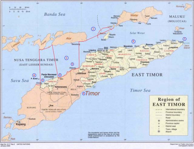
  1. The effect given to the small island (Kisar) that belongs to Indonesia located up-right of Timor Island. According to Hasan, it is possible for TL to ask Indonesia to give a half (or even less) effect to the island because it is very small compared to the whole TL. However, it is also possible for Indonesia to negotiate because the island should not be compared to the whole TL but to a similar island belongs to TL (Jaco) which is located near the island in question. If TL insists to consider the whole TL, Indonesia can argue to consider the whole Indonesia as well, which is undoubtedly, significantly larger than TL.

  2. The baselines pulled from Liran Islet (or island) which is located at the west of Wetar Island to Alor Island can be the part of archipelagic baseline which technically is straight baseline. However, it is not possible because it will cross the Internal Water of TL because one of TL’s islands, Atauro, which is located between Liran and Alor, will generate its own maritime zone. Concerns need to be given to this particular case.

  3. With regards to Oekusi, it will be difficult for Indonesia to draw baseline. According to Jalal, Indonesia is entitled to draw archipelagic baseline which is closed. This means Indonesia can pull the line from a point at Alor Island to one of common basepoints located at Timor Island, somewhere in the land borderline between Atapupu and Balibo and continue it along the coast until Wini. From the point the line can be drawn up to a point at Alor Island, continued to Pantar Island and down again a point at Citrana (see red line in the figure bellow). Jalal claimed that it is possible to draw such a line because, as mentioned previously, archipelagic baselines should be closed and the straight sections it produces do not exceed the limit, 125 n.m.

  4. The ownership of Batek Island. Orally, TL admitted that Batek belongs to Indonesia but when Indonesia asked TL to state it formally, TL refused it. The ownership of Batek Island will significantly influence the definition of maritime boundary because Batek, as an island, can generate its own maritime zone.

  5. The definition of Common Basepoints. Indonesia has defined its basepoints and those are regulated by PP 38/2002. However, the regulation does not include common basepoints. This research must simulate the location of common basepoints base of the rule and constraints in defining basepoints.

  6. TL basepoints. TL has not yet its basepoints along the northern coast. This means that to be able to draw the boundary line, it is necessary to define TL’s basepoints.


Adapted from: http://www.defence.gov.au/army/asnce/images/timor_map.jpg

More...

Monday, November 22, 2004

Excellent!

[Chris's supports]

I met Chris today after previously canceling two appointments with him.
Basically we discussed my proposal and the plan to conduct fieldwork in Indonesia. Chris gave a very encouraging comment concerning my proposal. He confirmed that I've covered everything perfectly in the proposal that impresses him.

Chris paid attention to the section explaining the Geographic Information Systems and he suggested me to come to Canberra to visit the Australian Maritime Boundaries which is part of Geoscience Australia. He was sure that I can see much things related to the application of GIS in Maritime Boundary. What the group has done, will enrich my insight about how GIS is used in managing Maritime Boundary data. I will ask Clive to take me there whenever he comes there to see one of his PhD students.

I personally asked Chris whether I can start writing a paper related to my research and publish it in a journal or conferences. He supported me to do so, but he does not know much what I can write in the law of the sea topic and where I can publish it. For this reason, he suggested me to discuss with Clive. He prefer me to write a paper about the application of GIS in Maritime Boundary. Shortly, he encouraged me to write something related to Geomatics and he will support me to publish it in a converence or journal.

We also discussed posibilities to extend my study into a PhD level and he told me that there are two possibilities. Firstly, if possible, I can transfer my study from master level into PhD level by adding one or two more years of study period. This means that I will not get Master degree, but only PhD. Secondly, I have to finish my master first and then start to develop a new proposal for PhD. In this case, the topic must be completely different. However, Chris asked me to talk furher about this particular matter to Clive. He thought that Clive might know better then him concerning the topic and its adquacy to proceed a PhD level.

Despite all the talks about study and extensions, money does matter. To find a sponsorship is another problem I should deal with.

Anyway, I am really happy with Chris's response today. I am sure that his positive comments and supports will help me much in accomplishing the research.

More...

Friday, November 19, 2004

Response from National Archives

Similar to DEPLU and Dishisdros, the National Archives of Indonesia also gave a positive response to my plan doing research there. They also expected me to provide a letter addresed to the section of Archive Service.

More...

Yes, that is what experts call "Normal Baseline"

Finally I've managed to finish all the "dispute" about NORMAL Baseline. Figure in entry on November 4, 2004 is the correct Normal Baseline. Clive also confirmed that the picture looks nice and correctly depicts the baseline.

It is important to understand some terms:
* Low Water Elevation
* Low Water Line

Please see here for details.

More...

Wednesday, November 17, 2004

Fieldwork or holiday?

I am so happy today.
My journey to Jakarta will enable me to stop over in Bali for one night. This is because the flight to Jakarta will be through Denpasar and it is possible to stop over. However, I need to pay $55 for that because AusAID does not provide funds for 'holiday' but It doesn't matter.

I've confirmed my flight schedule to STA and the following are the details:

  1. 15 January 2004 -> Sydney to Denpasar
  2. 16 January 2004 -> Denpasar to Jakarta
  3. 7 February 2004 -> Jakarta to Yogyakarta
  4. 14 February 2004 -> Yogyakarta to Denpasar
  5. 18 February 2004 -> Denpasar to Sydney


More...

Saturday, November 13, 2004

Response from DISHIDROS

[thanks to Mas Yazid]

I finally know that there is an Alumny of Geodetic Engineering in DISHIDROS. His name is Mamad Yazid who entered UGM in 1988. He personally supported me to conduct fieldwork in DISHIDROS and promise me to give any data I need.
Because of our personal relationship, he even did not request me to provide a formal letter. However, I think it is agood idea to have one and Clive already agreed to write a letter for me.

More...

Friday, November 12, 2004

My Fieldwork Approved!

An email from Jo:

Dear Andi

Thank you for your email.

Today a letter approving your fieldwork was mailed to you. I have provided
STA with a copy of the letter, and your schedule so that they may make the
booking. I have also asked that the most flexible ticket possible be
booked for you. I would recommend that you contact them next week to
confirm the details of the booking.

In regard to your training, the same documentation is required as
previously requested.

Kind regards
Jo

More...

Thursday, November 11, 2004

CARIS training on February 2005

Finally, we've come up with a solution.
The training will be held on February 2004 after the fieldwork. We plan to do it on February 21-25, 2005. Hopefully, no obstacle raises.

See you next year!

More...

Wednesday, November 10, 2004

Respons from DEPLU

[thanks to Mr. Jinangkung]

I've tried to contact The Department of Foreign Affairs of Indonesia for the fieldwork. Positively, Mr Amrih Jinangkung gave a response and told me to prepare a letter. There, I will be dealing with the Director-General for Multilateral Political, Social and Security Affairs of the Department of Foreign Affairs.

Amrih also indicated that his directorate might not be able to provide all data I need but he promise me to introduce me to other sections which probably can support my research. He also adviced me to provide a short letter signed by Clive saying that I am a research student at UNSW and need to do research at the Department of Foreign Affairs.

For communication purposes, Amrih can be contacted by email aung01@hotmail.com or telephone +62213849618.

More...

Friday, November 05, 2004

CARIS LOTS training - rescheduled!

I've got an email from Clive:

=================
One hitch is that Rob van de Poll has now said he cannot do the dates we discussed. I am therefore thinking about the second week of January (i.e. just before you plan to go away on the 15th). Would that be OK with you?
=================

bellow is my reply:

=================
I am afraid, may not be available on the second week of January. I
plan to go to Brisbane for vacation and I've booked tickets for us
(Asti and me). How about doing it earlier, let's say on the first or
second week of December?

Or, if it is not possible at al, I will cancel my ticket. I don't
think we have other way out, do we?
=================

More...