
On Sept. 26, 2005 Antara official news agency carried a report on the concerns of a North Sumatra's provincial legislator regarding a website promoting Pulau Berhala as one of Malaysia's tourist destinations. When reading this, Sipadan and Ligitan come to mind. The two islands were secured by Malaysia when the International Court of Justice (ICJ) ruled that sovereignty over them rested with Malaysia in 2002.
In Indonesian minds this scenario raises disturbing questions: Is Malaysia now pushing its luck and seeking to secure small, isolated islands in boundary areas one by one? Is Pulau Berhala vulnerable and could there be a repeat of the Sipadan and Ligitan case? Read more...
 Karya I Made Andi Arsana, ST., ME
Batas Maritim Antarnegara - Sebuah Tinjauan Teknis dan Yuridis
(Gadjah Mada University Press, 2007) more...
Karya I Made Andi Arsana, ST., ME
Batas Maritim Antarnegara - Sebuah Tinjauan Teknis dan Yuridis
(Gadjah Mada University Press, 2007) more...Monday, October 31, 2005
Berhala in the JP

Saturday, October 01, 2005
Berhala: Another Sipadan and Ligitan?
The news in ANTARA on 26 September 2005 was about the concerns of North Sumatra’s FPPP provincial legislative councils regarding a website promoting Pulau Berhala as one of Malaysia’s tourist destinations. This was addressed by Fadly Nurzal, a representative of FPPP. When reading this, Sipadan and Ligitan come in mind. The two islands have been secured by Malaysia as the International Court of Justice (ICJ) decided to award their sovereignty to Malaysia in 2002. Does Malaysia push its luck to secure one by one small islands in the boundary area? Will Pulau Berhala repeat the history of Sipadan and Ligitan? Let’s see what happens!
As far as I am concerned, there are at least three different islands called Berhala. The first island is the one referred by Nurzal in Malacca Strait, around 48 Nautical Miles from Port Belawan. The second Berhala is in Berhala Strait close to Riau Archipelago that has been a source of conflict between Jambi and Riau for such a long time. The last one is close to Sandakan, North Borneo, which has been a tourist destination and is fabulous for diving. The second Berhala is clearly Indonesia’s, while the third one is definitely Malaysia’s.
Unfortunately ANTARA did not clearly mention the website referred by Nurzal. Therefore it is not a hundred percent clear which Berhala Malaysia promotes as its tourist destination. If the island it promotes is the one close to Sandakan, Nurzal must have been careless in expressing opinion. Hopefully that is not the case.
If Pulau Berhala in question is the one in Malacca Strait, then it will be a different story. Indonesian government has to pay extra attention as this may lead to the loss of an island. Pulau Berhala, as stated by the Hidro-Oceanographic Office of the Indonesian Navy (Dishidros), is one of the 12 small islands which are critical due to their position in the international boundary area.
The other eleven islands are Pulau Rondo (Indonesia-India); Pulau Nipa (Indonesia-Singapore); Pulau Sekatuang (Indonesia-Vietnam); Pulau Marore, Pulau Mianggas and Pulau Marampit (Indonesia-Philippine); Pulau Batek (Indonesia-Timor Leste); Pulau Dana (Indonesia-Australia); Pulau Fani, Pulau Fanildo, and Pulau Brass (Indonesia-Palau).
Let’s look closely to Pulau Berhala in Malacca Strait and review the maritime boundary agreement between Indonesia and Malaysia.
In 1969, Indonesia and Malaysia entered into an Agreement dividing the continental shelf between the two countries in Malacca Strait and ratifications were exchanged on 7 November 1969. Ten points are agreed as the turning points of the boundary line.
Some opined that the agreement is not an equitable solution as Malaysia applied straight baseline connecting its outermost islands while it is not an archipelagic state. This causes the boundary line lies closer to the Indonesian side and is considered as inequitable. However, Indonesia and Malaysia have signed the agreement and it has been binding for both countries for such a long time. Now, it is not important to discuss how the boundary has been achieved but to obey the agreement, unless the boundary needs renegotiation.
Unlike the uncertainty of Sipadan and Ligitan as there has been no definite maritime boundary in Celebes Sea, the continental shelf boundary in Malacca strait should have made the status of Pulau Berhala clear. Based on the 1969 agreement, the International Boundary Study of the Department of State, US analyzed the boundary and found that Pulau Berhala belonged to Indonesia. This was clear in the analysis of the study, especially in the table of characteristics of the border points (The Geographer, 1970).
Experiences tell that the arguments of chain of title based on the history are often not strong enough to prove the ownership an island. Indonesia or Malaysia could refer the history to prove that an island belongs to it but often it is hard to agree. This is because there is no dateline since when such history should be considered. This was also the case when the ICJ decided the case of Sipadan and Ligitan by considering the principle of effectivités. Historic arguments proposed by Indonesia and Malaysia could not convince the court and were rejected. The principle of effectivités looks more to the effective legal action done by countries in question to the islands. The court found that Malaysia, proceeded by the Great Britain, have done much more to maintain Sipadan and Ligitan Islands. Therefore the "sovereignty over Pulau Ligitan and Pulau Sipadan belongs to Malaysia”
In the case of Pulau Berhala, we will also assess the principle of effectivités and see how it goes.
In 1984, Indonesian Government built a lighthouse in the Island and since has been maintaining the lighthouse by continually assigning lighthouse attendants. This can be considered as a legal action proving that Indonesia has done the appropriate things as the owner of Pulau Berhala. Maintenance of the lighthouse requires Indonesian Government to take care the environment; otherwise the lighthouse will not be able to function properly. This also proves the role of the Indonesian Government in Pulau Berhala fulfilling the principle of effectivités. Therefore, based on the principle of effectivités, Indonesia deserves to be the legal owner of Pulau Berhala.
In a technical perspective, a spatial assessment needs to be done by plotting the coordinate of Pulau Berhala together with the border lines in an appropriate-scaled nautical chart. By plotting the location of Pulau Berhala and the boundary line in a chart, it will be clear whether Pulau Berhala lies in the side of Indonesia or Malaysia.
We will see how Indonesia and Malaysia deal with this kind of problem. It is very important for all citizens to clearly understand the problem and support the governments to do their best. Instead of being over-reactive, let’s be calm and patient.
Tuesday, September 27, 2005
Indonesia Council Open Conference, 2005
[Adelaide, 26-27 September 2005] Being the only surveyor presenting in a social science conference is an interesting experience. The Indonesia Council Open Conference, 2005 is an annual conference hosted by Flinders University in Adelaide with the support of The Flinders Asia Centre and the Inside Indonesia magazine, where my presentation is the only technical paper among many social papers presented. Being a social science conference, almost all presentations are about to social issue, especially, of the Indonesian society.
The topics presented were vast and diverse from the literacy issues to Indonesia's future. Most of the topics might not be interested for a surveyor/geodesist. Therefore it is not important to discuss each topic here.
I presented my paper, "Maritime Boundary Delimitation between Indonesia and Timor Leste: A Technical Perspective", on 26 September 2005 in the session of Boundaries, migration and foreign policy. Being the only technical paper, the presentation attracted intention form most audiences and also drew some interesting questions and comments. Different from the other presentation which were filled with words, my presentation was dominated with graphics and pictures [maps]. All the technical aspects I introduced coupled with legal consideration [law of the sea] in defining maritime boundaries were quite interesting to the audiences. This, I belive, was a good moment to remind them surveryor's contribution to such an international matter (i.e maritime boundaries).
A senior lecturer from Deakin University, Dr. Damien Kingsbury gave very good comments and suggestions regarding my research, as he significantly knew East Timorese views about the maritime boundaries in question. He also promised to introduce me to an East Timorese geographer who is currently dealing with the Boundary issue. This will be a very good information resource.
To sum up, apart from the fact that the conference is more about social science, it was still a very good event to share ideas, especially to enrich the resource of my research as a multi-disciplinary one.
For more information please visit the website. Please also contact me for a proceeding containing colection of abstracts.
Tuesday, September 06, 2005
Giving a Lecture in Wollongong University
Surprise!!!

The students are all Indonesians from [nearly] all around Indonesia. Some of them are from Department of Fisheries and Marine Affairs, while some others are from Regional Governments.
They looked very entusiastic listening to my lecture about Indonesia's Internal Boundary Issues. It was understanable as it was the only lecture in Bahasa Indonesia. A student, jokingly, said that my lecture is the only lecture he can understand, making his colleagues laugh.
It was a very good experience! More...
Sunday, September 04, 2005
Indonesia Council Open Conference 2005, Monday 26-27 September 2005, Adelaide

Chris, my supervisor, generously provides economical return flight ticket for the conference. I Thank him very much for his generousity.
The news/add for the conference has been posted in the South East Asia times website at the left sidebar.
Sunday, August 28, 2005
Map Asia 2005, Jakarta 22-25 August 2005
[an epilogue]
 Map Asia 2005 is the 4th annual conference organized by GIS Development PTE. Ltd. - Singapore in collaboration with Indonesia’s Bakosurtanal, Asosiasi Perusahaan Survey dan Pemetaan (APSPI ) – INDONESIA, Center for Science, Development and Media Studies (CSDMS) - India,and the Asian Institute of Technology - Thailand. The conference was undertaken in Mulia Hotel, Jakarta Indonesia on 22-25 August 2005. Bellow are some important notes about the conference.
Registration and Opening Ceremony
The registration started at 10 am and ended at 4 pm when the opening ceremony began. The conference was officially opened by The Indonesian Minister of Research and Technology, DR. Kusmayanto Kadiman, who is an alumnus of the Australian National University. Other speeches were also delivered by The Head of Indonesia’s Bakosurtanal (MR. Matindas), the president of Map Asia 2005 (Prof. Narayanan), and local organizing committee (Mr. Purnawan).
Hitting the “Gong” officially inaugurated the conference and all its programs including exhibitions, technology shows, and workshops. The ceremony ended with an inaugural dinner in the Grand Ball Room of Mulia Hotel.
Plenary and Keynote Sessions
The first day [23 August 2005] started with plenary session I: empowering People through Geospatial Information with three speakers. This was followed by keynote session I : Web GIS with also three speakers. The second day [24 August 2005] has one plenary session and one keynote session with total of 5 speakers. The plenary session was on Regional Cooperation while the keynote session is about Large Scale Mapping. In keynote session, speakers excessively discuss the advance in large scale mapping and the availability of large scale data in the internet. Google Earth was one of the phenomena that discussed a lot.
Seminar Sessions
There were three seminar sessions in the conference. I presented my paper in one of the seminar sessions: Marine and Coastal GIS which was chaired by Drs. Michiel Damen from ITC, the Netherlands. My paper is “Ambalat: A Spatial and Technical Perspective”, penned with Clive Schofield of The University of Wollongong. Other seminar sessions are Space Program and RS, and Disaster Management distributed in some parallel sessions. That is why, it was impossible to attend all presentations as some are delivered at exactly the same time.
Technical Sessions
This consists of 16 sessions: Geological Applications; Water Resources; Land Information System; Open Geospatial Consortium workshop on interoperability; Disaster Management; Traffic and Transportation; Precision Farming and Agriculture; Environment and Forestry; Urban and Town Planning; Digital Image Processing; Web GIS/Internet GIS; Photogrammetry and 3D Visualization; Database Design and Ontologies; Land Cover, Use and Change; Emerging Applications; Natural Resource Exploration and Planning. Similar to seminar session, this session was also distributed into some parallel session in different venues, so visitors had to decide which presentation to attend.
Networking
The Conference, to me, was a very good event where we could start building international networking among experts, industries and users of geospatial technology. Some opportunities were available such as software share, training, data exchange, collaborative research, etc. Some industries even freely distributed data, software, magazines and books to exhibition visitors.
More Information
For more information, please visit www.mapasia.org. Proceeeding CD and abstracts collection are available. Please contact me for a copy
Sunday, August 14, 2005
Map Asia: just a few days to go!
Just checked the website of Map Asia 2005, the organiser has set the schedule for presentation. As promised, I will be presenting in the sesion of Marine and Coastal GIS on 25 August 2005.
I have finished my presentation slides and am currently practising for presentation. It will be my first presentation in an international event, I need to prepare better. The presentation should be using a clear and good English as well as efficiantly using the time given. Right now, I am checking the time usage in presentation.
Thursday, August 11, 2005
UNCLOS III Visualuzation
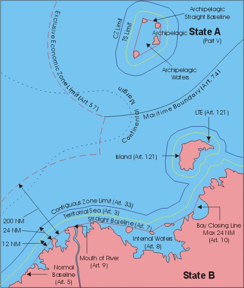
Visualization of the United Nation Convention on the Law of the Sea 1982
Monday, August 01, 2005
Timor Leste vs Australia
It has been widely known that there is 'something' in the Timor Gap that attracts Timor Leste, Australia, and even Indonesia for such a long time.
The interactive map bellow illustrates the location of the desputed area regarding maritime boundary between Timor Leste and Australia, which previously known as the Timor Gap. Please click on the number icons at the bottom left of the map to see more information.
Please note that you need to have Flash installed in you computer, as this posting has a flash animation graphic.
taken from http://www.timorseajustice.org
Thursday, July 14, 2005
Excercising Maritime Boundary in Timor Sea
Robust Equidistance Line
Figure bellow depicts equidistance lines in Timor Sea that consist of two different segments. Segment CB4-a is the adjacent equidistance line between West Timor and Timor Leste, and is the elongation of land border in Mota Masin. Segment b-c represents the median line between Timor Leste and the Indonesia’s archipelagic straight baseline along Pulau Leti, Pulau Moa, Pulau Lakor, Pulau Maetimearang with zero effect given to Pulau Jako. On the other hand, segment b-d is similar to segment b-c only with full effect given to Pulau Jako.

Final Boundary Line
To finalize the boundary in Timor Sea, especially the one starting from the point between Pulau Jako and Pulau Leti going down to the boundary between Indonesia and Australia, half effect has been given to Pulau Jako. The blue line between two black lines is the final boundary line in Timor Sea at the East side. Meanwhile, the equidistance line departing from Mota Masin at the West side of Timor Sea has been left without any shift. This is because there is no significant feature to consider and neither relevant circumstance that influence the equidistance line. The following Figure shows the final boundaries in Timor Sea.

Excercising Maritime Boundary in Ombai Strait
Robust Equidistance Line
Equidistance lines in Ombai Strait shown in figure bellow consist of four segments. The first segment is the line starting from common basepoint CB1 to point a, which represents the equidistance line between Oecussi and West Timor as the elongation of land border in Noel Besi. The second segment is the a-b segment, representing median line between Pulau Batek and Oecussi with full effect given to Pulau Batek. Segment b-c is the median line between Oecussi and Indonesia’s Pulau Pantar and Pulau Alor. Similar to the first segment, the last segment of c-CB2 is the equidistance line between Oecussi and West Timor, as the elongating of land border in Noel Meto.

Final Boundary Line
The maritime boundary in Ombai Strait, as depicted in figure bellow, has been obtained by changing the effect given to Pulau Batek. The significance of Pulau Batek is lower than that of Oecussi; therefore the weight given to Pulau Batek is lower than Oecussi. In this case, half effect (0.5) is given to Pulau Batek that causes the median line shifts toward it. Consequently, Oecussi possesses larger maritime zone than before.

Thursday, June 23, 2005
Sea Territory an Agenda Item for Regional Elections

This article will not dwell on the politics behind the elections or issues of democratization, but instead look at the powers of local governments as regards maritime territory.
A candidate standing in a local election needs to fully understand the rules governing maritime territory, aside from other important matters, as two-thirds of the country consists of ocean. [read ...]
Exercising Maritime Boundaries in Wetar Strait
After a long time sleep, I finally started exercising the maritime boundary delimitation between Indonesia and Timor Leste as the main research of my master study. The first boundary location exercised was Wetar Strait situating in the sea area between Wetar Island and eastern part of Timor Island, which belongs to Timor Leste. The existence of Pulau Atauro (of Timor Leste) between Pulau Wetar and Pulau Alor (of Indonesia) makes this exercise challenging. As Pulau Atauro is an island, it is entitled to a 12 nautical mile of-territorial sea. Therefore a segment of Indonesian archipelagic straight baseline that departs from a basepoint in eastern edge of Pulau Alor to a basepoint in the western edge of Pulau Wetar cuts the territorial sea of Pulau Atauro. This is most likely not preferable to Timor Leste and consequently has to be considered. In this case, the segment of archipelagic straight baseline can be ignored.

This figure shows the configuration of baselines, territorial sea limits and boundary line between Indonesia and Timor Leste in Wetar Strait. As seen above, Indonesia employs the archipelagic straight baselines (black lines) while Timor Leste uses normal baselines. The green lines are coast lines, which, for Timor Leste, also serve as normal baseline. The orange lines represent territorial sea limit of both states and the blue line is the boundary. Some segments represent territorial sea boundaries while some others depict the EEZ boundaries. More...
Friday, June 10, 2005

Friday, June 03, 2005
Securing the Sea Territory: Another Agenda in the 2005 Regional Elections
I Made Andi Arsana1, Sydney
Regional leadership election, which Indonesians refer to as PILKADA, is one of the most popular current issues in Indonesia. Those residing outside Indonesia can easily get updated by surfing the Internet. Among the news, most of them concern the issue of politics and democracy, ranging from the campaign of candidates across villages and the emergence of money politics, to the original sin of the new system. This article will not, in particular, highlight the politics and democracy but the regional authority in the sea territory (hereinafter referred to as sea territory). A candidate in the election has to comprehensively understand the rule of sea territory, aside of other important matters because two third of the country is marine area, which is exploitable for the prosperity of the people across the nation.
The first fundamental matter of which a candidate should be aware is the change of regulation dealing with regional government in Indonesia, from the Law No. 22/1999 to be the Law No. 32/2004. With regards to sea territory, these two laws differ quite significantly. The Law No. 22/1999 states “the area of Provincial Regions ... shall consist of inland area and marine area of twelve nautical miles measured from the coast line ...”. As argued by Prof. Jacub Rais, this is a definition of "territory", which regions interpret that there exist provincial sea and regency sea. This can potentially cause conflict of territory possession and natural resource exploitations. The regulation is intended to demarkate the authority between regional and central government, not necessarily to divide territory. This has been clarified in the Law No. 32/2004 by mentioning “the authority to manage the resources in the sea territory”, not “to possess provincial or regency sea”. It is worth emphasizing that the authority mentioned is only to manage resources not to fully posses the sea territory. This is different from that regarding land territory.
Law No. 32/2004 also emphasizes explicitly the fishing activities undertaken by traditional fishermen. It is explained that such activities are not limited by the arrangement of sea territory. In the other words, fishing conducted by traditional fishermen can be done regardless of the existence of a maritime boundary between regions. However, a governor or regent has to be critically aware of the definition of “traditional fishermen” to avoid potential inter-region conflicts in the future.
A few weeks ago, Kompas stated that Maluku, one of Indonesia’s provinces, asked for special maritime autonomy. Kompas argued that Maluku, geographically dominated by sea territory, deserves special authority to manage its sea territory. Minister of Department of Marine Affairs and Fisheries, Freddy Numberi has since positively responded to that claim. What a good news! This, once again, reminds us that it is truly essential for regional governments to secure their authority in the sea territory as it strongly influences their authority to utilize natural resources. As a part of an archipelagic country, a regency/municipality, the main holder of autonomy, is entitled to optimally (but wisely) exploit maritime resources.
The Law No. 32/2004 also states that each province is entitled to manage sea territory of 12 nautical miles (NM) measured from its outermost point. A regency, on the other hand, may claim one thirds of that of province. It is worth emphasizing that it is one third, not necessarily 4 (four) NM, as mentioned incorrectly in Kompas (8 May 2005), “Masyarakat Maluku Minta Otonomi Khusus Kelautan”. This means that if it is not possible for a province to claim up to 12 NM of sea territory, neither can a regency/municipality claim 4 NM. With regards to this, the Law No. 32/2004 does not state “4 NM” but “1/3 (one third) of the provincial authority” (article 18). This principle is crucial, since in defining sea territory, it is highly possible a province cannot fully claim 12 NM. Bali and East Java, for instance, could not claim 12 NM sea terriroty in Bali Strait, as its breadth is less then 12 NM. It is different from South Kalimantan, which can easily claim the breadth of 12 NM to the archipelagic water between Kalimantan and Java Islands.
Unfortunately, there is yet no technical guidance to employ those rules regulated in the Law No. 32/2004. Consequently, no formal technical standards have been created to arrange regional authority in the sea territory. However, it is worth noting that there has been a similar guide written based on the Law No. 22/1999 that may be comparable to look at. Given that the guidance is referenced to the UN Convention on the Law of the Sea 1982, it should still be relevant to be applied under the regime of the law No. 32/2004, at least until a new guidance is produced.
The guidance was one of the publications of the Coastal Resource Management Project (CRMP), written by Prof Jacub Rais in 2003 as one of the experts. The project was conducted by the Indonesian Government in collaboration with Coastal Resources Center University of Rhode Island (US) and funded by the USAID. Fundamental matters outlined in the guidance are the definition of adjacent and opposite province; the use of datum or reference for height definition; definition of bay; baselines and basepoints; the case concerning small island and fringing islands; the choice of chart; and administrative aspect regarding the stipulation matters.
Understanding the concept and regulation in defining the sea territory is an important agenda for a candidate in the 2005 regional election. With autonomy, a regional leader is expected to be able to optimally manage and exploit regional potency. Without comprehensive understanding, governors or regents will not be aware of the limit of maritime area they can utilize. How can they optimize the resource exploitation without an awareness of territory? So, if you happen to attend a campaign for election, do not forget to ask the candidates their strategy in securing the sea territory.
Footnotes
1Lecturer in the Department of Geodetic Engineering, UGM, currently studying technical aspects of Maritime Boundary at the University of New South Wales, Sydney
Tuesday, May 31, 2005
Acceptance Letter for Paper Presentation at Map Asia 2005
Dear Mr. I Made Andi Arsana
We take the pleasure to inform you that your paper “AMBALAT: A Spatial And Technical Perspective” has been accepted by the Map Asia 2005 review committee to be presented Orally during the Technical Session on " Coastal Zone Management " during Map Asia 2005, to be held during 22 - 25 August 2005, in Jakarta, Indonesia. The Technical Session is subject to change depending on the final Programme schedule
We would also appreciate if you could arrange to send the Full manuscripts of your presentation to be made at Map Asia 2005 before 15th July, 2005 to enable us to incorporate it in the conference proceedings to be released on the occasion of the conference.
For further correspondence kindly refer to your Paper as: PN 043
It may kindly be noted that on acceptance of the full paper, the author needs to accept the terms and conditions laid down in the Copyright & Author's agreement.This agreement shall be mailed along with the acceptance notification of the full paper.
Looking forward to your participation in Map Asia 2005.
Kind Regards
Shivani Lal (Ms.)
Friday, May 27, 2005
Problem with Geo-referencing
It has been so long since my last posting about my research (read: my thesis). I have been spending so much time to play with other issues including Ambalat. However, it is an important moment for my academic career path!
So, it is the time to get back to Timor Leste issue.
Data
I have collected data from Bakosurtanal and Dishidros but unfortunately none of the data is in vector format. Bakosurtanal gave the nautical chart of Timor Island in Adobe Illustrator format that is convertable into TIFF. In my hand now are some files in TIFF depicting Timor Island in some different sheets.
Image Registration
In order to be able to process the data using CARIS LOTS, it has to be geo-registered. This is a standard proces in dealing with image data that has not yet geo-referenced.
Good news, CARIS is equipped with that kind of function so, this can be ,theoritically, done easily. However the actual process has never been as simple as the plan. The TIFF image after being imported into CARIS did not appear clearly so it was really difficult (if not impossible) to process the registration. How could you pick the common control points if you can't even see the image clearly? The only thing shown was a black image illustrated bellow.

What to do next?
After googling for days and trying many possibilities, I finally came up with a solution. There was something to do with the compression. The image has to be compressed using LZW & Differencing. I did it using Microsoft Photo Editor. Thanks to Uncle Bill Gates! :) The image could then be easily imported into CARIS to be registered. The next process are to define the basepoints and simulate the boundary line possibilities.

Have you had a similar experince with registration? Try this! More...
Friday, May 20, 2005
Abstract for Map Asia 2005
I Made Andi ARSANA1
School of Surveying and Spatial Information Systems
The University of New South Wales
madeandi@student.unsw.edu.au
Dr Clive SCHOFIELD2
Center for Maritime Policy
University of Wollongong
clives@uow.edu.au
Abstract
During March 2005, the bilateral relationship between Indonesia and Malaysia deteriorated. This was primarily related to competing claims to the “Ambalat offshore area” located in the east of Borneo Island in the Celebes (Sulawesi) Sea.
The dispute resulted in strong reactive responses in both countries, but particularly in Indonesia. This is understandable as many Indonesians generally believe that the dispute deals with sovereignty and are concerned over further territorial losses in the aftermath of Malaysia’s victory in the case concerning Sipadan and Ligitan islands with Indonesia in 2002. Regardless of reasons the International Court of Justice (ICJ) provided, most Indonesians were simply disappointed. Since issues of international boundaries, territory, sovereignty and sovereign rights are highly sensitive, it is important for all concerned from both countries have to really understand the scientific, technical, and legal dimensions of any dispute.
This paper discusses the case of Ambalat in a spatial and technical perspective. Simulations have been done exercising the maritime claims of Indonesia and Malaysia in Celebes Sea using global chart data. GIS software, CARIS LOTS™, was utilized as an assisting tool to technically generate baselines, maritime zone limits and maritime boundary lines for the two countries. The simulations spatially show the change of Indonesia’s baseline due to the ‘loss’ of Sipadan and Ligitan islands that consequently change the boundary. Conclusions are then drawn as to the relative merits of each State’s claims to Ambalat and the prospects for resolution of the dispute.
Keywords: sovereignty, baselines, maritime zones, maritime boundaries, GIS, dispute
Footnotes
1A Lecturer at Department of Geodetic Engineering, UGM, currently studying technical aspect of International Maritime Boundaries at the University of New South Wales, Sydney, Australia
2Senior Lecturer, Centre for Maritime Policy, University of Wollongong, Australia More...
Sunday, May 15, 2005
Once again: Ambalat
[Interesting points from Prof Rais]
Prof. Jacub Rais, the father of geodesy in Indonesia, also expressed his opinion about Ambalat. As an expert in maritime issues and toponim he has some interesting points about Ambalat. His complete article can be found in Kompas, 11 April 2005.
Some points are important to note:
- Ambalat is the case dealing with sovereign rights, not sovereignty. This is important to understand where we can fully apply full sovereignty and where we can only exercise our rights to explore and exploit natural resource.
- Kalimantan is officially unknown. Borneo id its formal geographic name.
- Sipadan and Ligitan have never been listed in Djuanda Declaration and neither in Dutch Archive. It is not entirely true saying that we’ve lost the two islands. How could we lose something never belong to us?
- Government has not intensively socialized important issues such as UNCLOS, maritime zones, etc.
- It is very important to start thinking about marine cadastre to administer our coastal zones, maritime and islets including associated rights, boundary, and obligation.
- The administration includes toponim, field survey, mapping the boundaries and publish it in an official publication.
- It is essential for government official and people representatives to understand UNCLOS III and how to implement the rule for Indonesia’s needs.
- We are not to worry about losing outermost islets but develop the area to reflect government’s responsibility to the inhibitants.
- It is not the international boundaries that are important but inter-province boundaries, which has not yet rule and specific guidance. This is a potential conflict in the future.
- An ethnic-based division of Indonesian region is not a very good idea since it can retain ethnic sentiment. Prof. Rais suggested a bio-physic consideration such as water shed feature to delineate boundaries between provinces and regencies.
- Make marine cadastre not war!
Saturday, May 14, 2005
Seminar and Workshop in Indonesia: a Report to Chris Rizos
Dear Chris,
I am happy, finally arrive back in Sydney. All programs in Indonesia were done well. Here is list of activities and the results
1) 2 May 2005: Arrived in Jogja at 7.15 pm local time
2) 3 May 2005: Seminar "The fragility of Indonesia's Archipelagic Boundaries, Reflection of Indonesian Society to Ambalat"
Clive was one of the presenters, presenting "The Delimitation of Indonesia's Maritime Boundaries". Other Presenters are: Arif Havas Oegroseno (Indonesia's Department of Foreign Affairs), Kol. Laut Drs. Rusdi Ridwan, Dipl.Cart (Indonesian Navy's Hydro-Oceanographic Office), Dr Sobar Sutisna (Bakosurtanal), Hj. Endang Purwaningsih, SH, MH (Law Faculty, UGM), and Drs. Lambang Triyono, MA (enter for Security and Peace, UGM)
I was appointed to be the moderator for Clive and Sobar' session discussing International Boundaries.
Generally speaking, there were interesting sessions in the seminar with 250s audiences coming from universities, national and regional government, professionals and NGOs. Good and hot discussion were generally about Ambalat case. It was surprising that many people thought that Ambalat is an island. The seminar should have been a good time to give better understanding for the laymen.
3) 4 May 2005: Discussion with the Department of Geodetic Engineering (DGE), UGM. I was appointed to be the moderator for three sessions. 1) Djawahir of DGE presented the activities related to land boundary definition between Indonesia and East Timor. Clive at the discussion gave comments and suggestions on some difficulties they faced. 2) Discussion on DGE's new curriculum. DGE plans to create a new lecture in their 2006 curriculum: Boundary Definition. Clive was expected to contribute ideas how the lecture should be structured. Based of discussion, the new lecture should be a complementary lecture to the existing one DGE currently teaching, Geodetic Aspect of The Law of the Sea. 3) Discussion on the possibility to conduct cooperation between DGE, CMP and UNSW, if possible. The issues discussed are the possibility to conduct faculty exchange, student exchange, postgraduate studies, and joint-research. It was concluded that possibilities are open as long as we can secure the funding. Clive suggested to see the possibility to utilize funding from ARC, ADB and World Bank. Other form of cooperation is short course and training as a collaboration among DGE, Australian Institution (CMP, for example) and Indonesian Government ( e.g. Bakosurtanal)
4) 5 May 2005: City tour (Borobudur and Prambanan temple, Sultan Palace, Batik Shopping, Jogja outback visit, Mount Merapi overview)
5) 6 May 2005: Workshop day 1: Legal and Technical Aspects of Maritime Boundary Delimitation. The workshop is officially opened by Matindas, the head of Bakosurtanal. Clive was the only speaker on the day, presenting materials in six sessions. There are about 25 Audiences from universities, Bakosurtanal, Department of Fisheries and Maritime Affairs, NGO, regional Government, etc. Hasan Z. Abidin, Klaas Villanueva, Dr. Khafid, Sobar Sutisna and some other Indonesian Experts also attended the workshop.
6) 7 May 2005: Workshop day 2: Legal and Technical Aspects of Maritime Boundary Delimitation. There were five presenters in five different sessions. In the first session, Sobar Sutisna presented "The role of geospatial data in Boundary delimitation". This is followed by Arif Havas Oegroseno (Dept. of Foreign Affairs) presenting "Maritime Boundary Disputes and Resolution". The third presentation by Klass Villanueva was about "Land Boundary Disputes and equitable maritime Boundary delineation". Material about Indonesia's potential extended continental shelf was presented in fourth session by Dr Khafid (Bakosurtanal). This was followed by the last session where I presented the Introduction of CARIS LOTS™ for Maritime Boundary Delimitation and Dispute Resolution.
Clive and I agree that the Seminar and workshop are good programs and it was a good time to meet Indonesian experts in boundaries. Other thing, Sumaryo, my dept head also suggested me to search for possibilities to continue my study into PhD level.
Thank you!
cheers
Andi
Subscribe to:
Posts (Atom)
