

Menghadiri acara 3D Geoinfi di Kuala Lumpur dan satu paper diterima untuk diterbitkan oleh Springer. Ini hal yang luar biasa tentunya. Setidaknya langkah awal yang bagus. Silahkan simak detail publikasi oleh SPRINGER di sini
 Karya I Made Andi Arsana, ST., ME
Batas Maritim Antarnegara - Sebuah Tinjauan Teknis dan Yuridis
(Gadjah Mada University Press, 2007) more...
Karya I Made Andi Arsana, ST., ME
Batas Maritim Antarnegara - Sebuah Tinjauan Teknis dan Yuridis
(Gadjah Mada University Press, 2007) more...Monday, August 07, 2006
Kuala Lumpur

Thursday, August 03, 2006
Settling maritime boundary with neighbor Timor Leste
Opinion and Editorial in the Jakarta Post - August 03, 2006
I Made Andi Arsana, Yogyakarta
The world was watching when increasingly violent demonstrations wracked Dili, East Timor, a few months ago. The violence, which killed a significant number of people, made news headlines across the world. Then, last month, Mari Alkatiri stepped down as prime minister and was replaced with Jose Ramos Horta. This was very big news from the world's youngest nation.
This article, however, looks more at the relationship between Indonesia and East Timor after the riots. In particular, issues concerning maritime boundaries between the two states, which had not been negotiated at the time of writing.
more
Tuesday, August 01, 2006
Examination results arrive!
A very good news, "only" minor correction. I am happy with this. However, I will not be able to touch the thesis for revision as there are to much other things to do. Will do next time.
More...Saturday, June 17, 2006
Waiting for Examination results
I am currently waiting for the examination results. Nothing turns up!
It has been nearly three months since I submitted my thesis in UNSW, no news coming to me regarding my thesis. I wonder whether it will take much longer that I anticipate. Hope the results come soon.
Do you know who my examiners are? It must be a big sicreet, even I do not know them untill now.
Friday, May 12, 2006
Teaching GALOS
Finaly arrived safely in Jogja.
Unsurprisingly, I am assigned to teach Geodetic Aspects on the Law of the Sea in our department, together with Pak Haryono. It is a challenging and interesting assignment to do. I enjoy teaching those fresh faces in the class. I am sure they enjoy my class. Don't you guys?
Please let me know if you need my lecture materials.
Monday, March 27, 2006
Thesis submitted
Akhirnya, perjuangan sampai pada titik yang tidak terlalu mengecewakan. Tesis sudah diserahkan ke Postgraduate School di UNSW dan ini berarti satu tahap telah terlewati. Selanjutnya adalah menata dan menyiapkan untuk langkah yang lebih panjang. Segera pulang ke tanah air, pertiwi menagih janji.
Thesis submitted!!!
Friday, March 03, 2006
Gosong Niger: Is it Another Ambalat?
I Made Andi Arsana
It seems that cases concerning international boundaries between Indonesia and Malaysia do not stop from arising. Ambalat, the latest case causing tension built last year was apparently not the last one. While the negotiation series of the Ambalat case are even being undertaken, another issue sparks. Gosong Niger is the one that is currently becoming a hot issue, as always, in Indonesia. Not sure whether such issue is a serious concern in Malaysia.
The issue sparked when the fishing ship of West Kalimantan’s Office of Marine Affairs and Fisheries happened to be located 0.7 nautical miles from the boundary line within Malaysian territory during conducting a survey. Malaysian Navy, Tentara Laut Diraja Malaysia, suspected that this is a territorial trespassing that Indonesian ship has done. Gosong Niger lies in the border area between Indonesia and Malaysia, where the case took place. It extends over an area of some 50 sq kilometres stretching from west to east (Tempo, February 2006). The term “gosong” is apparently not a proper English. It refers to a submerged ridge of alluvial sand in shallow water, which in English is known as sandbar. See Figure 1.
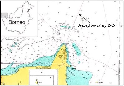
Figure 1 Gosong Niger
Another issue was then discovered that Malaysian Navy usually conducts patrol around Gosong Niger and does not allow Indonesian fishermen fishing in the area. Some sources said that the traditional fishermen generally do not know that the area is under Indonesian sovereignty as they could see Malaysian ship parking in the area almost everyday. Consequently, the Indonesian fishermen have no access to the natural resources around Gosong Niger.
With respect to the existing seabed boundary between Indonesia and Malaysia 1969, Gosong Niger is part of the seabed that is divided by the boundary line where two third of the seabed fall within the Indonesian side. With regard to this, the ownership of the sandbar is considerably clear. As there is a precise line, it should have been clear who own which seabed.
However, it has to be remembered that no territorial sea boundary has been established between Indonesia and Malaysia in that area (north of Tanjung Datu). In other words the two states have agreed a seabed boundary but have not yet agreed a boundary for the water column. This means that the arrangement for sovereignty over the territorial sea in the area is not yet clear. Consequently, no judgment can be made stating that Indonesian or Malaysian ship has done territorial trespassing. However, by de facto, the existing seabed boundary is, unfortunately, recognised as the territorial sea boundary as well. This might be the reason why Indonesia or Malaysia suspects that the activities within the territorial water were boundary infringements.
As two adjacent states in Borneo Island, Indonesia and Malaysia have overlapping claim with regards to territorial sea in the area of Gosong Niger. The absence of territorial sea boundary between Indonesia and Malaysia, consequently, leaves an uncertainty regarding the sovereignty over the territorial sea (water column). If Malaysians or Indonesians go beyond the boundary line, but still in the water column without touching the seabed, they do not infringe any agreement/law. The prosecution can only be made when Indonesians or Malaysians cross the seabed boundary line and conduct activities involving seabed of Gosong Niger.
Media says that Malaysia has established a permanent tourism service around the area and provide facilities for diving, swimming, and other aqua-tourism activities around Gosong Niger. If it is true, it might worth confirming that it is not an acceptable practice as the boundary between Indonesia and Malaysia has not been agreed. If the activities involve seabed exploration or exploitation, these can be considered as infringement.
Some opinions in Indonesia said that this is similar to the case of Sipadan and Ligitan, where Malaysia will finally be granted the sovereignty over Gosong Niger because it has been demonstrating effective occupation over the sandbar. It is actually not the case. There is a permanent and agreed boundary line between Indonesia and Malaysia in Gosong Niger, but not in Celebes Sea where Pulau Sipadan and Ligitan lie. The absence of permanent boundary line in Celebes Sea, ant the lack of legal official claims were the reason why the sovereignty over the two islands were disputed. In that case, the effective occupation (Effectivités) was a relevant consideration to decide the sovereignty over Pulau Sipadan and Ligitan. In contrast, the “ownership” of Gosong Niger has been made clear by the existence of a seabed boundary agreed in 1969. The infringement conducted by either Malaysia or Indonesia has nothing to do with its sovereignty.
This case is by no mean similar with Ambalat dispute. The Ambalat dispute, being in Celebes Sea, was due to the absence of permanent seabed boundary. In contrary, the seabed boundary in Gosong Niger has been clear so there is no need to establish a new seabed boundary unlike what is required with regard to Ambalat.
It seems that international boundary disputes have been one of Indonesia’s major problems lately. Many cases regarding international boundary, sovereignty and sovereign rights have caught everybody’s attention, including Ambalat case, island ownerships/disputes, Gosong Niger, border crime, ship piracy, etc. Many suggestions have been addressed to government and corresponding bodies but it seems that the reaction has been far for acceptable. Cases keep arising. It is understandable that the government is currently struggling with other bigger and more strategic issues such as corruption and natural hazards but it does not mean that the issue regarding international boundary and sovereignty/sovereign rights can be put in the last line and treated as the least priority.
Friday, February 03, 2006
My Thesis
It has been a while since my last posting.
I am reasonably busy lately with my thesis. Yes, the submission day is coming closer. I have to leave UNSW in less then two months. A flight ticket has even been booked for 28 March 2006. It is quite nervous to know that I will finally finish my thesis and leave for Indonesia.
Roughly, all chapter drafts have been written. Eight chapters were agreed to be compiled for my Master Thesis and most of them are currently corrected by Clive. Three chapters have been returned to me, even thouh none of them I have touched for revision. I am currently concentrating on checking the grammar of the last three chapters (6,7,8) before giving them to Clive for comments.
Honestly, I find it is hard to write in English. It is even worse because it is a scientific writing with all the rules of dos and don'ts. Referencing is the most important think, I believe. This is to avoid plagiarism, the one we all hate!
Btw, when started writing my thesis, I could not imagine how to write such a thick thesis with more than one hundred pages in it. Believe it or not, when you keep writing you won't realise that you have writen beyond the minimum pages you have to write. I have, so far, writen more than 135 pages, with more than 30 thousands words in it. What did I talk about in the thesis so I have written that much? Yes, that is the question I am always asking myself.
Anyway, no matter what happen, I have to finish my thesis on time. I hate having my scholarship extended! I will try hard and push myself till the limit so I don't need to extend my stay in Australia. Two years are more that enough. Not because I don't like Australia, I love being here in fact, but because I want to move on. There are still too many things to do. Indonesia is waiting for me, of that I am sure!
Monday, December 19, 2005
Tension builds over Ashmore Reef: Is it Indonesia's or Australia's?

I Made Andi Arsana
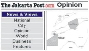 Ashmore reef (a.k.a. Pulau Pasir) is currently being disputed by Indonesia and Australia.
If we talk about an island/reef/islet, we are talking about sovereignty. In dealing with sovereignty we do not consider distance.
If we talk about a state authority in the sea territory, we are dealing with sovereign rights, not sovereignty. Distance becomes the key issue as it depends on the distance measured from the baseline, commonly the coastline depicting the low water line. With regards to this, it is true that we need to consider maritime zones and boundary issues. Read more...
Friday, December 02, 2005
Ashmore Reef: Indonesia’s or Australia’s?
I Made Andi Arsana
In Indonesia, Ashmore reef (a.k.a. Pulau Pasir) is recently popular. The hot issue is that the reef has been disputed by Indonesia and Australia. Indonesian Navy’s Chief of Staff stated that Ashmore reef definitely is under the Australian sovereignty (Republika Online, 24 November 2005). This might be quite surprising for some Indonesians believing that Ashmore reef is Indonesia’s.
It is worth mentioning that Indonesian society should have learned much from recent cases regarding boundary and sovereignty. Reading news in the papers and electronic media, it is understandable Indonesians can be easily emotional and sometimes irrational. Legal, technical and scientific aspects are often beyond news’ concerns. Is it because Indonesians love sensation more than information?
Sovereignty vs. Sovereign Rights
If we talk about an island/reef/islet, we are talking about sovereignty. Dealing with sovereignty means we do not consider distance. The statement of Mr. Tanoni regarding the status of Ashmore Reef conflicted with Indonesian Exclusive Economic Zone (EEZ) is indeed not quite right. (Republika Online, 23 March 2003) Just because a reef lies within Indonesian EEZ, it does not necessarily mean that it belongs to Indonesia.
If we talk about State authority in the sea territory, we are dealing with sovereign rights, not sovereignty. Distance becomes the key issue as it depends on distance measured from baseline, commonly coast line depicting the low water line. With regards to this, it is true that we need to consider maritime zone and boundary issues governed by the United Nations Convention on the Law of the Sea (UNCLOS).
Ashmore: Whose Reef Is It Anyway?
The sovereignty over a reef cannot be carelessly decided. It is not depending on its distance to a State’s main land. It deals with legal aspect.
A website in the Netherlands reveals that Ashmore reef was annexed by Britain in 1878. Together with Cartier Island, Ashmore was transferred to Australia on 23 July 1931 and is then part of the Northern Territory of Australia (1938–1978). In 1978 Australia established Ashmore and Cartier Islands Territory and finally Australian government formed Ashmore Reef National Natural Reserves on 16 Augustus 1983. Of course we do not nave to trust the internet site. More intensive studies need to carry on.
CIA website, one of the resources people may trust, reveals similar facts. CIA’s World Fact Book confirms that Ashmore reef is under the Australian sovereignty. Another support also comes from GEsource website in the UK.
By plotting the coordinates of Ashmore Reef (12° 13.98' S, 123° 4.98' E) in the Indonesia-Australia EEZ boundary map, it is clear that Ashmore Reef lies within the Australian EEZ. This, implicitly, implies that Indonesia has acknowledged the Australian sovereignty over the reef.
From a historic point of view, it is true that the ancestors of Timor people came to Ashmore Reef since 1630s. However, Rais (2005) asserts that the Netherlands never secured the reef in its colonial territory and the government administering the reef was Britain. Indonesia could not claim Ashmore Reef just because their ancestors came there, did economic activities and died in the reef provided that the government administering the reef was not its predecessor (the Netherlands). In their article in Kompas (11 April 2005) Prof. Jacub Rais and J.P. Tamtomo assert that the Indonesian Proclamation of Independence secured all the former areas of the Netherlands (not others) as people in those areas had the same experience during colonialism.
It is indeed ironic that Indonesians (Timorese and others) who have been visiting and carrying activities in Ashmore Reef for hundreds of years (Kompas, 28 May 2005) are not entitled to own the Reef, while Britain (Australia), who “discovered” Ashmore in the nineteenth century, secures stronger rights. It is worth noting that modern law emphasizes legal claim rather than visits and activities. If it is true that Britain legally claimed and administered Ashmore Reef and the Netherlands did not protest, its sovereignty will obviously be Australia’s.
By contrast, Ferdi Tanoni states that there are strong evidences that Ashmore Reef were part of the Netherlands during the colonial era. He asserts that the implementation a regulation regarding sea cucumber and other marine biota collection around Ashmore Reef is a convincing evidence for its claim over the Reef. Unfortunately he did not specifically mention the document he referred. However, it this is true, it could possibly invalidate British Claim over the Reef in the eighteenth century.
Agreements between Indonesia and Australia
In 1971/1972, Indonesia and Australia agreed Continental Shelf (CS) boundary (seabed) where the boundary line located far North, close to the island of Timor (Indonesia). Some experts opined that it is not an equitable boundary. Apart from the unfairness and the failure of Indonesian diplomacy in the past, it is worth understanding that the agreement was signed before the UNCLOS came into force. Therefore, the quality of the agreement could not be judged using UNCLOS.
The Australian argument emphasized the principle of natural prolongation. The data available at that time suggested that the natural break of the Australian continent and Indonesian continent exists close to Timor Island, so that the CS boundary lies far from the median line favoring Australia. This practice was supported by legal development at that time. The ICJ’s judgment on 20 February 1969 regarding The North Sea CS case between Germany and Denmark, for instance, significantly considered geomorphology of the seabed or the principle of natural prolongation. In other words, Australian argument was supported by jurisprudence. However, the development post-UNCLOS tends to consider seabed geomorphology less. In the case of Libya and Malta (1985), for example, the ICJ decided that within 200 nautical miles, seabed geomorphology is irrelevant and the court’s judgment was based on distance principle.
It might be true that the CS boundary between Indonesia and Australia is inequitable. However, it is worth noting that the decision was with regards to the positive law applicable at that time. If required, Indonesia may renegotiate the boundary with Australia, provided that Australia agrees to do so. However, it is most likely that Australia does not want renegotiation.
Another agreement requiring attention is the 1997 EEZ boundary. Unlike the CS boundary, this is much more equitable as the border lies in the median line between the two States. Unfortunately, Indonesia has not yet ratified the agreement in its internal law.
Regarding Ashmore Reef, there is an MoU in 1974/75 allowing Indonesian traditional fishermen fishing around Ashmore Reef. Surprisingly (to Indonesia) Australia, in 2002/2003, restricted Indonesian fishermen from fishing in the area due to environmental conservation. This must attract the attention of Indonesian government and it should responsively clarify this as this endangers Indonesian fishermen’s life.
The Last Words
Undoubtedly, it is Indonesians obligation to keep the archipelago exists and united. However, clear understanding regarding legal, technical and scientific aspects are essential. Everybody should carefully analyze and be more critical toward every single issue regarding border conflict. A wrong decision may lead Indonesia to a huge material loss as well as reputation degradation as it might be considered as an emotional and irrational society.
The available legal evidences, so far, tend to suggest that Ashmore Reef is under the Australian sovereignty. However opinions and arguements sugesting that it is part of Indonesian Territory is worth to seriously consider. Let’s do our parts and let the governments do their best to achieve the most equitable solution for both sides.
Wednesday, November 23, 2005
Expert Advice
Intensive studies and good efort to build networks have slowly borne fruit. Started from teaching activities, now some even come to ask for expert advice. I still could not believe somebody asked me to provide my expert opinion regarding maritime boundaries :(
An Indonesian delegate came to Canberra last week searchig for data and advice regarding maritime boundary delimitation among Indonesia, Timor Leste and Australia. Through Pak Hanung of DKP, whom I taught during a short course in CMP, Wollongong University, I was invited to come and join the discussion. It was such a good opportunity as I can directly contribute to the real problem Indonesia is currently facing.
I met Collonel Sugito of Dishidros and alao Pak Kris, the acting Ambasssador of Indonesia for Australia. The discussion was good and also excellent contacts were made. I, in a very short period, wrote a short popular-scientific paper describing the options of maritime boundary delimitation between Indonesia and Timor Leste. Hope the opinion will help, even though just a bit.
Wednesday, November 16, 2005
Lecture in CMP, Wollongong University
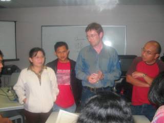 It is the third or fourth lecture I gave in the Center for Maritime Policy in the University of Wollongong. The lecture is a very good experience for such a young academic like me. Not only it gives me money :) but also provides me with opportunity to build a strong network for my carrier in the future. I met some top guys from Indonesian goverment institutions and have made very good contacts. See picture
Monday, November 14, 2005
Book Chapter
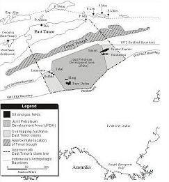 Still remember my presentation in the ICOC last September in Adelaide? Yes, the one about Indonesia-Timor Leste maritime boundary.
My presentation was apparently quite interesting, at least to Dr. Kingsbury of Deakin University (yes, right! I mentioned his name in my report too). He offered me to include my paper in his edited book. This is, of course, a very good offer. Clive and I (the paper is a joint-paper) then worked hard to edit the paper and broadened the scope not just to cover Indoensia and Timor Leste but also Timor Leste-Australia maritime Boundaries.
A distant collaboration was then taken place as Clive is in Wollongong and I am in Sydney. Guess what, we kept emailing every five minutes to discuss this and that. It was a very good virtual collaboration and we finally came up with a final draft with four figures. I created the figures myself using Corel Draw and those are driven from the analysis using CARIS LOTS. The reason why they have to be re-drawn because the book cannot contain colored image and also because the images coming directly from CARIS are not printing-ready.
Well, the chapter will be my first English publication in an edited book. What a good experience for a young academic like me!
Tuesday, November 08, 2005
Best of the Best

FYI, I presented my research about maritime boundary delimitation between Indonesia and Timor Leste, which is actually part of my master thesis. The judges, consisting of UNSW, Leica Geosystems, and NSW Dept. of Lands [?], for the reasons that I don't really know, placed me as the best presenter in the session I was presenting in as well as the best presenter in all categories. Please have a look at my presentation, if you like.
Monday, October 31, 2005
Berhala in the JP
On Sept. 26, 2005 Antara official news agency carried a report on the concerns of a North Sumatra's provincial legislator regarding a website promoting Pulau Berhala as one of Malaysia's tourist destinations. When reading this, Sipadan and Ligitan come to mind. The two islands were secured by Malaysia when the International Court of Justice (ICJ) ruled that sovereignty over them rested with Malaysia in 2002.
In Indonesian minds this scenario raises disturbing questions: Is Malaysia now pushing its luck and seeking to secure small, isolated islands in boundary areas one by one? Is Pulau Berhala vulnerable and could there be a repeat of the Sipadan and Ligitan case? Read more...
Saturday, October 01, 2005
Berhala: Another Sipadan and Ligitan?
The news in ANTARA on 26 September 2005 was about the concerns of North Sumatra’s FPPP provincial legislative councils regarding a website promoting Pulau Berhala as one of Malaysia’s tourist destinations. This was addressed by Fadly Nurzal, a representative of FPPP. When reading this, Sipadan and Ligitan come in mind. The two islands have been secured by Malaysia as the International Court of Justice (ICJ) decided to award their sovereignty to Malaysia in 2002. Does Malaysia push its luck to secure one by one small islands in the boundary area? Will Pulau Berhala repeat the history of Sipadan and Ligitan? Let’s see what happens!
As far as I am concerned, there are at least three different islands called Berhala. The first island is the one referred by Nurzal in Malacca Strait, around 48 Nautical Miles from Port Belawan. The second Berhala is in Berhala Strait close to Riau Archipelago that has been a source of conflict between Jambi and Riau for such a long time. The last one is close to Sandakan, North Borneo, which has been a tourist destination and is fabulous for diving. The second Berhala is clearly Indonesia’s, while the third one is definitely Malaysia’s.
Unfortunately ANTARA did not clearly mention the website referred by Nurzal. Therefore it is not a hundred percent clear which Berhala Malaysia promotes as its tourist destination. If the island it promotes is the one close to Sandakan, Nurzal must have been careless in expressing opinion. Hopefully that is not the case.
If Pulau Berhala in question is the one in Malacca Strait, then it will be a different story. Indonesian government has to pay extra attention as this may lead to the loss of an island. Pulau Berhala, as stated by the Hidro-Oceanographic Office of the Indonesian Navy (Dishidros), is one of the 12 small islands which are critical due to their position in the international boundary area.
The other eleven islands are Pulau Rondo (Indonesia-India); Pulau Nipa (Indonesia-Singapore); Pulau Sekatuang (Indonesia-Vietnam); Pulau Marore, Pulau Mianggas and Pulau Marampit (Indonesia-Philippine); Pulau Batek (Indonesia-Timor Leste); Pulau Dana (Indonesia-Australia); Pulau Fani, Pulau Fanildo, and Pulau Brass (Indonesia-Palau).
Let’s look closely to Pulau Berhala in Malacca Strait and review the maritime boundary agreement between Indonesia and Malaysia.
In 1969, Indonesia and Malaysia entered into an Agreement dividing the continental shelf between the two countries in Malacca Strait and ratifications were exchanged on 7 November 1969. Ten points are agreed as the turning points of the boundary line.
Some opined that the agreement is not an equitable solution as Malaysia applied straight baseline connecting its outermost islands while it is not an archipelagic state. This causes the boundary line lies closer to the Indonesian side and is considered as inequitable. However, Indonesia and Malaysia have signed the agreement and it has been binding for both countries for such a long time. Now, it is not important to discuss how the boundary has been achieved but to obey the agreement, unless the boundary needs renegotiation.
Unlike the uncertainty of Sipadan and Ligitan as there has been no definite maritime boundary in Celebes Sea, the continental shelf boundary in Malacca strait should have made the status of Pulau Berhala clear. Based on the 1969 agreement, the International Boundary Study of the Department of State, US analyzed the boundary and found that Pulau Berhala belonged to Indonesia. This was clear in the analysis of the study, especially in the table of characteristics of the border points (The Geographer, 1970).
Experiences tell that the arguments of chain of title based on the history are often not strong enough to prove the ownership an island. Indonesia or Malaysia could refer the history to prove that an island belongs to it but often it is hard to agree. This is because there is no dateline since when such history should be considered. This was also the case when the ICJ decided the case of Sipadan and Ligitan by considering the principle of effectivités. Historic arguments proposed by Indonesia and Malaysia could not convince the court and were rejected. The principle of effectivités looks more to the effective legal action done by countries in question to the islands. The court found that Malaysia, proceeded by the Great Britain, have done much more to maintain Sipadan and Ligitan Islands. Therefore the "sovereignty over Pulau Ligitan and Pulau Sipadan belongs to Malaysia”
In the case of Pulau Berhala, we will also assess the principle of effectivités and see how it goes.
In 1984, Indonesian Government built a lighthouse in the Island and since has been maintaining the lighthouse by continually assigning lighthouse attendants. This can be considered as a legal action proving that Indonesia has done the appropriate things as the owner of Pulau Berhala. Maintenance of the lighthouse requires Indonesian Government to take care the environment; otherwise the lighthouse will not be able to function properly. This also proves the role of the Indonesian Government in Pulau Berhala fulfilling the principle of effectivités. Therefore, based on the principle of effectivités, Indonesia deserves to be the legal owner of Pulau Berhala.
In a technical perspective, a spatial assessment needs to be done by plotting the coordinate of Pulau Berhala together with the border lines in an appropriate-scaled nautical chart. By plotting the location of Pulau Berhala and the boundary line in a chart, it will be clear whether Pulau Berhala lies in the side of Indonesia or Malaysia.
We will see how Indonesia and Malaysia deal with this kind of problem. It is very important for all citizens to clearly understand the problem and support the governments to do their best. Instead of being over-reactive, let’s be calm and patient.
Tuesday, September 27, 2005
Indonesia Council Open Conference, 2005
[Adelaide, 26-27 September 2005] Being the only surveyor presenting in a social science conference is an interesting experience. The Indonesia Council Open Conference, 2005 is an annual conference hosted by Flinders University in Adelaide with the support of The Flinders Asia Centre and the Inside Indonesia magazine, where my presentation is the only technical paper among many social papers presented. Being a social science conference, almost all presentations are about to social issue, especially, of the Indonesian society.
The topics presented were vast and diverse from the literacy issues to Indonesia's future. Most of the topics might not be interested for a surveyor/geodesist. Therefore it is not important to discuss each topic here.
I presented my paper, "Maritime Boundary Delimitation between Indonesia and Timor Leste: A Technical Perspective", on 26 September 2005 in the session of Boundaries, migration and foreign policy. Being the only technical paper, the presentation attracted intention form most audiences and also drew some interesting questions and comments. Different from the other presentation which were filled with words, my presentation was dominated with graphics and pictures [maps]. All the technical aspects I introduced coupled with legal consideration [law of the sea] in defining maritime boundaries were quite interesting to the audiences. This, I belive, was a good moment to remind them surveryor's contribution to such an international matter (i.e maritime boundaries).
A senior lecturer from Deakin University, Dr. Damien Kingsbury gave very good comments and suggestions regarding my research, as he significantly knew East Timorese views about the maritime boundaries in question. He also promised to introduce me to an East Timorese geographer who is currently dealing with the Boundary issue. This will be a very good information resource.
To sum up, apart from the fact that the conference is more about social science, it was still a very good event to share ideas, especially to enrich the resource of my research as a multi-disciplinary one.
For more information please visit the website. Please also contact me for a proceeding containing colection of abstracts.
Tuesday, September 06, 2005
Giving a Lecture in Wollongong University
Surprise!!!

The students are all Indonesians from [nearly] all around Indonesia. Some of them are from Department of Fisheries and Marine Affairs, while some others are from Regional Governments.
They looked very entusiastic listening to my lecture about Indonesia's Internal Boundary Issues. It was understanable as it was the only lecture in Bahasa Indonesia. A student, jokingly, said that my lecture is the only lecture he can understand, making his colleagues laugh.
It was a very good experience! More...
Sunday, September 04, 2005
Indonesia Council Open Conference 2005, Monday 26-27 September 2005, Adelaide

Chris, my supervisor, generously provides economical return flight ticket for the conference. I Thank him very much for his generousity.
The news/add for the conference has been posted in the South East Asia times website at the left sidebar.
Sunday, August 28, 2005
Map Asia 2005, Jakarta 22-25 August 2005
[an epilogue]
 Map Asia 2005 is the 4th annual conference organized by GIS Development PTE. Ltd. - Singapore in collaboration with Indonesia’s Bakosurtanal, Asosiasi Perusahaan Survey dan Pemetaan (APSPI ) – INDONESIA, Center for Science, Development and Media Studies (CSDMS) - India,and the Asian Institute of Technology - Thailand. The conference was undertaken in Mulia Hotel, Jakarta Indonesia on 22-25 August 2005. Bellow are some important notes about the conference.
Registration and Opening Ceremony
The registration started at 10 am and ended at 4 pm when the opening ceremony began. The conference was officially opened by The Indonesian Minister of Research and Technology, DR. Kusmayanto Kadiman, who is an alumnus of the Australian National University. Other speeches were also delivered by The Head of Indonesia’s Bakosurtanal (MR. Matindas), the president of Map Asia 2005 (Prof. Narayanan), and local organizing committee (Mr. Purnawan).
Hitting the “Gong” officially inaugurated the conference and all its programs including exhibitions, technology shows, and workshops. The ceremony ended with an inaugural dinner in the Grand Ball Room of Mulia Hotel.
Plenary and Keynote Sessions
The first day [23 August 2005] started with plenary session I: empowering People through Geospatial Information with three speakers. This was followed by keynote session I : Web GIS with also three speakers. The second day [24 August 2005] has one plenary session and one keynote session with total of 5 speakers. The plenary session was on Regional Cooperation while the keynote session is about Large Scale Mapping. In keynote session, speakers excessively discuss the advance in large scale mapping and the availability of large scale data in the internet. Google Earth was one of the phenomena that discussed a lot.
Seminar Sessions
There were three seminar sessions in the conference. I presented my paper in one of the seminar sessions: Marine and Coastal GIS which was chaired by Drs. Michiel Damen from ITC, the Netherlands. My paper is “Ambalat: A Spatial and Technical Perspective”, penned with Clive Schofield of The University of Wollongong. Other seminar sessions are Space Program and RS, and Disaster Management distributed in some parallel sessions. That is why, it was impossible to attend all presentations as some are delivered at exactly the same time.
Technical Sessions
This consists of 16 sessions: Geological Applications; Water Resources; Land Information System; Open Geospatial Consortium workshop on interoperability; Disaster Management; Traffic and Transportation; Precision Farming and Agriculture; Environment and Forestry; Urban and Town Planning; Digital Image Processing; Web GIS/Internet GIS; Photogrammetry and 3D Visualization; Database Design and Ontologies; Land Cover, Use and Change; Emerging Applications; Natural Resource Exploration and Planning. Similar to seminar session, this session was also distributed into some parallel session in different venues, so visitors had to decide which presentation to attend.
Networking
The Conference, to me, was a very good event where we could start building international networking among experts, industries and users of geospatial technology. Some opportunities were available such as software share, training, data exchange, collaborative research, etc. Some industries even freely distributed data, software, magazines and books to exhibition visitors.
More Information
For more information, please visit www.mapasia.org. Proceeeding CD and abstracts collection are available. Please contact me for a copy
Subscribe to:
Posts (Atom)

