

in collaboration with
National Coordinating Agency for Surveys and Mapping
Proudly presents:
INTERNATIONAL WORKSHOP ON LEGAL AND TECHNICAL ASPECTS OF MARITIME BOUNDARY DELIMITATION
Yogyakarta, 6-7 May 2005
I. Background
As an archipelagic country, Indonesia has some potential maritime boundary with some adjacent and opposite neighbouring coastal States. This is due to potential overlapping claims of maritime zone between Indonesia and its neighboring States. With regards to potential maritime boundaries, ten States are considered: Republic Democratic of Timor Leste (RDTL), Malaysia, Papua New Guinea, Singapore, Australia, Palau, Philippines, Thailand, India and Vietnam.
Most of the boundaries have not been fully established. The case of Ambalat is one of the consequences of the pending agreement of maritime boundary between Indonesia and Malaysia in Celebes Sea. The ownership of Batek Island is also an important issue that Indonesia and RDTL need to agree upon, as the steps to establish maritime boundaries between the two countries. These situations potentially raise conflict between the States in question and at the end cause inconvenience to the inhabitants in rolling their economic activities. On the other hand, Indonesian societies, in general, are quite easy to be negatively provoked with regards to boundary issue. In most cases, they do not really understand the real problem, especially in terms of legal and scientific substance. In addition, unbalanced reporting by newspaper and electronic media sometimes also worsens the situation.
Indonesia ratified the United Nation Convention on the Law of the Sea III (1982) in 1985. However, it faced several technical and non-technical obstacles in implementing the Convention to generate acceptable maritime boundaries. The problems include funding matter, partial claim by neighbouring states, and the availability of legal administrative resources/documents for negotiations.
This workshop is proposed based on two key reasons: the complexity of the maritime boundary definition that needs proper training, and the lack of information distribution among societies, especially with regards to legal, technical and historical aspects. This is expected to facilitate the share of knowledge among experts, technical contributors and even ordinary people about maritime boundary delimitation to obtain an equitable solution.
II. Aims and objectives
- To socialize legal and technical aspects of maritime boundary delimitations.
- To socialize approaches employed in solving cases related to maritime boundary dispute.
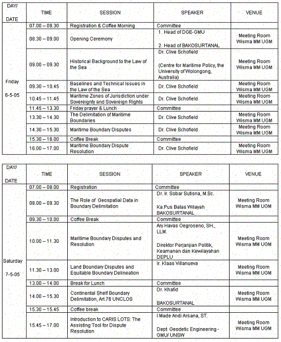
III. Schedule
IV. Fees and Registration:
- Indonesian participants
- Full booth ( workshop kit dan penginapan) Rp 750.000,-
- Standar (workshop kit tanpa penginapan) Rp. 500.000,-
- Overseas Participants
- $US 250.00 (with workshop kit only)
For registration, please contact:
Committee secretariat for International Workshop of Department of Geodetic Engineering, Gadjah Mada University
Jl. Grafika No.2 Yogyakarta
P: +62 274 520226 atau +62 274 902121
F: +62 274 520226
E: geodesy_ugm@yahoo.com, dwil_yk@yahoo.com
Fees can be transfered to Bank Account:
Bank Mandiri MM-UGM Branch
Account number: 137.0002172.514
Account holder: Ketua Jurusan Teknik Geodesi FT-UGM
Contact persons:
Dwi Lestari +62 8132 8175507
Abdul Basith +62 815 7941196
Tertarik mengikuti workshop International ini?
Silahkan lihat di sini
Sampai jumpa di Jogja!

No comments:
Post a Comment