
Dear Mr. I Made Andi Arsana
We take the pleasure to inform you that your paper “AMBALAT: A Spatial And Technical Perspective” has been accepted by the Map Asia 2005 review committee to be presented Orally during the Technical Session on " Coastal Zone Management " during Map Asia 2005, to be held during 22 - 25 August 2005, in Jakarta, Indonesia. The Technical Session is subject to change depending on the final Programme schedule
We would also appreciate if you could arrange to send the Full manuscripts of your presentation to be made at Map Asia 2005 before 15th July, 2005 to enable us to incorporate it in the conference proceedings to be released on the occasion of the conference.
For further correspondence kindly refer to your Paper as: PN 043
It may kindly be noted that on acceptance of the full paper, the author needs to accept the terms and conditions laid down in the Copyright & Author's agreement.This agreement shall be mailed along with the acceptance notification of the full paper.
Looking forward to your participation in Map Asia 2005.
Kind Regards
Shivani Lal (Ms.)
 Karya I Made Andi Arsana, ST., ME
Batas Maritim Antarnegara - Sebuah Tinjauan Teknis dan Yuridis
(Gadjah Mada University Press, 2007) more...
Karya I Made Andi Arsana, ST., ME
Batas Maritim Antarnegara - Sebuah Tinjauan Teknis dan Yuridis
(Gadjah Mada University Press, 2007) more...Tuesday, May 31, 2005
Acceptance Letter for Paper Presentation at Map Asia 2005
Friday, May 27, 2005
Problem with Geo-referencing
It has been so long since my last posting about my research (read: my thesis). I have been spending so much time to play with other issues including Ambalat. However, it is an important moment for my academic career path!
So, it is the time to get back to Timor Leste issue.
Data
I have collected data from Bakosurtanal and Dishidros but unfortunately none of the data is in vector format. Bakosurtanal gave the nautical chart of Timor Island in Adobe Illustrator format that is convertable into TIFF. In my hand now are some files in TIFF depicting Timor Island in some different sheets.
Image Registration
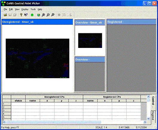
In order to be able to process the data using CARIS LOTS, it has to be geo-registered. This is a standard proces in dealing with image data that has not yet geo-referenced.
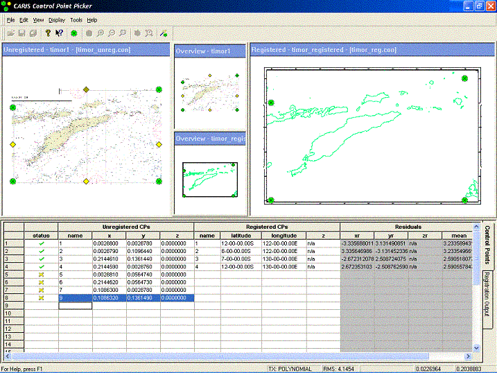
Good news, CARIS is equipped with that kind of function so, this can be ,theoritically, done easily. However the actual process has never been as simple as the plan. The TIFF image after being imported into CARIS did not appear clearly so it was really difficult (if not impossible) to process the registration. How could you pick the common control points if you can't even see the image clearly? The only thing shown was a black image illustrated bellow.
What to do next?
After googling for days and trying many possibilities, I finally came up with a solution. There was something to do with the compression. The image has to be compressed using LZW & Differencing. I did it using Microsoft Photo Editor. Thanks to Uncle Bill Gates! :) The image could then be easily imported into CARIS to be registered. The next process are to define the basepoints and simulate the boundary line possibilities.
Have you had a similar experince with registration? Try this! More...
Friday, May 20, 2005
Abstract for Map Asia 2005
I Made Andi ARSANA1
School of Surveying and Spatial Information Systems
The University of New South Wales
madeandi@student.unsw.edu.au
Dr Clive SCHOFIELD2
Center for Maritime Policy
University of Wollongong
clives@uow.edu.au
Abstract
During March 2005, the bilateral relationship between Indonesia and Malaysia deteriorated. This was primarily related to competing claims to the “Ambalat offshore area” located in the east of Borneo Island in the Celebes (Sulawesi) Sea.
The dispute resulted in strong reactive responses in both countries, but particularly in Indonesia. This is understandable as many Indonesians generally believe that the dispute deals with sovereignty and are concerned over further territorial losses in the aftermath of Malaysia’s victory in the case concerning Sipadan and Ligitan islands with Indonesia in 2002. Regardless of reasons the International Court of Justice (ICJ) provided, most Indonesians were simply disappointed. Since issues of international boundaries, territory, sovereignty and sovereign rights are highly sensitive, it is important for all concerned from both countries have to really understand the scientific, technical, and legal dimensions of any dispute.
This paper discusses the case of Ambalat in a spatial and technical perspective. Simulations have been done exercising the maritime claims of Indonesia and Malaysia in Celebes Sea using global chart data. GIS software, CARIS LOTS™, was utilized as an assisting tool to technically generate baselines, maritime zone limits and maritime boundary lines for the two countries. The simulations spatially show the change of Indonesia’s baseline due to the ‘loss’ of Sipadan and Ligitan islands that consequently change the boundary. Conclusions are then drawn as to the relative merits of each State’s claims to Ambalat and the prospects for resolution of the dispute.
Keywords: sovereignty, baselines, maritime zones, maritime boundaries, GIS, dispute
Footnotes
1A Lecturer at Department of Geodetic Engineering, UGM, currently studying technical aspect of International Maritime Boundaries at the University of New South Wales, Sydney, Australia
2Senior Lecturer, Centre for Maritime Policy, University of Wollongong, Australia More...
Sunday, May 15, 2005
Once again: Ambalat
[Interesting points from Prof Rais]
Prof. Jacub Rais, the father of geodesy in Indonesia, also expressed his opinion about Ambalat. As an expert in maritime issues and toponim he has some interesting points about Ambalat. His complete article can be found in Kompas, 11 April 2005.
Some points are important to note:
- Ambalat is the case dealing with sovereign rights, not sovereignty. This is important to understand where we can fully apply full sovereignty and where we can only exercise our rights to explore and exploit natural resource.
- Kalimantan is officially unknown. Borneo id its formal geographic name.
- Sipadan and Ligitan have never been listed in Djuanda Declaration and neither in Dutch Archive. It is not entirely true saying that we’ve lost the two islands. How could we lose something never belong to us?
- Government has not intensively socialized important issues such as UNCLOS, maritime zones, etc.
- It is very important to start thinking about marine cadastre to administer our coastal zones, maritime and islets including associated rights, boundary, and obligation.
- The administration includes toponim, field survey, mapping the boundaries and publish it in an official publication.
- It is essential for government official and people representatives to understand UNCLOS III and how to implement the rule for Indonesia’s needs.
- We are not to worry about losing outermost islets but develop the area to reflect government’s responsibility to the inhibitants.
- It is not the international boundaries that are important but inter-province boundaries, which has not yet rule and specific guidance. This is a potential conflict in the future.
- An ethnic-based division of Indonesian region is not a very good idea since it can retain ethnic sentiment. Prof. Rais suggested a bio-physic consideration such as water shed feature to delineate boundaries between provinces and regencies.
- Make marine cadastre not war!
Saturday, May 14, 2005
Seminar and Workshop in Indonesia: a Report to Chris Rizos
Dear Chris,
I am happy, finally arrive back in Sydney. All programs in Indonesia were done well. Here is list of activities and the results
1) 2 May 2005: Arrived in Jogja at 7.15 pm local time
2) 3 May 2005: Seminar "The fragility of Indonesia's Archipelagic Boundaries, Reflection of Indonesian Society to Ambalat"
Clive was one of the presenters, presenting "The Delimitation of Indonesia's Maritime Boundaries". Other Presenters are: Arif Havas Oegroseno (Indonesia's Department of Foreign Affairs), Kol. Laut Drs. Rusdi Ridwan, Dipl.Cart (Indonesian Navy's Hydro-Oceanographic Office), Dr Sobar Sutisna (Bakosurtanal), Hj. Endang Purwaningsih, SH, MH (Law Faculty, UGM), and Drs. Lambang Triyono, MA (enter for Security and Peace, UGM)
I was appointed to be the moderator for Clive and Sobar' session discussing International Boundaries.
Generally speaking, there were interesting sessions in the seminar with 250s audiences coming from universities, national and regional government, professionals and NGOs. Good and hot discussion were generally about Ambalat case. It was surprising that many people thought that Ambalat is an island. The seminar should have been a good time to give better understanding for the laymen.
3) 4 May 2005: Discussion with the Department of Geodetic Engineering (DGE), UGM. I was appointed to be the moderator for three sessions. 1) Djawahir of DGE presented the activities related to land boundary definition between Indonesia and East Timor. Clive at the discussion gave comments and suggestions on some difficulties they faced. 2) Discussion on DGE's new curriculum. DGE plans to create a new lecture in their 2006 curriculum: Boundary Definition. Clive was expected to contribute ideas how the lecture should be structured. Based of discussion, the new lecture should be a complementary lecture to the existing one DGE currently teaching, Geodetic Aspect of The Law of the Sea. 3) Discussion on the possibility to conduct cooperation between DGE, CMP and UNSW, if possible. The issues discussed are the possibility to conduct faculty exchange, student exchange, postgraduate studies, and joint-research. It was concluded that possibilities are open as long as we can secure the funding. Clive suggested to see the possibility to utilize funding from ARC, ADB and World Bank. Other form of cooperation is short course and training as a collaboration among DGE, Australian Institution (CMP, for example) and Indonesian Government ( e.g. Bakosurtanal)
4) 5 May 2005: City tour (Borobudur and Prambanan temple, Sultan Palace, Batik Shopping, Jogja outback visit, Mount Merapi overview)
5) 6 May 2005: Workshop day 1: Legal and Technical Aspects of Maritime Boundary Delimitation. The workshop is officially opened by Matindas, the head of Bakosurtanal. Clive was the only speaker on the day, presenting materials in six sessions. There are about 25 Audiences from universities, Bakosurtanal, Department of Fisheries and Maritime Affairs, NGO, regional Government, etc. Hasan Z. Abidin, Klaas Villanueva, Dr. Khafid, Sobar Sutisna and some other Indonesian Experts also attended the workshop.
6) 7 May 2005: Workshop day 2: Legal and Technical Aspects of Maritime Boundary Delimitation. There were five presenters in five different sessions. In the first session, Sobar Sutisna presented "The role of geospatial data in Boundary delimitation". This is followed by Arif Havas Oegroseno (Dept. of Foreign Affairs) presenting "Maritime Boundary Disputes and Resolution". The third presentation by Klass Villanueva was about "Land Boundary Disputes and equitable maritime Boundary delineation". Material about Indonesia's potential extended continental shelf was presented in fourth session by Dr Khafid (Bakosurtanal). This was followed by the last session where I presented the Introduction of CARIS LOTS™ for Maritime Boundary Delimitation and Dispute Resolution.
Clive and I agree that the Seminar and workshop are good programs and it was a good time to meet Indonesian experts in boundaries. Other thing, Sumaryo, my dept head also suggested me to search for possibilities to continue my study into PhD level.
Thank you!
cheers
Andi
Friday, May 13, 2005
Letter of Acceptance for ICOC 2005

c/- Michele Ford
School of Political and International Studies
Flinders University
3 April 2005
Dear Andi
I am delighted to advise you formally that the abstract you submitted for the Indonesia Council Open Conference 2005 has been accepted.
ICOC 2005 will provide an excellent opportunity for you to spend time with other Indonesianists and to hear about new research. While you are at the ICOC, we would also like to invite you to attend the Flinders Asia Centre Annual Lecture, which is to be delivered on the evening of Monday 25 September by Sidney Jones.
We look forward to meeting you in Adelaide in September, and will contact you periodically before then with the conference program and other information about the conference.
Best wishes
Michele Ford
ICOC 2005 Conference Convenor
Abstract Submitted to ICOC 2005
BETWEEN INDONESIA AND TIMOR LESTE:
A TECHNICAL PERSPECTIVE
I Made Andi ARSANA, INDONESIA
The University of New South Wales
madeandi@student.unsw.edu.au
Geodetic Engineering, Gadjah Mada University
madeandi@ugm.ac.id
Clive SCHOFIELD, UK
Centre for Maritime Policy, University of Wollongong
clives@uow.edu.au
Abstract
The 1999 referendum liberated East Timor making it an independent country. As adjacent coastal States, Indonesia and Timor Leste are currently faced with the challenge of delimitating their maritime boundaries. According to Indonesia’s Department of Foreign Affairs, negotiations on this particular matter have yet to start.
This paper aims to provide a preliminary study on how the delimitation of the Indonesia – East Timor maritime boundary could be achieved, focusing on its technical aspects. A number of alternative potential boundary alignments will be examined and analysed in the context of the maritime boundary negotiations between the two States.
The United Nations Convention on the Law of the Sea, LOSC, will provide the main legal reference point, together with relevant state practice and jurisprudence. Technically, potential delimitation lines will be calculated in a geodetically robust manner with the assistance of a specialised Geographic Information Systems (GIS) application. This paper concentrates on specific contextual issues around the definition of the maritime boundaries and explains associated technical terms.
Keywords: maritime boundary delimitation, law of the sea, LOSC
Presenting Author’s Details:
Name : I Made Andi ARSANA
Position : Postgraduate Research Student
Institution/Organization : UNSW, Sydney
Address : 2/10 Houston Road, Kensington
City : Sydney
Postcode : 2033
Country : Australia
Tel : (02) 9662 6023
Fax : (02) 9313 7493
E-mail : madeandi@student.unsw.edu.au More...
National Seminar: The Fragility of Indonesia’s Archipelagic Boundaries, Reflection of our society for Ambalat
[a small note]
The seminar organized by Gadjah Mada University’s Geodetic Engineering Students Association and supported by Coordinating Agency for Surveys and Mapping (Bakosurtanal), was opened by Prof. Indarto, dean of Engineering Faculty, at 9.00 am. Some items are important to be noted as critical phenomena reflecting the way our society responds to such an international conflict.
Once again, Ambalat is not an island.
It is anticipated that some people are not aware that Ambalat is not an island. They think that Ambalat is an Indonesia’s island claimed by Malaysia. This is even worse because the opinion said not only by ordinary people but also by the dean when giving an opening speech. A speaker from Law faculty, unfortunately also said something similar. What a shame! This is a very serious mistake especially when addressed by an academia, the one people should trust. Believing Ambalat as an island gives a significantly different legal perspective to the case. In the principle of sovereignty, two terms are known: sovereignty and sovereign rights. The two terms are significantly different and need serious awareness before applying them to such an international case. Sovereignty is applicable to land territory (e.g. island), internal waters (or archipelagic waters) and territorial sea. If some people think that Ambalat is an island, they may also think that full sovereignty must be applied. This could be worse because they will opine that Ambalat is an island that belongs to Indonesia and is currently claimed by Malaysia. Understandable if ‘war’ and ‘Ganyang Malaysia’ are their answers.
Once again, Ambalat is not an island but seabed area which is predicted (according to available data) to conserve potential oil and gas deposits. This was asserted by Arif Havas Oegroseno, the director of Directorate of Treaties on Political Security and Territorial Affairs, Indonesia’s Department of Foreign Affairs. Simply speaking, talking about Ambalat is talking about seabed, not an island. According to its distance from Borneo, Ambalat lays in the Exclusive Economic Zone of Indonesia and Malaysia or even in the Continental Shelf because it relates to seabed area.
Malaysia is not entitled to claim Ambalat?
An Indonesian official stated that Malaysia is not an archipelagic state, thus it is not entitled to territorial sea claim. This is a ridiculously misleading statement.
According to the convention on the law of the sea, a coastal state was entitled to claim territorial sea, EEZ, and Continental Shelf as long as it meets required criteria (distance and geology). Undoubtedly, both Indonesia and Malaysia, which has ratified UNCLOS III, are entitled to claim maritime zones. However, as can be predicted that there will be overlapping claims between the two states. Ambalat, in this case, lays in that overlapping claim. Therefore, Malaysia, as well as Indonesia can legally claim the seabed area.
Sipadan and Ligitan, what are their roles?
The award of Sipadan and Ligitan to Malaysia in 2002 by ICJ may potentially change the configuration of Indonesia and Malaysia’s baselines. The new Indonesia’s law about baseline no longer considers the two islands as its basepoints, that consequently shrinkage maritime zone it may claim. On the other hand, Malaysia can possibly use the two islands as its basepoints, which consequently can enlarge its maritime claims southward. This also strengthens the rationale of Malaysia’s claim over Ambalat. However, it is still possible for Indonesia to reject Malaysia’s argument to give full effect to the two islands, so their influence to the claim can be minimized
Justification of the claims and partial claim
People said that Indonesia’s claim over Ambalat is stronger than Malaysia’s because it is based on the UCLOS III. On the other hand, Malaysia’s claim is based on its 1979 map that failed to obtain recognition from neighboring countries including Indonesia. This is partially true, but it does not necessary mean that Malaysia does not refer to UNCLOS III, given that Malaysia has also ratified the Convention. The 1979 map, on the other hand, was made unilaterally and Indonesia sent a protest note in February 1980. It is worth noting that Malaysia, however, could propose any claim for whatever it is. If Indonesia and other surrounding countries do not protest, this could be concluded that no parties were harmed. It is Indonesia’s responsibility to proactively respond to such action and has its voice heard. With strong evidence and argument, Indonesia could simply accept or reject. At the end, it is negotiation and bilateral mutual agreement to achieve a solution. Similarly, Indonesia also did similar thing to the little Palau by claiming maritime zone beyond median line between Indonesia and Palau. Since Palau is quiet, nobody reacts emotionally. However, a mistake could not be paid by mistake. Malaysia’s unilateral claim over Ambalat could not easily be apologized just because Indonesia did the same to Palau.
Submit the case to the ICJ?
Clive Schofield, a presenter from Center for Maritime Policy, University of Wollongong, said that negotiation is the best recourse to solve the dispute between Indonesia and Malaysia. Negotiation could possibly lead the countries to achieve a win-win solution. However, each party can not expect to obtain its 100% claim in a negotiation. This is why, still according to the same speaker, Malaysia can legally claim Ambalat as its maritime zone.
Submitting the case to the ICJ means the two parties in question will lose their control over the case. Simply speaking, we rely on the third party to solve our problem, while nobody guarantees that the third party could understand emotional and historical factors lie beneath the case. This can even be worse if we are not that good in preparing legal evidence.
Indonesia and its experts
An important thing people should note is that Indonesia has actually signed significant number of maritime boundary agreements with its neighbors. Clive, with his summary, showed at least eight agreements has been achieved. What an amazing achievement, we could say. This is important to be socialized and published so people are aware and give more respects to what government has done. Clive also said that Indonesia is the father and mother of Archipelagic State, who has contributed significantly in the establishment the UNCLOS III. The concept of archipelagic state and baselines are Indonesia’s contribution to the convention.
As Indonesia has had experiences in resolving maritime boundary conflict with its neighbors, it is apparent that Indonesia should be confident to negotiate the Ambalat case with Malaysia.
Closing Remarks
The seminar reminds us about three things at least:
- Indonesia is supported by qualified experts and adequate experience. Unfortunately not many of the experts can communicate and explain a complicated case such as Ambalat to the laymen with simple and easily understandable language.
- Ambalat case, as many other international cases, in a sense, is a confidential case because it has not yet been completely negotiated. Consequently, government officials, most of the time, have to keep it secret, especially regarding the strategy for negotiation. People should understand this because it has nothing to do with transparency but as a strategic effort to save the negotiation. It is important to distinguish when to be transparent and when to be confidential.
- Government, public figures, experts, academia, and media have to work together in a spirit of nationalism. Extreme news, undoubtedly, will boost the sale of newspaper or magazine but on the other hand this also stimulates chaos. Government officials have to be really careful in revealing a statement since a statement without acceptable scientific and legal reason can weaken Indonesia’s position internationally.
Friday, May 06, 2005
An Introduction to CARIS LOTS™:
I Made Andi Arsana2
Introduction
This is prepared for a short session in a workshop covering the material about dispute resolution related to international maritime boundaries. It is designed to be a general introduction since the available time is not longer than 1.25 hour.
Instead of providing detail steps on how to operate CARIS LOTS™, this will focus on some relevant technical issues in delimiting maritime boundaries and resolving potential emerging conflict. To give better technical understanding, a demo of using CARIS LOTS™ will be presented.
This includes: knowing CARIS LOTS™ interface, Basic Operation, CARIS LOTS™ existing data, dealing with Vector and Raster Data, baseline and basepoint construction, robust median line construction, weighting, and finalization.
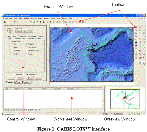
1. CARIS LOTS™ Interface:
2. Basic Operations
Basically CARIS LOTS™ employs the same operational procedure as other windows-based GIS software. It is not very difficult to understand basic operation such as:
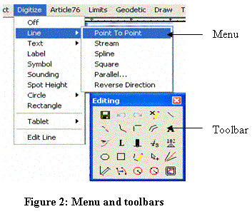
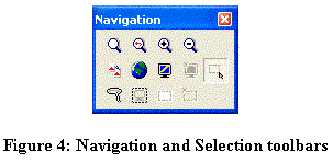
a. Switching between menu and toolbar command
b. Open and closing map [file >> open]

c. Navigation (zoom, pan, scroll) and Selection (single, multiple, all)
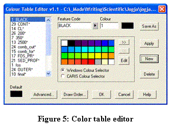
d. Color setting [Tools >> Colours…]
e. Set Filter (viewing only desired feature[s])

3. CARIS LOTS™ existing data (Caris Digital Atlas, CDA)
By default, CARIS comes with three kinds of high resolution data that can be used to exercise maritime claims. The three types of data are:
a. Global Seafloor Topography from satellite altimetry (2-minute bathymetric data, covering 72°N to 72°S with 50,000,000 soundings.
b. Etopo2 data has complete global coverage with bathymetry data coverage of 60,000,000 soundings and land cover of 20,000,000 spot heights.
c. The World Vector Shoreline (WVS) at a nominal scale of 1:250000, contains shorelines, international boundaries, and country names of the world.
Maritime Boundary Delimitation and Dispute Resolution: A Scenario
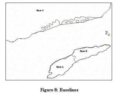
States in disputes are simulated as three States in a neighborhood: A, B, and C (see figure 1 bellow). States A and B are adjacent and C is opposite to both A and B. State B owns Island P that situates between State B and State C. Between State A and B, an adjacent maritime boundary has to be delimited , which is quite straight forward. Both state A and B use normal baseline. Meanwhile State C has fringing islands and irregular shape of coastal line. It has to employ combined baselines: normal and straight baseline. In delimiting maritime boundary between C and B, Island P has to be considered. The island can be given zero effect, half effect or full effect, which depends on relevant factors considered. Each scenario will generate different composition of boundary line.
In delimiting maritime boundary between A and C, an oil-rich block between them has to be considered. Based on negotiation, both states agree to have a joint-development area. This causes a gap that breaks the boundary line between State A and C.
1. Nautical Chart

Chart can be imported from the CARIS existing data or obtained locally from an authorized body (for Indonesia: Bakosurtanal, Dishidros). It is also possible to import from shape file (ESRI file), ASCII, or geo-referenced raster data. CARIS LOTS™ is also equipped with geo-referencing feature for a non-geo-referenced raster data (e.g. TIFF -> GEOTIFF).
2. Normal Baseline, Straight Baseline
There are two types of baselines demonstrated above. For state A and B, normal baselines -the line depicting low water line- are used. For state C, combinations of normal baseline and straight baseline are used. Straight baselines need to be employed because of the condition of its coast line. Some part of coast line is deeply cut into while some part is fringed with islets.
3. Robust Median Line Construction
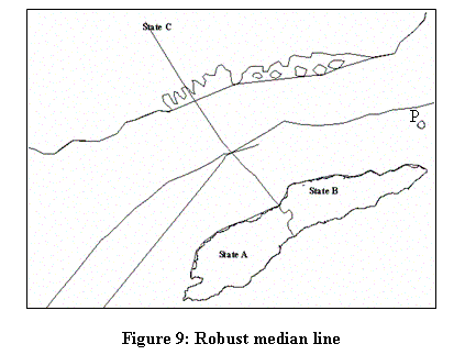
An equidistant line is generated between state A and B heading north. The generation of median line between States A and State C has not yet considered JDA. Similarly, State B-State C median line has not either considered Island P.
4. Weighting
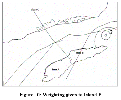
Different weight assigned to Island P produces different combination of median line. The above figure shows three different weights/effects given to Island P: zero effect, half effect and full effect.
5. Finalization
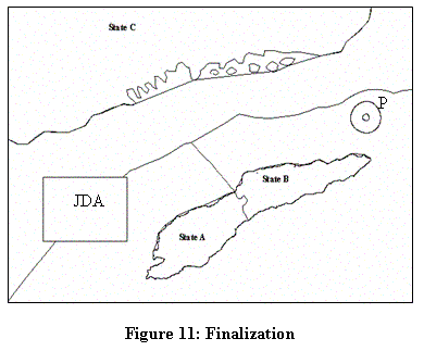
Joint Development Area is added between State A and C causing a break in the median line. Between State B and C, the line agreed is the one giving half effect to the Island P. Final line is to be achieved by mutual bilateral agreement among/between states in question.
Footnotes
1Presented in a workshop organized by Bakosurtanal-FT UGM, Yogyakarta, 6-7 May 2005
2 Lecturer in the Department of Geodetic Enginering, a researcher in the Center for Boundary Studies Bakosurtanal-FT UGM, currently pursuing postgraduate research study in the University of New South Wales, Sydney madeandi@ugm.ac.id More...
