I Made Andi Arsana 2
School of Surveying and Spatial Information Systems
The University of New South Wales
madeandi@student.unsw.edu.au
Abstract
During March 2005, bilateral relationship between Indonesia and Malaysia escalates. The rising matter relates to Malaysia’s claim over Ambalat area located in the east of Borneo Island, while Indonesia, in the other side, is sure the area belongs to Indonesia.
Reactive responses come from most of Indonesians because they, generally, believe that it is another manifestation of Malaysia’s greediness. This is understandable since Malaysia won the case on Sipadan and Ligitan (two islands located near Ambalat) over Indonesia in 2002 causing Malaysia successfully took the two islands
3. No matter what the reasons the ICJ proposed in deciding the case, most of Indonesian citizens are simply disappointed. Since such case is very sensitive, with regards to Ambalat case, people from both countries have to really understand the problem in terms of science, technique, and law.
This paper discusses the case of Ambalat in a spatial perspective and is aimed to provide better understanding for people especially the laymen. This will discuss briefly the principles of international maritime boundary; the history of Indonesia-Malaysia boundary; the latest status of Indonesia-Malaysia boundary, especially maritime boundary; status and problems of the Indonesia-Malaysia maritime boundary in the Celebes Sea; and an idea for Ambalat conflict resolution from the spatial point of view. Lastly, this ends with conclusion and suggestions.
IntroductionMass demonstrations in some regions in Indonesia generally protest Malaysia’s claim over Ambalat. The reactive responses become uncontrolled since some actions headed to be radical and even anarchy by burning Malaysian flag and even Malaysian pretty singer’s photo: Siti Nurhalisa. She is actually nothing to do with Ambalat.
War even took place in virtual world: Internet, indicated by the defacing of some Malaysian and Indonesian official websites. Arguing each other gets worse and unfortunately most of the arguments are based on emotional considerations, not a comprehensive understanding to the real problems. Without purpose to blame either Indonesians neither Malaysians, because both countries have not yet agreed upon the case, I am quite sure that lack of comprehensive understandings to the case potentially causes mistakes in making decision.
International Maritime Boundary: A BriefingInternational maritime boundary is governed by the international law, especially the regime of the law of the sea. The United Nation even generated a convention that regulates this particular matter called the United Nation Convention on the Law of the Sea (hereinafter referred to as LOSC) in 1982. Every coastal or archipelagic State that has ratified LOSC is entitled to maritime zones measured from its baseline. Figure 1 illustrates maritime zones a coastal state may claim.
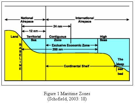
The above figure shows that maritime zones are measured form baseline to a certain distance in the unit of nautical miles (nm). Maritime zones include territorial sea at a distance of 12 nm from baseline, contiguous zone for a maximum distance of 24 mil, Exclusive Economic Zone for 200 nm and Continental Shelf that measured for a distance of no more than 350 nm from baseline
4.
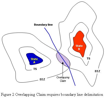
Imagine there are two coastal states separated in a distance of less then 300 nm each other, there will be an overlapping claim for EEZ. At this stage, a boundary line is required. See figure 2 for illustration.
By ratifying the LOSC through the Law no. 17/1985, Indonesia obligates to define its international boundaries and depict them in a sufficient-scale nautical chart to strengthen its position. Technically, it should have started by definition of basepoints of its archipelagic baselines
5, continued by the definition of internal waters, territorial sea, ZEE and Continental Shelf that are depicted in a nautical chart employing particular geodetic datum
6. After that, the map must be deposited to the UN Secretary General to obtain legal recognition. This, actually, has been regulated in the Law No. 6/1996 about Indonesian Waters (Wikantika, 2005). However, Indonesia has yet finished none of the ten potential maritime boundaries with neighboring states (Tarmansyah, 2003). The neighboring states are Australia, Malaysia, Philippine, Singapore, Palau, India, Thailand, Vietnam, Papua New Guinea, and East Timor.
Since Malaysia has also ratified the LOSC (Syarif, 2005 in Kompas, 12 March 2005), the same procedures should have been proceeded. If the 1979 map Malaysia used to claim Ambalat has not yet deposited to the UN Secretary General, or even if it has not been regulated in its internal law, then Malaysia’s claim over Ambalat is not legitimate.
The History of Indonesia-Malaysia BoundariesBefore stepping into Ambalat case, it is necessary to briefly look back into the history of Indonesia-Malaysia boundary. Discussion on boundary of the two states, undoubtedly, cannot be separated from the colonial history of the Great Britain and the Netherlands over Borneo Island long time before the independence of Malaysia and Indonesia.
The 1891 Convention is a convention between The Great Britain and the Netherlands to divide Borneo Island into two regions: the northern part belonged to The Great Britain and the southern part was the Netherlands’. Since the independence era, Malaysia has been the successor of Britain and Indonesia has been continuing the Netherlands’ regime. In defining their boundary, especially land boundary, both countries have to refer to the 1891 Convention agreed by The Great Britain and the Netherlands.
Land boundary between Indonesia and Malaysia is clear since the convention has clearly defined the line. This following figure is a satellite image depicting land boundary between Indonesia and Malaysia in the eastern part of Borneo.
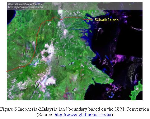
The figure illustrates that the land boundary line crosses Sebatik Island. The line crosses the latitude of 4° 10’, approximately 450 km north of equator. Unfortunately, the line stops at the eastern edge of Sebatik Island, so that the ownership of small islands and area located in the East of Sebatik is unclear. This is one of the problems causing Indonesia “loss” two islands: Sipadan and Ligitan.
The Latest Status of Indonesia-Malaysia Maritime BoundariesThe maritime boundary with Malaysia was the first one Indonesia negotiated with its neighboring State. A boundary treaty was even established and came into force on 7 November 1964 (Forbes, 2001: 74). However, the boundaries have not been fully accomplished until today. It is noted that there are three locations of maritime boundaries between Indonesia and Malaysia: Malacca Strait, South China Sea, and Celebes Sea (Prescott, 2004), where Ambalat lays. Boundaries in the first two locations have been established partially, resulting in three segments of boundary lines. The first segment is in Malacca Strait going down close to Malaysia-Singapore boundary with total distance of 400.8 nm. The second segment starts in the eastern side of Singapore Strait going up to South China Sea. The last segment is the continuation of land boundary at Tanjung Datu, the Northwest part of Borneo (Forbes, 2001: 76). Following figure illustrates the boundaries in the first two locations taken from Forbes (2001).
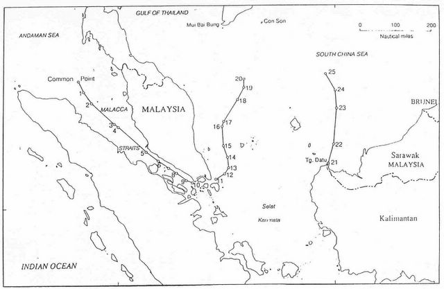
Figure 3.a Indonesia-Malaysia Maritime BoundariesMaritime Boundary in Celebes Sea: Status and ProblemsAccording to Villanueva (2005), the overlapping claims of territorial sea boundary, EEZ boundary and Continental Shelf boundary around Ambalat area or Celebes Sea have not yet been fully agreed. These have to be established through a bilateral negotiation between Indonesia and Malaysia. Jinangkung (2005)
7 stated that Indonesia is actually ready to conduct any negotiation and even already started the negotiation on 22 March 2005 with Malaysia. Even though it seemed to be related to Ambalat case, he asserted that the negotiation was a scheduled negotiation and would generally discuss Indonesia-Malaysia unresolved boundaries in the three locations: Malacca Strait, South China Sea and Celebes Sea.
Ambalat
Many people do not precisely aware the position of Ambalat. Some even do not realize that Ambalat is not an island but water area/block located in the east of Borneo. Besides Ambalat, the block is also known as Block ND6 and ND7.
According to discussion on this matter in an internet-based community, RSGIS Forum, Ambalat is a block located in the area with coordinates of 118°15'21" - 118°51'15" E and 2°34'7" - 3°47'50" N. Having assumed that the coordinate is accurate, Ambalat lays from South to North at a distance of 65 km and 135 km from West to East. This also means that the block situates bellow the border line crossing Sebatik Island. Relative to Sipadan and Ligitan, Ambalat situates closer to Borneo. Two figures bellow respectively show the location of Ambalat and its position relative to Sipadan and Ligitan.

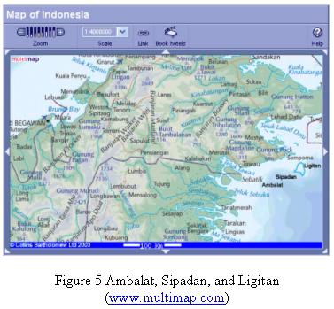
It is worth noting that the ICJ’s decision to grant Sipadan and Ligitan to Malaysia may change the configuration of Malaysia’s baselines. This can influence maritime zone it may claim. In the other words, it is highly possible for Malaysia to claim larger maritime zones southward to Indonesia. This, according to some sources, is one of the strengths for Malaysia to claim Ambalat.
Conflict Resolution: A Rough IdeaAs previously mentioned, a bilateral mutual agreement between Indonesia and Malaysia is required to resolve conflict on boundary case. It is obvious that Ambalat case is a maritime conflict because Indonesia and Malaysia claim the same maritime zones (overlapping claim) where the block situates. Villanueva (2005) asserted that this is not the case of full sovereignty but limited sovereignty to explore and exploit maritime zone and natural resources deposited there. This is different compared to the case of the ownership of an island.
Before deciding to start a negotiation, Indonesia obligates to conduct comprehensive studies, which technically has to be initiated by the National Coordinating Agency for Surveys and Mapping (Bakosurtanal) and The Indonesian NAVY’s Hidro-Oceanographic Office (Dishidros TNI-AL) with coordination with the Department of Foreign Affairs.
Following are technical steps that might be considered in resolving Ambalat case.
- Baselines Definition
It has to be anticipated that Malaysia may change its baseline configuration because Sipadan and Ligitan are now officially theirs. Defining Indonesia and Malaysia’s baseline in Celebes Sea is the first step to do as reference for measuring maritime zones. Indonesia, will, of course, preserve its archipelagic baselines.
- Definition of EEZ and Continental Shelf Boundary
The second step is to define the boundary for EEZ and Continental Shelf. It will be found that Ambalat situates in EEZ and Continental Shelf of both States. The case deals with Continental Shelf since it relates to the exploration and exploitation of seabed.
- Maritime Boundary Delimitation
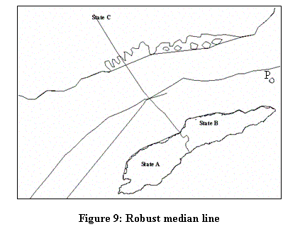
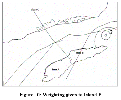
The overlapping claim in the EEZ and Continental Shelf requires maritime boundary delimitation. It has been widely accepted to employ equidistance/median line to generate a boundary line, at least as a starting point. After that, it needs to consider contributing factors/aspects to achieve an equitable solution. Factors that need to be considered are proportion of coastal length involved, and socio-economic development of both sides.
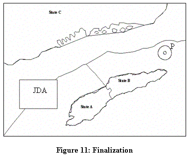
- The possibility to establish Joint Development Area
If the delimitation divides Ambalat into two different parts, each country can only explore and exploit its own part. Another possibility is to establish a Joint Development Area, similar to what agreed by Indonesia and Australia in the Timor Gap. The urgent matter that needs to agree upon is the management and sharing rules for each side.
Technical steps described above can be done by employing in situ survey or cartographically using nautical chart and satellite image in a sufficient scale.
Closing RemarksHaving considered the above analysis, it can be concluded that:
- Ambalat case is a limited sovereignty conflict because both Indonesia and Malaysia try to claim the same maritime zone (overlapping claim).
- A good understanding in term of science, technique and law is essential, not only for government officials but also ordinary people from both sides, to avoid emotional decision.
- This requires synergy among related departments, agencies, boards, etc. to comprehensively study the case before deciding to negotiate the case bilaterally or submitting the case to the International Court of Justice.
The case involving Sipadan, Ligitan, Ambalat and other similar cases related to International Boundary should have reminded Indonesia, as a nation, to seriously pay attention to maritime boundary delimitation. Another urgent step is to list small islets all over Indonesian Archipelago, and to name (toponim) every single islet. This, actually, has been conducted by the Department of Marine Affairs and Fisheries since quite a long time. To speed up the process, as opined by Wikantika (2005) Remote Sensing technology can be employed using satellite images. By finishing these all urgent “homework”, hopefully Indonesia gains more strength to preserve its sovereignty and can negotiate confidently whenever a case regarding maritime boundary arises.
Footnotes1Delivered in an open discussion by Indonesian Students at UNSW, Sydney, 29 March 2005
2A Lecturer at Department of Geodetic Engineering, UGM, currently studying technical aspect of International Maritime Boundaries
3see also http://www.icj-cij.org/icjwww/ipresscom/ipress2002/ipresscom2002-39_inma_20021217.htm about the ICJ’s judgment on this case
4Detail regulation for each maritime zone can be found in UNCLOSS III document. Online access: www.un.org/Depts/los/convention_ agreements/texts/unclos/unclos_e.pdf
5Three types of baselines: normal baseline, straight baseline, and archipelagic baseline. The last type is applicable to Indonesia because it is an archipelagic state.
6Datum is a reference position for an object on earth. A map must have an official datum and is scientifically acceptable in an area. Two maps used together for common purpose must have the same datum.
7L. Amrih Jinangkung is a staff of the Indonesia’s Department of Foreign Affairs, Directorate of Treaties on Political Security and Territorial Affairs. Communication with author was done by email.
ReferencesForbes, V. Louis, (2001), Conflict and Cooperation in Managing Maritime Space in Semi-Enclosed Seas, University of Hawaii Press
Prescott, Victor (2004), Maritime Delimitation in Southeast Asia: The Case of Indonesia
Schofield, C. (2003) Maritime Zones and Jurisdiction, 2003 ABLOS Conference, available: http://www.gmat.unsw.edu.au/ablos/ABLOS03Folder/SESSION3.PDF
Syarif, Laode M., (2005), Pesan buat Syed Hamid Albar, Kompas,12 maret 2005
Tarmansyah, Umar S., (2003), Lepasnya P. Sipadan Dan P. Ligitan Sebuah Pelataran Kewaspadaan, Buletin Balitbang Dephan No 10
Villanueva, Klaas J., (2005) Satu Pandangan/Ulasan: Sengketa Wilayah ZEE Dan Wilayah Landas Kontinen di Ambalat
Wikantika, Ketut, 2005, Mereinventarisasi Pulau-pulau Terluar Indonesia Citra Satelit Kurangi Biaya Survei, Pikiran Rakyat, 17 maret 2005
More...


 - Opinion and Editorial, December 19, 2005
 Ashmore reef (a.k.a. Pulau Pasir) is currently being disputed by Indonesia and Australia.
 It is the third or fourth lecture I gave in the Center for Maritime Policy in the University of Wollongong. The lecture is a very good experience for such a young academic like me. Not only it gives me money :) but also provides me with opportunity to build a strong network for my carrier in the future. I met some top guys from Indonesian goverment institutions and have made very good contacts. See
 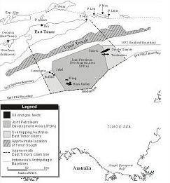 Still remember
  Being the only surveyor presenting in a social science conference is an interesting experience. The Indonesia Council Open Conference, 2005 is an annual conference hosted by Flinders University in Adelaide with the support of The Flinders Asia Centre and the Inside Indonesia magazine, where my presentation is the only technical paper among many social papers presented. Being a social science conference, almost all presentations are about to social issue, especially, of the Indonesian society.
 Map Asia 2005 is the 4th annual conference organized by GIS Development PTE. Ltd. - Singapore in collaboration with Indonesia’s Bakosurtanal, Asosiasi Perusahaan Survey dan Pemetaan (APSPI ) – INDONESIA, Center for Science, Development and Media Studies (CSDMS) - India,and the Asian Institute of Technology - Thailand. The conference was undertaken in Mulia Hotel, Jakarta Indonesia on 22-25 August 2005. Bellow are some important notes about the conference.
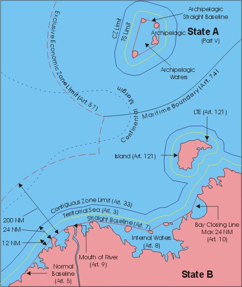


 I Made Andi Arsana [The Jakarta Post] The local leadership elections currently taking place are one of the most important current issues in Indonesia.


