
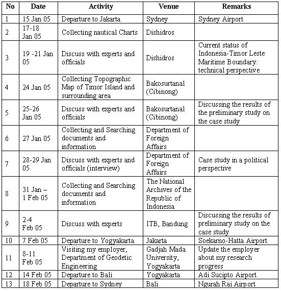
20 December 2004
Jo Ronalds
UNSW AusAID Liaison Officer
Dear Jo,
I am writing with regards to my plan to attend a software training conducted by my school, the School of Surveying and Spatial Information Systems, UNSW on February 21 – 25, 2005. The training is about the application of CARIS LOTS™ (see http://www.caris.com/products/product.cfm?productID=15) in maritime boundary delimitation. My school will invite a professional trainer from CARIS (http://www.caris.com), Canada to provide a tailored training, which will be open for public.
As you might know, my research is about the delimitation of maritime boundary between Indonesia and Timor Leste which will use the above mentioned software to generate the boundary lines. As the software is a new kind of software to me, it is clear that the training will be essential to accomplish my research. In addition, the training will be the first CARIS LOTS™ training conducted in Australia. For sure, it is going to be a good opportunity for me.
As part of the scholarship agreement, I kindly request AusAID to support me to attend the training by providing funds for the registration. Enclosed is an email from the trainer containing training details. A recommendation letter from my supervisor, Dr C. H. Schofield will be sent to you separately by email.
Thank you very much for your attention and cooperation. I am looking forward to hearing from you in the near future.
Yours sincerely,
I Made Andi Arsana
Student ID: 3082390
 Karya I Made Andi Arsana, ST., ME
Batas Maritim Antarnegara - Sebuah Tinjauan Teknis dan Yuridis
(Gadjah Mada University Press, 2007) more...
Karya I Made Andi Arsana, ST., ME
Batas Maritim Antarnegara - Sebuah Tinjauan Teknis dan Yuridis
(Gadjah Mada University Press, 2007) more...Monday, December 20, 2004
Letter to AusAID for Software Training
Response from Bakosurtanal
[calling pak sobar]
I haven’t mentioned that I got response from Bakosurtanal, have I? Bakosurtanal is an important institution I will visit during the fieldwork. I called Dr Sutisna (hereinafter referred to as Pak Soabar), head of the center for Boundary Mapping of Bakosurtanal. He answered my called warmly with his friendly “assalamualaikum”. Without doubt, I simply replied “walaikumsalam” followed by introduction. It did not take long for him to remember me when I said “Madé UGM”. He just did not realise that I called from Sydney because the strange number appeared on his mobile was [like] a Jakarta number.
Pak Sobar responded positively when I told him my plan to visit Bakosurtanal for obtaining data (topographic map). Only, he will not be around at the day (24-26 January 2005) for he will be in Mekah for “Ibadah Haji”. It doesn’t matter because, according to him, Bu Sari can help me to obtain the data. “Just lest us know your detail plan and data you need, Bu Sari will help you. You’ve known her haven’t you?”, he added.
I hope this journey can enrich my academic experience as well as strengthen the network I am currently developing.
Friday, December 10, 2004
One hour with Hasanudin Z. Abidin
[six-point suggestions]
Today, I have a chance to talk to Hasanudin Z. Abinin, the top-notch GPS guy from Indonesia. He was also one of the key persons who have conducted preliminary research on maritime Boundary delimitation between Indonesia and Timor Leste. I just “use” the chance to talk to him while he is visiting our school for the GNSS 2004 conference.
Hasan emphasized at least six (6) items I have to consider:
- The effect given to the small island (Kisar) that belongs to Indonesia located up-right of Timor Island. According to Hasan, it is possible for TL to ask Indonesia to give a half (or even less) effect to the island because it is very small compared to the whole TL. However, it is also possible for Indonesia to negotiate because the island should not be compared to the whole TL but to a similar island belongs to TL (Jaco) which is located near the island in question. If TL insists to consider the whole TL, Indonesia can argue to consider the whole Indonesia as well, which is undoubtedly, significantly larger than TL.
- The baselines pulled from Liran Islet (or island) which is located at the west of Wetar Island to Alor Island can be the part of archipelagic baseline which technically is straight baseline. However, it is not possible because it will cross the Internal Water of TL because one of TL’s islands, Atauro, which is located between Liran and Alor, will generate its own maritime zone. Concerns need to be given to this particular case.
- With regards to Oekusi, it will be difficult for Indonesia to draw baseline. According to Jalal, Indonesia is entitled to draw archipelagic baseline which is closed. This means Indonesia can pull the line from a point at Alor Island to one of common basepoints located at Timor Island, somewhere in the land borderline between Atapupu and Balibo and continue it along the coast until Wini. From the point the line can be drawn up to a point at Alor Island, continued to Pantar Island and down again a point at Citrana (see red line in the figure bellow). Jalal claimed that it is possible to draw such a line because, as mentioned previously, archipelagic baselines should be closed and the straight sections it produces do not exceed the limit, 125 n.m.
- The ownership of Batek Island. Orally, TL admitted that Batek belongs to Indonesia but when Indonesia asked TL to state it formally, TL refused it. The ownership of Batek Island will significantly influence the definition of maritime boundary because Batek, as an island, can generate its own maritime zone.
- The definition of Common Basepoints. Indonesia has defined its basepoints and those are regulated by PP 38/2002. However, the regulation does not include common basepoints. This research must simulate the location of common basepoints base of the rule and constraints in defining basepoints.
- TL basepoints. TL has not yet its basepoints along the northern coast. This means that to be able to draw the boundary line, it is necessary to define TL’s basepoints.
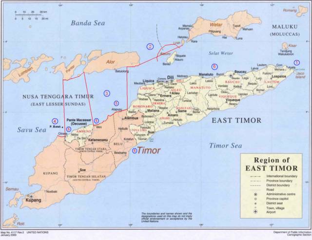
Adapted from: http://www.defence.gov.au/army/asnce/images/timor_map.jpg
More...
Monday, November 22, 2004
Excellent!
[Chris's supports]
I met Chris today after previously canceling two appointments with him.
Basically we discussed my proposal and the plan to conduct fieldwork in Indonesia. Chris gave a very encouraging comment concerning my proposal. He confirmed that I've covered everything perfectly in the proposal that impresses him.
Chris paid attention to the section explaining the Geographic Information Systems and he suggested me to come to Canberra to visit the Australian Maritime Boundaries which is part of Geoscience Australia. He was sure that I can see much things related to the application of GIS in Maritime Boundary. What the group has done, will enrich my insight about how GIS is used in managing Maritime Boundary data. I will ask Clive to take me there whenever he comes there to see one of his PhD students.
I personally asked Chris whether I can start writing a paper related to my research and publish it in a journal or conferences. He supported me to do so, but he does not know much what I can write in the law of the sea topic and where I can publish it. For this reason, he suggested me to discuss with Clive. He prefer me to write a paper about the application of GIS in Maritime Boundary. Shortly, he encouraged me to write something related to Geomatics and he will support me to publish it in a converence or journal.
We also discussed posibilities to extend my study into a PhD level and he told me that there are two possibilities. Firstly, if possible, I can transfer my study from master level into PhD level by adding one or two more years of study period. This means that I will not get Master degree, but only PhD. Secondly, I have to finish my master first and then start to develop a new proposal for PhD. In this case, the topic must be completely different. However, Chris asked me to talk furher about this particular matter to Clive. He thought that Clive might know better then him concerning the topic and its adquacy to proceed a PhD level.
Despite all the talks about study and extensions, money does matter. To find a sponsorship is another problem I should deal with.
Anyway, I am really happy with Chris's response today. I am sure that his positive comments and supports will help me much in accomplishing the research.
Friday, November 19, 2004
Response from National Archives
Similar to DEPLU and Dishisdros, the National Archives of Indonesia also gave a positive response to my plan doing research there. They also expected me to provide a letter addresed to the section of Archive Service.
Yes, that is what experts call "Normal Baseline"
Finally I've managed to finish all the "dispute" about NORMAL Baseline. Figure in entry on November 4, 2004 is the correct Normal Baseline. Clive also confirmed that the picture looks nice and correctly depicts the baseline.
It is important to understand some terms:
* Low Water Elevation
* Low Water Line
Please see here for details.
Wednesday, November 17, 2004
Fieldwork or holiday?
I am so happy today.
My journey to Jakarta will enable me to stop over in Bali for one night. This is because the flight to Jakarta will be through Denpasar and it is possible to stop over. However, I need to pay $55 for that because AusAID does not provide funds for 'holiday' but It doesn't matter.
I've confirmed my flight schedule to STA and the following are the details:
- 15 January 2004 -> Sydney to Denpasar
- 16 January 2004 -> Denpasar to Jakarta
- 7 February 2004 -> Jakarta to Yogyakarta
- 14 February 2004 -> Yogyakarta to Denpasar
- 18 February 2004 -> Denpasar to Sydney
More...
Saturday, November 13, 2004
Response from DISHIDROS
[thanks to Mas Yazid]
I finally know that there is an Alumny of Geodetic Engineering in DISHIDROS. His name is Mamad Yazid who entered UGM in 1988. He personally supported me to conduct fieldwork in DISHIDROS and promise me to give any data I need.
Because of our personal relationship, he even did not request me to provide a formal letter. However, I think it is agood idea to have one and Clive already agreed to write a letter for me.
Friday, November 12, 2004
My Fieldwork Approved!
An email from Jo:
Dear Andi
Thank you for your email.
Today a letter approving your fieldwork was mailed to you. I have provided
STA with a copy of the letter, and your schedule so that they may make the
booking. I have also asked that the most flexible ticket possible be
booked for you. I would recommend that you contact them next week to
confirm the details of the booking.
In regard to your training, the same documentation is required as
previously requested.
Kind regards
Jo
Thursday, November 11, 2004
CARIS training on February 2005
Finally, we've come up with a solution.
The training will be held on February 2004 after the fieldwork. We plan to do it on February 21-25, 2005. Hopefully, no obstacle raises.
See you next year!
Wednesday, November 10, 2004
Respons from DEPLU
[thanks to Mr. Jinangkung]
I've tried to contact The Department of Foreign Affairs of Indonesia for the fieldwork. Positively, Mr Amrih Jinangkung gave a response and told me to prepare a letter. There, I will be dealing with the Director-General for Multilateral Political, Social and Security Affairs of the Department of Foreign Affairs.
Amrih also indicated that his directorate might not be able to provide all data I need but he promise me to introduce me to other sections which probably can support my research. He also adviced me to provide a short letter signed by Clive saying that I am a research student at UNSW and need to do research at the Department of Foreign Affairs.
For communication purposes, Amrih can be contacted by email aung01@hotmail.com or telephone +62213849618.
Friday, November 05, 2004
CARIS LOTS training - rescheduled!
I've got an email from Clive:
=================
One hitch is that Rob van de Poll has now said he cannot do the dates we discussed. I am therefore thinking about the second week of January (i.e. just before you plan to go away on the 15th). Would that be OK with you?
=================
bellow is my reply:
=================
I am afraid, may not be available on the second week of January. I
plan to go to Brisbane for vacation and I've booked tickets for us
(Asti and me). How about doing it earlier, let's say on the first or
second week of December?
Or, if it is not possible at al, I will cancel my ticket. I don't
think we have other way out, do we?
=================
Thursday, November 04, 2004
Is it the Correct Normal Baseline?
Do you think it is a corect illustration of normal baselines?
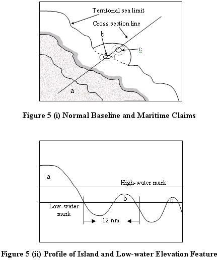
where:
a : island
b : low-tide elevation that creates its own territorial sea
c : low-tide elevation that does not create its own territorial sea
Figure 5 (i) shows an island (a) with low-water line serving as a normal baseline. From the normal baseline, the limit of the territorial sea is measured seaward to the breadth of 12 nm. Since there is a low-water elevation feature (b) lies within the distance of 12 nm, it can be used as territorial sea basepoints (Carleton and Schofield, 2001: 23) and can generate its own territorial sea. On the other hand, another low-water elevation feature (c) does not generate its own territorial sea because its distance is more than 12 nm from the mainland. Figure 5(ii), showing the profile of the island and low-water features, better illustrates the distance from the mainland seaward. It also shows the definition of low-water elevation feature; the feature that is depicted above the water surface at the low-water.
Tuesday, November 02, 2004
Normal Baseline - a correction
Look at the figure bellow. "This is not the way you draw the normal baseline", says Clive.

Explore more in the United Nation Handbook on the Delimitation of Maritime Boundaries and TALOS document[s]
Friday, October 29, 2004

Letter to AusAID for Fieldwork
29 October 2004
Jo Ronalds
UNSW AusAID Liaison Officer
Dear Jo,
I am writing with regards to my plan to conduct a fieldwork in Indonesia during January-February 2005. This fieldwork is a part of my research towards the Masters Degree in Engineering at the University of New South Wales, Australia.
As part of the scholarship agreement, I kindly request AusAID to support my fieldwork in Indonesia by providing funds for international and relevant local (in Indonesia) transports. Enclosed are my supporting documents which include: fieldwork outline; fieldwork schedule and itinerary, and a recommendation letter from my supervisor Dr C. H. Schofield.
Thank you very much for you attention and cooperation. I am looking forward to hearing from you in the near future.
Yours sincerely,
I Made Andi Arsana
Student ID: 3082390
Wednesday, October 27, 2004
Fieldwork Outline
[ a journey plan]
Research Description
Research Title : Critical Study on the Technical Aspects of the Maritime Boundary Delimitations: A Case Study of the Maritime Boundary Delimitations between the Republic of Indonesia and the Republic Democratic of Timor Leste
Researcher : I Made Andi Arsana
Student Number : 3082390
Address : 2/10 Houston Rd, Kensington, 2033, NSW
Telephone : (02) 96626023.
Email : madeandi@student.unsw.edu.au
Degree : Master in Engineering
Supervisor : Professor Chris Rizos
Co-supervisor : Dr. Clive Schofield
Introduction
The current research project concerns the study of the technical aspects of maritime boundary delimitation using the Indonesia-Timor Leste Maritime Boundaries as the case study. This research aims to conduct a critical analysis of this case study in order to define possible maritime boundary delimitation options between Indonesia and Timor Leste and in so doing highlight potential challenges to delimitation and how to overcome these obstacles. Several alternatives of maritime boundary delimitations are expected to be the results as well as the advantage and disadvantages of each alternative solution.
To conduct this research, data and supporting information are essential, which will be collected by conducting a fieldwork to Indonesia. Data will be obtained from relevant departments and agencies through formal procedures. Some data and information may be obtained for free, while some will need to be purchased.
Fieldwork Objectives
The objectives of the fieldwork are:
- Collecting key data; nautical chats, and topographic maps.
- Searching for and collecting information and relevant documents related to the current status of maritime boundary delimitation between Indonesia and Timor Leste.
- Meeting the Indonesian experts and government officials in maritime boundary at Bakosurtanal, Bandung Institute of Technology, Gadjah Mada University, and the Indonesia’s Department of Foreign Affairs; and
- Updating/informing research progress to the Researcher’s home institution, Gadjah Mada University.
Fieldwork activities and their Relationship to the Research
- Obtaining recognized nautical charts of Timor Island and surrounding are from the Indonesian Hydrographic Office (Dishidros).
This chart will be the main source of data to draw the basepoints, baselines, maritime zones and maritime boundary lines. - Obtaining topographic map of Timor island and surrounding area from the National Coordinating Agency for Surveys and Mapping (Bakosurtanal);
This is to identify the location of Timor Island and other islands and islets located around Timor Island. Knowing the geographic location of the area in question is essential for the current research. - Searching for and collecting information and relevant documents related to the current status of maritime boundary delimitation between Indonesia and Timor Leste from the Indonesia’s Department of Foreign Affairs and the National Archives of the Republic of Indonesia.
Maritime boundary delimitation is a sensitive political process. It is important to know the history of the maritime boundary delimitation between Indonesia and Timor Leste, as well as the efforts that have been done to establish the maritime boundaries. This information is obtained from relevant official documents. - Meeting the Indonesian experts and government officials in maritime boundary at Bakosurtanal, Bandung Institute of Technology, Gadjah Mada University, and the Indonesia’s Department of Foreign Affairs;
This activity will help me as a researcher to know the latest issues and researches in the related field that have been undertaken previously by Indonesians experts, especially the current status of Indonesia-Timor Leste maritime boundaries. This information will be obtained from relevant official documents and interviews with key personnels - Meeting the researcher’s employer at Gadjah Mada University
This activity is to inform the employer about my research progress. This is important because after finishing the study, I am expected to go back to the same institution, continuing my obligation as a lecturer.
Fieldwork Schedule and Itinerary
Addresses:
- Dishidros: Jln. Pantai Kuta V/1 Ancol Timur Jakarta – Indonesia Phone: 62 21 64714810, Fax: 62 21 64714819, E-mail: infohid@indo.net.id
- Bakosurtanal: Jl Raya Jakarta-Bogor Km 46 Cibinong 15911 Phone: , Fax: , e-mail: pbw@bakosurtanal.go.id
- ITB (Department of Geodetic Engineering): Jl. Ganeça No. 10, Bandung, 40132 Phone: 62 22 2530701, Fax. 62 22 2530702 E-mail: dtgd@gd.itb.ac.id
- Department of Geodetic Engineering (UGM): Jl. Grafika No. 2, Yogyakarta, 55281, Indonesia Phone: 62 274 902121, Fax: 62 274 520226, E-mail: geodugm@idola.net.id
Friday, October 22, 2004
The second draft - my proposal
Finally, I've finished writing my second draft. Is a combination of my own idea and Clive's suggestion. I've just sent him a copy. I hope he can correct it as soon as possible.
hm... it is nearly the end of october.. I must work harder :)
Tuesday, October 19, 2004
CARIS Training Dec 13-17 2004
It is decided that we are going to conduct the training during in December 13-17 2004. It's gonna be the first CARIS LOTS training in Australia... hmm can't wait!
More...MARINE SCIENTIFIC RESEARCH: A LEGAL AND TECHNOLOGICAL PERSPECTIVE
I Made Andi Arsana [1]
Abstrak
Banyak ahli mengatakan bahwa Bumi identik dengan Planet Air. Hal ini karena dua pertiga permukaan bumi tertutup oleh laut. Berbagai usaha telah dilakukan untuk mendapatkan sebesar-besarnya manfaat dari laut dalam kurun waktu setengah abad terakhir. Usaha ini dilakukan diiringi dengan perkembangan teknologi yang memungkinkan manusia untuk mengeksplorasi dan mengeksploitasi sumberdaya kelautan. Pelaksanaan penelitian ilmiah kelautan (PIK) adalah salah satu usaha untuk menambah pengetahuan tantang sumberdaya kelautan.
PIK dan pengembangan teknologi menjadi dua hal yang saling berkaitan dan mempengaruhi. PIK akan meningkatkan perkembangan teknologi dan sebaliknya perkembangan teknologi memungkinkan dilakukannya PIK yang lebih mutahir. PIK yang ekstensif tentu saja memerlukan regulasi untuk menjamin penelitian dilakukan dengan cara yang benar. Hal inilah yang mendorong dibentuknya aturan hukum yang menangani masalah PIK. Dalam hukum internasional, Konvensi Hukum Laut PBB (LOSC), khususnya Bagian XIII, adalah peraturan yang menangani masalah PIK.
Tulisan ini akan membahas penelitian ilmiah kelautan dalam perspektif hukum dan teknologi yang mencakup konsep dasar PIK; peraturan hukum tentang PIK; tren atau kecenderungan PIK dewasa ini; penggunaan teknologi dalam PIK; PIK dan geomatika; dan terakhir tentang hubungan antara Konvensi Hukum Laut dengan PIK.
Kata kunci: penelitian ilmiah kelautan, hukum laut, geomatika, teknologi
Abstract
Planet earth is identical to the Planet of Water because two-third of its surface is covered by ocean “blanket”. Efforts to get the most out of the ocean have been done extensively over the last half of 20th century. This is done along with the advancement in technology, which enable mankind to explore and exploit the ocean’s resources. Marine scientific research (MSR) is one of the efforts to get more knowledge on ocean resources.
MSR and technology development have been becoming mutual parties which influence each other. The results of MSR enable people to enhance technology to conduct more advanced MSR. However, an extensive MSR needs to be regulated to make sure it is done properly. This challenges the establishment of the legal regime in MSR. The United Nation Convention on the Law of the Sea (LOSC), especially Part XIII, is the international law that governs MSR.
This paper discusses marine scientific research in the legal and technological perspective that covers the concept of MSR; legal regime of MSR; trend in MSR; the use of technology in MSR; MSR and Geomatics; and finally discussion about the relationship between LOSC and MSR.
Keywords: marine scientific research, law of the sea, geomatics, technology
Introduction
Some experts claim that the Earth is a Planet of Water. This is because two-thirds of the earth's surface is covered by global oceans. The global ocean is one of the resources, which promises benefits to the life of mankind. This also represents a massive amount of interdisciplinary scientific information such as biology, chemistry, geology and physics[2]. The availability of potential scientific information and the increase of needs in utilizing the ocean resources motivate people to conduct marine scientific research.
While marine scientific research has to be provided freedom to maximize its results for the wealth of people, the rapid development of marine scientific research needs regulations to ensure the research is done properly (Soon, 1982). The second statement in these two opposite tendencies leads to the need of regulations concerning marine scientific research. This particular matter is governed by Part XIII of the United Nation Convention on the Law of the Sea (LOSC).
This paper intends to discuss marine scientific research in relation to the Law of the Sea. The scope will include the principle of marine scientific research; legal regime of marine scientific research, Part XIII of LOSC, in particular; trend in marine scientific research nowadays; the use of technology in marine scientific research; marine scientific research and Geomatics and finally discussion about the relationship between LOSC and marine scientific research. In the last scope, this paper will discuss the effects of LOSC to marine scientific research and vice versa including the impact of technology on marine scientific research in the LOSC perspective; issue of copyrights concerning the data, samples and results of marine scientific research; and finally a closing remarks whether marine scientific research nowadays remains in the coverage of LOSC.
The Concepts of marine scientific research
Soons (1982) stated that it is not easy to make a definition about marine scientific research. Definition by lawyers might be different compared to that by scientists. One general definition is “any study and experimental work designed to increase man’s knowledge of the marine environment”. This research is traditionally divided into four categories: Physical oceanography, chemical oceanography, marine biology, and marine geology and geophysics. Similarly, Gorina-Ysern (2003) stated that “marine scientific research (MSR) is a term applied to a range of scientific disciplines (such as physics, biology, chemistry, geology, geophysics) concerned with the study of the ocean, its biota and its physical boundaries with the solid earth and the atmosphere.”[3]
Soons (1982) also added that the terms “pure or basic” and “applied” are acknowledged in marine scientific research. Pure, or fundamental or basic marine scientific research is to add to the sum of man’s knowledge about marine environment. Applied marine scientific research is research for specific purpose; usually to implement the result of some basic research into an application. In addition, he asserted that activities like military intelligence, weapon testing, or any activities not concerning the marine environment are not considered to be marine scientific research.
It is important to distinguish between marine scientific research and other marine activities. An important point of marine scientific research, stated by Stevens (1986), is its culmination to produce open publication of results. Although international law does not specifically provide the definition of marine scientific research, he assumed that this concept includes the traditional subdivisions of physical oceanography, chemical oceanography, marine biology, and marine geology and geophysics, irrespective of whether the research is basic or applied.[4] Similar to Soons’ opinion, some experts stated that military operations and some other activities related to resource exploration are not considered as marine scientific research.
An interesting point about military research activities is that military is acknowledged as a pioneering agency in many research fields. Internet, for example, is a popular technology initiated by US military through its ARPANET project.[5] Other significant contribution of military to the advance of science and technology is the invention of Global Positioning Systems (GPS). The technology, nowadays, is widely utilized by civilians in many applications. Simply stated, military research activities, regardless of their harmful impact to society have been contributing significantly to the wealth of mankind. Thus, concerning marine scientific research and military activities, it is important to distinguish which military activities are considered as marine scientific research and which are not.
Legal Regime of Marine Scientific Research
As previously mentioned, marine scientific research is governed by the United Nation on the Law of the Sea [6] (LOSC) Part XIII. The Convention provides detailed general principles on marine scientific research and consists of six sections. The following paragraphs briefly discuss all the sections in Part XIII of LOSC.
General provision in section 1 states that marine scientific research can be conducted by States and competent international organizations. This research should be carried out exclusively for peaceful purposes and for the benefit of mankind as a whole.
Section 2, regulating the international cooperation, states that States and competent international organizations can promote international marine scientific research on the basis of mutual benefits. One important point is that they have to ensure a good flow of data and information transfers between the researchers and States where the marine scientific research is conducted. This process should also support developing coastal States to be able to conduct independent marine scientific researches.
Section 3 is the most important section of Part XIII because it provides detailed rules in conducting and promoting marine scientific research. This section governs marine scientific research in the territorial sea; marine scientific research in the exclusive economic zone and continental shelf; marine scientific research projects undertaken by or under the auspices of international organizations; duty to provide information to the coastal State; duty to comply with certain conditions; communications concerning marine scientific research projects; general criteria and guidelines; implied consent; suspension or cessation of marine scientific research activities; rights of neighbouring land-locked and geographically disadvantaged States; measures to facilitate marine scientific research and assist research vessels; marine scientific research in the area; and marine scientific research in the water column. From all the articles in section 3, it can be summarized that the conduct and promotion of marine scientific research has to meet several criteria. Otherwise, a coastal state can deny particular research project conducted in its maritime zones.
Section 4 regulates scientific research installations or equipment in the marine environment. It states that an installation related to marine scientific research has to be used only for the need of the research indicated in the research proposal. It is also emphasized that those installations do not create maritime zones because they are not considered as islands. They have only safety zone which may not exceed a distance of 500 meters. In addition, those installations must not interfere with shipping routes and should be equipped with identification marking, indicating the State of registry or the international organization to which they belong.
Section 5 states that States and competent international organizations are responsible to conduct marine scientific research in accordance with the Convention. It is confirmed that States and competent international organizations have to provide compensation to any damage caused by the marine scientific research they conducted or due to other contraventions of the Convention.
The last section, section 6, of the LOSC Part XIII regulates the settlement of disputes and interim measures. It is stated that if there are “disputes concerning the interpretation or application of the provisions of this Convention with regard to marine scientific research shall be settled” in accordance with Part XIV of LOSC. During the resolution of disputes, no marine scientific research can be commenced or continued.
Another legal regime related to marine scientific research is Part XIV of LOSC, which regulates the development and transfer of marine technology. This part does not particularly provide a detail guide of marine scientific research but necessarily to regulate the process of technology transfer as the results or requirements of marine scientific research.
Trends in Marine Scientific Research Nowadays
A report issued by the by the European Science Foundation – Marine Board (ESF-MB) in 2001 revealed that the general European trend in marine scientific research is as follows: 30% oceanographic, 30% biological and 10-15% geological and multi-role.[7] Unfortunately this report does not inform about the remaining 25% of marine scientific research, but it can be concluded that the remaining 25% goes to other research field, which may not considered essential.
From the above data, it is clear that nearly one-third of total marine scientific research is dedicated to biological research. This should include fisheries and other researches related to ocean living resources. It is understandable that people are interested in conducting research related to living resources because of the needs of resources exploitation.
Another report issued in 2000 by the same organization mentions five major scientific challenges in marine scientific research: Ocean climate coupling: processes, variability and predictability greenhouse gases; Sustainable exploitation of living and non-living resources; Health of the coastal zone; biodiversity; New frontiers in marine life: biotechnology and new ecosystems; and New frontiers in ocean margin systems: seafloor studies. However, the European Science Foundation asserted that despite the need in research of particular interest, it is recommended to “support interdisciplinary research at the appropriate spatial and temporal scales”.[8]
On the other hand, public and scientific interest in Australia, as claimed by Vision Touch and Hearing Research Centre of The University of Queensland, tends to focus on the extraordinary riches of the Barrier Reef. Meanwhile “80% of Australia’s waters are deeper than 200m, where very little sampling work has been done generally and direct exploration has been negligible due to physical and technological constraints”.[9] This fact challenges the marine scientific research in the deep seabed. Similarly, Glowka (2003) stated that marine scientific research involving the study of hydrothermal vents – underwater circulatory systems driven by sub-surface volcanic activity – is one of the most interesting marine scientific researches nowadays. This research has discovered the existence of chemosynthetic-based ecosystem at hydrothermal vents on the deep seabed environment. He claims that this discovery is one of “the most important finding in biological science in the later half of the 20th century.”
The Marine Scientific Research Office of Norway, during the year 2004, has granted 28 permissions for international scientists to conduct marine scientific research in Norway's maritime zones.[10] The recap shows that 8 research activities related to fisheries and living resources; 2 hydrographic situation; 4 herring and blue whiting; 4 basic researches in geology, geophysics and oceanography; 6 researches related to International Bottom Trawl Survey (IBTS) and deep sea measurements; 2 meteorological measurements and the rests are related to pollution, sedimentation, and submarine landslides. This results show that the interest in living resources are dominant.
In Indonesia, marine scientific research is a domain of some formal institutions such as University Research Centers, Department of Marine Affairs and Fisheries, Lembaga Ilmu Pengetahuan Indonesia, Ministry of State for Research and Technology with its BPPT, etc. In 1992, for example, Ministry of State for Research and Technology signed a Memorandum of Understanding with The Minister of Education And Science-Coordinating Minister for Science Policy of The Kingdom of The Netherlands.[11] This aimed to enhance cooperation between the two countries in science and technology cooperation including marine scientific research.
Nowadays, the Department of Marine Affairs and Fisheries, as indicated in its website, conducts some marine scientific research related to ocean living resources, especially fisheries.[12] The department also challenges participation of universities to be involved in marine scientific research. This is a prospective opportunity for universities to “taste” a real-world experience.
Technology in Marine Scientific Research
At the beginning of the promotion of ocean research, marine scientific research in diverse disciplines was conducted from research vessels and underwater vehicles. Increasingly, the use of automatic data collection systems, such as oceanographic buoys and stationary measurement and observation platforms adds significant value. However, the oceanographic research vessels remain the main research platforms.
Over the last few decades, the diverse research programs in physics, chemistry, geology and biology of the Ocean and its resources obtained from oceanographic research vessels, are equipped with observations from buoys and fixed platforms, manned submersibles and remote-sensing spacecraft and satellites.[13] The following figure illustrates the use of technology in marine scientific research.

(source: ocean atlas)
1. Research of thermal and ice regimes of the Ocean from aircraft
2. Rocket sounding of the atmosphere
3. Orbital (satellite) Ocean research systems
4. Meteorological probes
5. Oceanographic platform
6. Data collection and processing centre
7. Hydrographic vessels
8. Deep-sea drilling vessel.
9. Support vessel for deep-diving submersibles
10. Universal research vessels
11. Oceanographic buoy
12. Deep-water trawl and dredge
13. Underwater habitation module
Marine Scientific Research and Geomatics
It is important to bare it in mind that some geomatics and surveying activities related to ocean are not considered as marine scientific research. Hydrographic surveying, for example, according to LOSC is not a marine scientific research. This is actually debatable since hydrographic surveying can be considered as an applied marine scientific research (Soons, 1982). He confirmed that this is because it aims to add man’s knowledge about sea floor and provide information about waves, currents and tidal phenomena, underwater rocks, shoal and other hidden dangers for the purpose of preparation of nautical publications such as sailing directions, tide tables, current charts and light lists. It can be concluded that hydrographic surveying can be a part of marine scientific research as long as the results are open for publication and does not directly aim to conduct ocean resource exploration and exploitation.
On the other hand, remote sensing, as an important “branch” Geomatics has been used as a popular technique to conduct marine scientific research since its early development. The ability of satellite to monitor ocean surface and even underwater is a good opportunity to conduct marine scientific research without any complicated administrative matters. This is because satellite does not have to gain consents to pass over particular ocean area on earth. This technique is predicted to be able to challenge changes in the legal regime of marine scientific research, the law of the sea.
Marine scientific research and the Law of the Sea
At the early time of LOSC emergence, some experts claimed that LOSC could significantly affect the way the marine scientific research is done. Stevens (1986) stated the regulations in LOSC can be one of the constraints to marine scientific research. This, one of them, is because of the need to request consents before conducting marine scientific research, especially those done in other States’ jurisdictions. He also added that LOSC does not provide the systematic procedure by which a coastal state can delay, disrupt of disapprove a request for clearance.
Similarly, Knauss (1985) mentioned some possible effects: the need of international agreements; changes in area in which marine scientific research is undertaken; and research techniques. He also noted that in general, the legal constraints can cause negative impact on ocean science including: loss of opportunity because of the slow process in issuing permission; some coastal states which are isolative to marine scientific research will have more reasons to deny any marine scientific research in their jurisdictions; and the possibility of failure in conducting an important international research program because some coastal states may reject to cooperate.
It is noted that the development in science and technology, especially in the development of fisheries and oil and gas resources, has provided significant contribution to the change in the law of the sea. The extension of territorial sea from 3 nm to 12 nm and that “the edges of the high sea have been carved into the resource zone of continental shelf and exclusive economic zone” are examples of such significant influences (Knauss, 1985). For the future law of the sea, he predicts some possible changes:
1. The development of seabed resources are found to be economically viable and it seems that deep seabed regime in LOSC will be in order.
2. The development of living resources can possibly give special standing to coastal states concerning the 200 nm EEZ.
3. The advancements in technology to identify submarine vessel may change provisions that LOSC requires submarines to remain on the surface while in another nation’s territorial sea.
4. Other changes might be made related to long-range weather forecasting; global pollution; and waste disposal in the oceans.
Concerning the copyright of marine scientific research data, samples and results, Gorina-Ysern (2003) claimed that LOSC does not deal with their proprietary. The ownership of such data, samples and results should have been governed by the Intellectual Property Rights regimes (IPRs). However International protection is dependent upon interested states' membership in international IPR treaties. International law has not dealt with these interrelated issues adequately. The same author then argued that due to these phenomena, it is necessary to integrate MSR regulation under LOSC and international law regimes including: Convention on International Trade in Endangered Species of Flora and Fauna (CITES); the 1992 Convention on Biological Diversity (CBD); the General Agreement on Tariffs and Trade (GATT); and the Trade Related Aspects of Intellectual Property (TRIPS) Agreement provisions.
Concluding Remarks
From the above discussion it is clear that there is an interrelationship between the law of the sea and marine scientific research. The development of technology (as a result of marine scientific research) has widened possibility to conduct advance marine scientific research, and extensive marine scientific research requires strong regulations. This can possibly lead to the changes in the legal regime on marine scientific research in the future.
Some experts in marine science claim that LOSC needs revitalizations to keep it capable to accommodate the advance of marine scientific research nowadays. Glowka (2003), for example, claimed that Part XIII of LOSC provide a departure point for managing scientific activities at hydrothermal vents. This is because the regulation was originally intended to apply to species targeted by fishing activities; meanwhile activities at hydrothermal vents do not resemble fishing.
Footnotes
[1]A lecturer at Teknik Geodesi, UGM, currently a research student at UNSW, Sydney, australia.
[2]See also CSIRO Marine Research
[3]see also ASIL insight
[7]see a report from the European Science Foundation
[8]see a report from European Science foundation
[9]see also a publication from Vision Touch and Hearing Research Centre
[10]see also a The Marine Scientific Research Office of Norway
[11]see also a the MoU between Indonesia and the Netherlands
[13]see also a theOcean Atlas
References
European Science Foundation [online], (2000), Towards a European Marine Research Area, available: www.esf.org/publication/150/area.pdf
European Science Foundation [online], (2001) 3rd European Research Vessel Operators Workshop Roma, Italy 19th - 20th April 2001, available: www.esf.org/generic/625/MinutesofERVO2001.doc
Glowka, L. (2003), Putting Marine Scientific Research on a Sustainable Footing at Hydrothermal Vents, Marine Policy 27: 303-312
Gorina-Ysern, M. [online] (2003), Legal Issues Raised by Profitable Biotechnology Development Through Marine Scientific Research, ASIL insight, available: http://www.asil.org/insights/_edn9
History of ARPANET at http://www.dei.isep.ipp.pt/docs/arpa.html
Knauss, J. A. (1985), The Effect of the Law of the Sea on Future Marine Scientific Research and of Marine scientific research on Future Lao of the Sea, Louisiana Law Review 45: 1201-1219
Marine Scientific Research Office of Norway [online] (2004), Results from Foreign Research Cruises in Norwegian Jurisdiction Area, available: http://www.fiskeridir.no/msr/index.html
Marshall, J. et al. [online] (1998), Deep-Sea Submersible Expedition to Australia and New Zealand: Prospectus, available: www.vthrc.uq.edu.au:16080/ecovis/images/JSLAus.PDF
Soon, A. H. A. (1982), Marine Scientific Research and the Law of the Sea, Kluwer Law and Taxation Publishers
Stevens, L. R. [online] (1986), Handbook for International Operations of U.S. Scientific Research Vessels, University -National Oceanographic Laboratory System, available: http://www.gso.uri.edu/unols/for_cln/for_cln.html
United Nation Convention on the Law of the Sea [online] (1982), available: www.un.org/Depts/los/convention_agreements/texts/unclos/unclos_e.pdf
More...
Saturday, October 09, 2004
MSR: the introduction
MARINE SCIENTIFIC RESEARCH AND THE LAW OF THE SEA
Introduction
Some experts claim that the Earth is a Planet of Water. This is because two-thirds of the earth's surface is covered by global oceans. The global ocean is one of the resources, which promises benefits to the life of mankind. This also represents a massive amount of interdisciplinary scientific information such as biology, chemistry, geology and physics. The availability of potential scientific information and the increase of needs of living resources motivate people to conduct marine scientific research.
While marine scientific research has to be provided freedom to maximize its results for the wealth of people, the rapid development of marine scientific research needs an increasing regulation, to ensure the research is done properly (Soon, 1982). The second statement in these two opposite tendencies leads to the need of regulations concerning marine scientific research. This particular matter is governed by the United Nation Convention on the Law of the Sea (LOSC) especially Part XIII.
This paper intends to discuss marine scientific research in relation to the Law of the Sea. The scope will include the principle of marine scientific research; legal regime of marine scientific research, Part XIII of LOSC, in particular; trend in marine scientific research nowadays; the use of technology in marine scientific research; and finally discussion about the relationship between LOSC and marine scientific research. In the last scope, this paper will discuss the effects of LOSC to marine scientific research and vise versa; impact of technology in marine scientific research related to LOSC; issue of copyrights concerning the data, samples and results of marine scientific research; and finally a closing remarks whether marine scientific research nowadays remains on “the track” suggested by LOSC.
MSR: hurry up
Clive's email about MSR:
Hi Andi,
Good plan...were it not for the fact that the MSR research is for a paper
to be presented in Canberra the week after next (18-20th October)!
My understanding was that you were undertaking the MSR literature search
(ongoing for over two weeks now?) alongside drafting your proposal.
...
Clive
MSR
It was a good chance for me. I am involved in a research on Marine Scientific Research conducted by Clive and Chris.
I am happy, not because the salary is AUD 28.00 per hour but also because I have a chance to work with the 'top-notch' people in the fields.
I am expected to do literature research about MSR and the Law of the Sea and write a paper on it. It is goint to be presented in CAnberra on October 19-20, 2004.
In this research, I am expected to study the principle of MSR, the legal regime of MSR, technology in MSR, and the relationship between MSR and LOS.
MSR, btw, is governed by the United Nation Convention on the Law of the Sea (UNCLOS) Part XIII. This part consists of six sections that regulate the general provision until setlement of disputes in MSR.
The first draft
My email to Clive:
======================================================================
Dear Clive,
This is my first draft.
I plan to finish my proposal in week 2 of October so then I can focus
on the marine scientific research.
thanks,
Andi
PS. How was your discussion with Chris about the CARIS training?
======================================================================
Clive's response:
======================================================================
Thanks Andi,
Looks like we're a "go" to organise our Caris training week.
Will look at your draft this week.
Clive
======================================================================
Clive's suggestion
Clive returned my proposal today with some corrections.
I Have to work out on some parts of introduction and literature review by adding some explanation and reference.
Some silly mistakes on grammar :))
Friday, October 01, 2004
CARIS LOTS training
CARIS LOTS(TM) is a specially-designed GIS software for maritime boundary delimitation, which is not very popular in Australia. I plan to use the software for my researh but unfortunately Clive can't train me properly.
Today, I got a good news from Clive that Robert (the guy from CARIS) would like to provide training in Australia. Rob asked Clive to see the possibility and arrange everything. The cost for the training, which last for 5 days, will be AUD 7,500.00 (academic price, after discount of about 50%).
Clive told me that it is possible to use the money from his fellowship in UNSW because he is going to leave the university shortly. Another issue is, whether UNSW is available to be the host of the training. It is actually a very good oppurtunity fo UNSW, especially The school of Surveying & SIS because it's gonna be the first CARIS LOTS (TM) training in Australia. This school can be the host and invite some participats from outside the Uniersity such as Geoscience Australia, The Australian Hydrographic Service, Land Information New Zealand, etc.
If it is possible to get, let's say, 6 participants, the training will be easily affordable since each participant pays only AUD 1,000 plus . The school can even make profit :)
Hmm... it seems to be an interesting plan.. i hope, we can make it.
Clive's response to my proposal
Clive, my Co-supervisor from IBRU, said "I can understand you proposal in term of technical aspects. It is very clear to me but I need to suggest some correction to make your words sound more English :) In general, it is a very impressive start. I understand that English is not your mother tongue, It's OK!"
Clive made some corrections in term of grammar and special terms usage. He pointed out on some particular issues such as why maritime boundary is essential, while many coastal states can gain acces to marine resources without delimiting their maritime boundary.
I need to add some elaboration concerning this particular issue and also put some additional references. I hope I can finish everything before week 2 of October.
Thursday, September 30, 2004
Maria's response - continue
Today, I went to Maria's office to continue our discussion about my proposal. I leant much from her about English. Just realized, too many need to study. In general, Maria was very impressed with my proposal and she was looking forward to hearing from me about my progress.
Some important notes:
1. crieterion - crieteria
2. data - datum (but not geodetic datum)
3. phenomenon - fenomena
4. Clarify what kind of referencing system to use in writing
Wednesday, September 29, 2004
Maria's response
It is a good day for me. Maria gave a really positive response concerning my proposal. "Your proposal is good. I found some mistake in grammar but in general it is a really good start. As a non English speaker, yours is even better than some PhD candidates." says Maria.
Really?? I don't think so !
Some suggestion from Maria:
1. Pay attention to subject-verb agreement
2. plural - singular
3. preposition (to, with, by, etc)
Monday, September 27, 2004
Proposal Consultation with Maria
Maria is a lady from The Learning Center of UNSW. She is a linguist and is really nice and helpful. I've just sent her the very first draft of my proposal to ask her for some corrections on lingustic problems.
I am not an english speaker (nor writer), for sure I need a hand to make my writing sounds more English :)
Sunday, September 26, 2004
The First Post
I found many blogs are dedicated to personal casual life. Most of them are about something light, fun and sometimes touching.
I then think, why don't start to create a serious blog? This question leads me to creating a blog about my thesis :) Bit too heavy, maybe, but I found it is a good way to memorize all stuffs about my research.
I am too lazy to manually write everything in a logbook. So.. why not.
There you go! This is a blog about my research.
