

[six-point suggestions]
Today, I have a chance to talk to Hasanudin Z. Abinin, the top-notch GPS guy from Indonesia. He was also one of the key persons who have conducted preliminary research on maritime Boundary delimitation between Indonesia and Timor Leste. I just “use” the chance to talk to him while he is visiting our school for the GNSS 2004 conference.
Hasan emphasized at least six (6) items I have to consider:
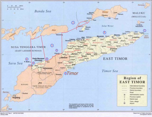
- The effect given to the small island (Kisar) that belongs to Indonesia located up-right of Timor Island. According to Hasan, it is possible for TL to ask Indonesia to give a half (or even less) effect to the island because it is very small compared to the whole TL. However, it is also possible for Indonesia to negotiate because the island should not be compared to the whole TL but to a similar island belongs to TL (Jaco) which is located near the island in question. If TL insists to consider the whole TL, Indonesia can argue to consider the whole Indonesia as well, which is undoubtedly, significantly larger than TL.
- The baselines pulled from Liran Islet (or island) which is located at the west of Wetar Island to Alor Island can be the part of archipelagic baseline which technically is straight baseline. However, it is not possible because it will cross the Internal Water of TL because one of TL’s islands, Atauro, which is located between Liran and Alor, will generate its own maritime zone. Concerns need to be given to this particular case.
- With regards to Oekusi, it will be difficult for Indonesia to draw baseline. According to Jalal, Indonesia is entitled to draw archipelagic baseline which is closed. This means Indonesia can pull the line from a point at Alor Island to one of common basepoints located at Timor Island, somewhere in the land borderline between Atapupu and Balibo and continue it along the coast until Wini. From the point the line can be drawn up to a point at Alor Island, continued to Pantar Island and down again a point at Citrana (see red line in the figure bellow). Jalal claimed that it is possible to draw such a line because, as mentioned previously, archipelagic baselines should be closed and the straight sections it produces do not exceed the limit, 125 n.m.
- The ownership of Batek Island. Orally, TL admitted that Batek belongs to Indonesia but when Indonesia asked TL to state it formally, TL refused it. The ownership of Batek Island will significantly influence the definition of maritime boundary because Batek, as an island, can generate its own maritime zone.
- The definition of Common Basepoints. Indonesia has defined its basepoints and those are regulated by PP 38/2002. However, the regulation does not include common basepoints. This research must simulate the location of common basepoints base of the rule and constraints in defining basepoints.
- TL basepoints. TL has not yet its basepoints along the northern coast. This means that to be able to draw the boundary line, it is necessary to define TL’s basepoints.
Adapted from: http://www.defence.gov.au/army/asnce/images/timor_map.jpg

No comments:
Post a Comment