
20 December 2004
Jo Ronalds
UNSW AusAID Liaison Officer
Dear Jo,
I am writing with regards to my plan to attend a software training conducted by my school, the School of Surveying and Spatial Information Systems, UNSW on February 21 – 25, 2005. The training is about the application of CARIS LOTS™ (see http://www.caris.com/products/product.cfm?productID=15) in maritime boundary delimitation. My school will invite a professional trainer from CARIS (http://www.caris.com), Canada to provide a tailored training, which will be open for public.
As you might know, my research is about the delimitation of maritime boundary between Indonesia and Timor Leste which will use the above mentioned software to generate the boundary lines. As the software is a new kind of software to me, it is clear that the training will be essential to accomplish my research. In addition, the training will be the first CARIS LOTS™ training conducted in Australia. For sure, it is going to be a good opportunity for me.
As part of the scholarship agreement, I kindly request AusAID to support me to attend the training by providing funds for the registration. Enclosed is an email from the trainer containing training details. A recommendation letter from my supervisor, Dr C. H. Schofield will be sent to you separately by email.
Thank you very much for your attention and cooperation. I am looking forward to hearing from you in the near future.
Yours sincerely,
I Made Andi Arsana
Student ID: 3082390
 Karya I Made Andi Arsana, ST., ME
Batas Maritim Antarnegara - Sebuah Tinjauan Teknis dan Yuridis
(Gadjah Mada University Press, 2007) more...
Karya I Made Andi Arsana, ST., ME
Batas Maritim Antarnegara - Sebuah Tinjauan Teknis dan Yuridis
(Gadjah Mada University Press, 2007) more...Monday, December 20, 2004
Letter to AusAID for Software Training
Response from Bakosurtanal
[calling pak sobar]
I haven’t mentioned that I got response from Bakosurtanal, have I? Bakosurtanal is an important institution I will visit during the fieldwork. I called Dr Sutisna (hereinafter referred to as Pak Soabar), head of the center for Boundary Mapping of Bakosurtanal. He answered my called warmly with his friendly “assalamualaikum”. Without doubt, I simply replied “walaikumsalam” followed by introduction. It did not take long for him to remember me when I said “Madé UGM”. He just did not realise that I called from Sydney because the strange number appeared on his mobile was [like] a Jakarta number.
Pak Sobar responded positively when I told him my plan to visit Bakosurtanal for obtaining data (topographic map). Only, he will not be around at the day (24-26 January 2005) for he will be in Mekah for “Ibadah Haji”. It doesn’t matter because, according to him, Bu Sari can help me to obtain the data. “Just lest us know your detail plan and data you need, Bu Sari will help you. You’ve known her haven’t you?”, he added.
I hope this journey can enrich my academic experience as well as strengthen the network I am currently developing.
Friday, December 10, 2004
One hour with Hasanudin Z. Abidin
[six-point suggestions]
Today, I have a chance to talk to Hasanudin Z. Abinin, the top-notch GPS guy from Indonesia. He was also one of the key persons who have conducted preliminary research on maritime Boundary delimitation between Indonesia and Timor Leste. I just “use” the chance to talk to him while he is visiting our school for the GNSS 2004 conference.
Hasan emphasized at least six (6) items I have to consider:
- The effect given to the small island (Kisar) that belongs to Indonesia located up-right of Timor Island. According to Hasan, it is possible for TL to ask Indonesia to give a half (or even less) effect to the island because it is very small compared to the whole TL. However, it is also possible for Indonesia to negotiate because the island should not be compared to the whole TL but to a similar island belongs to TL (Jaco) which is located near the island in question. If TL insists to consider the whole TL, Indonesia can argue to consider the whole Indonesia as well, which is undoubtedly, significantly larger than TL.
- The baselines pulled from Liran Islet (or island) which is located at the west of Wetar Island to Alor Island can be the part of archipelagic baseline which technically is straight baseline. However, it is not possible because it will cross the Internal Water of TL because one of TL’s islands, Atauro, which is located between Liran and Alor, will generate its own maritime zone. Concerns need to be given to this particular case.
- With regards to Oekusi, it will be difficult for Indonesia to draw baseline. According to Jalal, Indonesia is entitled to draw archipelagic baseline which is closed. This means Indonesia can pull the line from a point at Alor Island to one of common basepoints located at Timor Island, somewhere in the land borderline between Atapupu and Balibo and continue it along the coast until Wini. From the point the line can be drawn up to a point at Alor Island, continued to Pantar Island and down again a point at Citrana (see red line in the figure bellow). Jalal claimed that it is possible to draw such a line because, as mentioned previously, archipelagic baselines should be closed and the straight sections it produces do not exceed the limit, 125 n.m.
- The ownership of Batek Island. Orally, TL admitted that Batek belongs to Indonesia but when Indonesia asked TL to state it formally, TL refused it. The ownership of Batek Island will significantly influence the definition of maritime boundary because Batek, as an island, can generate its own maritime zone.
- The definition of Common Basepoints. Indonesia has defined its basepoints and those are regulated by PP 38/2002. However, the regulation does not include common basepoints. This research must simulate the location of common basepoints base of the rule and constraints in defining basepoints.
- TL basepoints. TL has not yet its basepoints along the northern coast. This means that to be able to draw the boundary line, it is necessary to define TL’s basepoints.
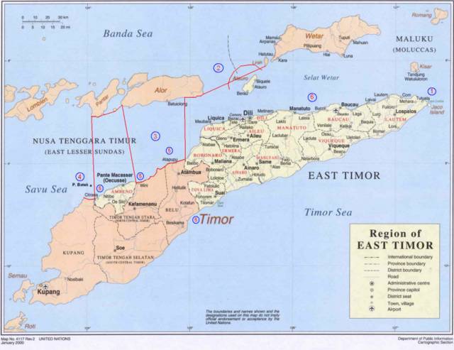
Adapted from: http://www.defence.gov.au/army/asnce/images/timor_map.jpg
More...
