
Do you think it is a corect illustration of normal baselines?
where:
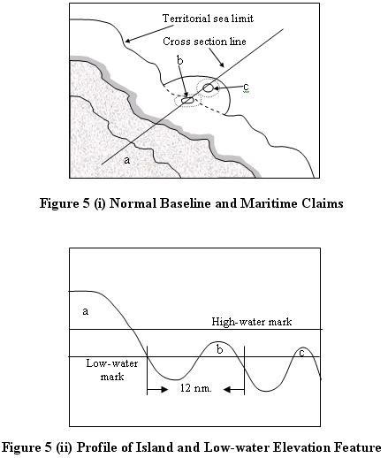
a : island
b : low-tide elevation that creates its own territorial sea
c : low-tide elevation that does not create its own territorial sea
Figure 5 (i) shows an island (a) with low-water line serving as a normal baseline. From the normal baseline, the limit of the territorial sea is measured seaward to the breadth of 12 nm. Since there is a low-water elevation feature (b) lies within the distance of 12 nm, it can be used as territorial sea basepoints (Carleton and Schofield, 2001: 23) and can generate its own territorial sea. On the other hand, another low-water elevation feature (c) does not generate its own territorial sea because its distance is more than 12 nm from the mainland. Figure 5(ii), showing the profile of the island and low-water features, better illustrates the distance from the mainland seaward. It also shows the definition of low-water elevation feature; the feature that is depicted above the water surface at the low-water.
 Karya I Made Andi Arsana, ST., ME
Batas Maritim Antarnegara - Sebuah Tinjauan Teknis dan Yuridis
(Gadjah Mada University Press, 2007) more...
Karya I Made Andi Arsana, ST., ME
Batas Maritim Antarnegara - Sebuah Tinjauan Teknis dan Yuridis
(Gadjah Mada University Press, 2007) more...Thursday, November 04, 2004
Is it the Correct Normal Baseline?
Subscribe to:
Post Comments (Atom)

No comments:
Post a Comment