

[ a journey plan]
Research Description
Research Title : Critical Study on the Technical Aspects of the Maritime Boundary Delimitations: A Case Study of the Maritime Boundary Delimitations between the Republic of Indonesia and the Republic Democratic of Timor Leste
Researcher : I Made Andi Arsana
Student Number : 3082390
Address : 2/10 Houston Rd, Kensington, 2033, NSW
Telephone : (02) 96626023.
Email : madeandi@student.unsw.edu.au
Degree : Master in Engineering
Supervisor : Professor Chris Rizos
Co-supervisor : Dr. Clive Schofield
Introduction
The current research project concerns the study of the technical aspects of maritime boundary delimitation using the Indonesia-Timor Leste Maritime Boundaries as the case study. This research aims to conduct a critical analysis of this case study in order to define possible maritime boundary delimitation options between Indonesia and Timor Leste and in so doing highlight potential challenges to delimitation and how to overcome these obstacles. Several alternatives of maritime boundary delimitations are expected to be the results as well as the advantage and disadvantages of each alternative solution.
To conduct this research, data and supporting information are essential, which will be collected by conducting a fieldwork to Indonesia. Data will be obtained from relevant departments and agencies through formal procedures. Some data and information may be obtained for free, while some will need to be purchased.
Fieldwork Objectives
The objectives of the fieldwork are:
- Collecting key data; nautical chats, and topographic maps.
- Searching for and collecting information and relevant documents related to the current status of maritime boundary delimitation between Indonesia and Timor Leste.
- Meeting the Indonesian experts and government officials in maritime boundary at Bakosurtanal, Bandung Institute of Technology, Gadjah Mada University, and the Indonesia’s Department of Foreign Affairs; and
- Updating/informing research progress to the Researcher’s home institution, Gadjah Mada University.
Fieldwork activities and their Relationship to the Research
- Obtaining recognized nautical charts of Timor Island and surrounding are from the Indonesian Hydrographic Office (Dishidros).
This chart will be the main source of data to draw the basepoints, baselines, maritime zones and maritime boundary lines. - Obtaining topographic map of Timor island and surrounding area from the National Coordinating Agency for Surveys and Mapping (Bakosurtanal);
This is to identify the location of Timor Island and other islands and islets located around Timor Island. Knowing the geographic location of the area in question is essential for the current research. - Searching for and collecting information and relevant documents related to the current status of maritime boundary delimitation between Indonesia and Timor Leste from the Indonesia’s Department of Foreign Affairs and the National Archives of the Republic of Indonesia.
Maritime boundary delimitation is a sensitive political process. It is important to know the history of the maritime boundary delimitation between Indonesia and Timor Leste, as well as the efforts that have been done to establish the maritime boundaries. This information is obtained from relevant official documents. - Meeting the Indonesian experts and government officials in maritime boundary at Bakosurtanal, Bandung Institute of Technology, Gadjah Mada University, and the Indonesia’s Department of Foreign Affairs;
This activity will help me as a researcher to know the latest issues and researches in the related field that have been undertaken previously by Indonesians experts, especially the current status of Indonesia-Timor Leste maritime boundaries. This information will be obtained from relevant official documents and interviews with key personnels - Meeting the researcher’s employer at Gadjah Mada University
This activity is to inform the employer about my research progress. This is important because after finishing the study, I am expected to go back to the same institution, continuing my obligation as a lecturer.
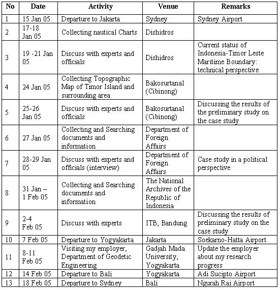
Fieldwork Schedule and Itinerary
Addresses:
- Dishidros: Jln. Pantai Kuta V/1 Ancol Timur Jakarta – Indonesia Phone: 62 21 64714810, Fax: 62 21 64714819, E-mail: infohid@indo.net.id
- Bakosurtanal: Jl Raya Jakarta-Bogor Km 46 Cibinong 15911 Phone: , Fax: , e-mail: pbw@bakosurtanal.go.id
- ITB (Department of Geodetic Engineering): Jl. Ganeça No. 10, Bandung, 40132 Phone: 62 22 2530701, Fax. 62 22 2530702 E-mail: dtgd@gd.itb.ac.id
- Department of Geodetic Engineering (UGM): Jl. Grafika No. 2, Yogyakarta, 55281, Indonesia Phone: 62 274 902121, Fax: 62 274 520226, E-mail: geodugm@idola.net.id

1 comment:
see u soon in Jakarta
Post a Comment